Le Mesnil-Eudes
| Le Mesnil-Eudes | |
|---|---|
| Commune | |
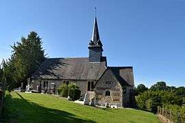 The church in Le Mesnil-Eudes | |
 Le Mesnil-Eudes Location within Normandy region  Le Mesnil-Eudes | |
| Coordinates: 49°05′37″N 0°10′51″E / 49.0936°N 0.1808°ECoordinates: 49°05′37″N 0°10′51″E / 49.0936°N 0.1808°E | |
| Country | France |
| Region | Normandy |
| Department | Calvados |
| Arrondissement | Lisieux |
| Canton | Mézidon-Canon |
| Intercommunality | CA Lisieux Normandie |
| Government | |
| • Mayor (2008–2014) | Michel Descrettes |
| Area1 | 8.42 km2 (3.25 sq mi) |
| Population (2008)2 | 315 |
| • Density | 37/km2 (97/sq mi) |
| Time zone | UTC+1 (CET) |
| • Summer (DST) | UTC+2 (CEST) |
| INSEE/Postal code | 14419 /14100 |
| Elevation |
60–176 m (197–577 ft) (avg. 100 m or 330 ft) |
|
1 French Land Register data, which excludes lakes, ponds, glaciers > 1 km2 (0.386 sq mi or 247 acres) and river estuaries. 2 Population without double counting: residents of multiple communes (e.g., students and military personnel) only counted once. | |
Le Mesnil-Eudes is a commune in the Calvados department in the Normandy region in northwestern France.
Population
| Historical population | ||
|---|---|---|
| Year | Pop. | ±% |
| 1962 | 236 | — |
| 1968 | 226 | −4.2% |
| 1975 | 228 | +0.9% |
| 1982 | 245 | +7.5% |
| 1990 | 288 | +17.6% |
| 1999 | 286 | −0.7% |
| 2008 | 315 | +10.1% |
See also
References
| Wikimedia Commons has media related to Le Mesnil-Eudes. |
This article is issued from
Wikipedia.
The text is licensed under Creative Commons - Attribution - Sharealike.
Additional terms may apply for the media files.