Bretteville-sur-Laize
| Bretteville-sur-Laize | ||
|---|---|---|
| Commune | ||
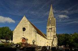 The church in Bretteville-sur-Laize | ||
| ||
 Bretteville-sur-Laize Location within Normandy region  Bretteville-sur-Laize | ||
| Coordinates: 49°02′45″N 0°19′26″W / 49.0458°N 0.3239°WCoordinates: 49°02′45″N 0°19′26″W / 49.0458°N 0.3239°W | ||
| Country | France | |
| Region | Normandy | |
| Department | Calvados | |
| Arrondissement | Caen | |
| Canton | Thury-Harcourt | |
| Intercommunality | Cingal | |
| Government | ||
| • Mayor (2008–2014) | Bruno François | |
| Area1 | 9.68 km2 (3.74 sq mi) | |
| Population (2008)2 | 1,566 | |
| • Density | 160/km2 (420/sq mi) | |
| Time zone | UTC+1 (CET) | |
| • Summer (DST) | UTC+2 (CEST) | |
| INSEE/Postal code | 14100 /14680 | |
| Elevation |
38–130 m (125–427 ft) (avg. 54 m or 177 ft) | |
|
1 French Land Register data, which excludes lakes, ponds, glaciers > 1 km2 (0.386 sq mi or 247 acres) and river estuaries. 2 Population without double counting: residents of multiple communes (e.g., students and military personnel) only counted once. | ||
.svg.png)
Bretteville-sur-Laize is a commune in the Calvados department in the Normandy region in northwestern France.
The scene of heavy fighting following the Normandy landings, much of the town is of post-World War II construction.
Population
| Historical population | ||
|---|---|---|
| Year | Pop. | ±% |
| 1962 | 1,246 | — |
| 1968 | 1,323 | +6.2% |
| 1975 | 1,299 | −1.8% |
| 1982 | 1,400 | +7.8% |
| 1990 | 1,341 | −4.2% |
| 1999 | 1,504 | +12.2% |
| 2008 | 1,566 | +4.1% |
International relations
Bretteville-sur-Laize is twinned with:
See also
References
| Wikimedia Commons has media related to Bretteville-sur-Laize. |
This article is issued from
Wikipedia.
The text is licensed under Creative Commons - Attribution - Sharealike.
Additional terms may apply for the media files.