La Houblonnière
| La Houblonnière | |
|---|---|
| Commune | |
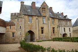 Chateau | |
 La Houblonnière Location within Normandy region  La Houblonnière | |
| Coordinates: 49°07′32″N 0°06′20″E / 49.1256°N 0.1056°ECoordinates: 49°07′32″N 0°06′20″E / 49.1256°N 0.1056°E | |
| Country | France |
| Region | Normandy |
| Department | Calvados |
| Arrondissement | Lisieux |
| Canton | Mézidon-Canon |
| Intercommunality | CA Lisieux Normandie |
| Government | |
| • Mayor (2008–2014) | Michel Dzierwa |
| Area1 | 7.1 km2 (2.7 sq mi) |
| Population (2008)2 | 317 |
| • Density | 45/km2 (120/sq mi) |
| Time zone | UTC+1 (CET) |
| • Summer (DST) | UTC+2 (CEST) |
| INSEE/Postal code | 14337 /14340 |
| Elevation |
35–163 m (115–535 ft) (avg. 80 m or 260 ft) |
|
1 French Land Register data, which excludes lakes, ponds, glaciers > 1 km2 (0.386 sq mi or 247 acres) and river estuaries. 2 Population without double counting: residents of multiple communes (e.g., students and military personnel) only counted once. | |
La Houblonnière is a commune in the Calvados department in the Normandy region in northwestern France.
Population
| Historical population | ||
|---|---|---|
| Year | Pop. | ±% |
| 1962 | 184 | — |
| 1968 | 141 | −23.4% |
| 1975 | 144 | +2.1% |
| 1982 | 155 | +7.6% |
| 1990 | 211 | +36.1% |
| 1999 | 234 | +10.9% |
| 2008 | 317 | +35.5% |
See also
References
| Wikimedia Commons has media related to La Houblonnière. |
This article is issued from
Wikipedia.
The text is licensed under Creative Commons - Attribution - Sharealike.
Additional terms may apply for the media files.