Fontaine-Étoupefour
| Fontaine-Étoupefour | |
|---|---|
| Commune | |
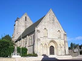 St. Pierre Church | |
 Fontaine-Étoupefour Location within Normandy region  Fontaine-Étoupefour | |
| Coordinates: 49°08′49″N 0°27′10″W / 49.1469°N 0.4528°WCoordinates: 49°08′49″N 0°27′10″W / 49.1469°N 0.4528°W | |
| Country | France |
| Region | Normandy |
| Department | Calvados |
| Arrondissement | Caen |
| Canton | Évrecy |
| Intercommunality | CU Caen la Mer |
| Government | |
| • Mayor (2008–2014) | Bernard Énault |
| Area1 | 5.08 km2 (1.96 sq mi) |
| Population (2008)2 | 1,898 |
| • Density | 370/km2 (970/sq mi) |
| Time zone | UTC+1 (CET) |
| • Summer (DST) | UTC+2 (CEST) |
| INSEE/Postal code | 14274 /14790 |
| Elevation |
19–111 m (62–364 ft) (avg. 32 m or 105 ft) |
|
1 French Land Register data, which excludes lakes, ponds, glaciers > 1 km2 (0.386 sq mi or 247 acres) and river estuaries. 2 Population without double counting: residents of multiple communes (e.g., students and military personnel) only counted once. | |
Fontaine-Étoupefour is a commune in the Calvados department in the Normandy region in northwestern France.
Population
| Historical population | ||
|---|---|---|
| Year | Pop. | ±% |
| 1793 | 491 | — |
| 1800 | 490 | −0.2% |
| 1806 | 642 | +31.0% |
| 1821 | 591 | −7.9% |
| 1831 | 662 | +12.0% |
| 1836 | 668 | +0.9% |
| 1841 | 666 | −0.3% |
| 1846 | 640 | −3.9% |
| 1851 | 662 | +3.4% |
| 1856 | 631 | −4.7% |
| 1861 | 628 | −0.5% |
| 1866 | 604 | −3.8% |
| 1872 | 526 | −12.9% |
| 1876 | 530 | +0.8% |
| 1881 | 517 | −2.5% |
| 1886 | 468 | −9.5% |
| 1891 | 461 | −1.5% |
| 1896 | 426 | −7.6% |
| 1901 | 404 | −5.2% |
| 1906 | 406 | +0.5% |
| 1911 | 337 | −17.0% |
| 1921 | 290 | −13.9% |
| 1926 | 283 | −2.4% |
| 1931 | 284 | +0.4% |
| 1936 | 286 | +0.7% |
| 1946 | 301 | +5.2% |
| 1954 | 359 | +19.3% |
| 1962 | 465 | +29.5% |
| 1968 | 590 | +26.9% |
| 1975 | 960 | +62.7% |
| 1982 | 1,152 | +20.0% |
| 1990 | 1,627 | +41.2% |
| 1999 | 1,676 | +3.0% |
| 2008 | 1,898 | +13.2% |
See also
References
External links
| Wikimedia Commons has media related to Fontaine-Étoupefour. |
This article is issued from
Wikipedia.
The text is licensed under Creative Commons - Attribution - Sharealike.
Additional terms may apply for the media files.