Vieux, Calvados
| Vieux | |
|---|---|
| Commune | |
 Roman ruins | |
 Vieux Location within Normandy region  Vieux | |
| Coordinates: 49°06′30″N 0°25′57″W / 49.1083°N 0.4325°WCoordinates: 49°06′30″N 0°25′57″W / 49.1083°N 0.4325°W | |
| Country | France |
| Region | Normandy |
| Department | Calvados |
| Arrondissement | Caen |
| Canton | Évrecy |
| Intercommunality | Évrecy-Orne-Odon |
| Government | |
| • Mayor (2008–2014) | Mireille Beuve |
| Area1 | 5.50 km2 (2.12 sq mi) |
| Population (2008)2 | 595 |
| • Density | 110/km2 (280/sq mi) |
| Time zone | UTC+1 (CET) |
| • Summer (DST) | UTC+2 (CEST) |
| INSEE/Postal code | 14747 /14930 |
| Elevation |
25–112 m (82–367 ft) (avg. 93 m or 305 ft) |
|
1 French Land Register data, which excludes lakes, ponds, glaciers > 1 km2 (0.386 sq mi or 247 acres) and river estuaries. 2 Population without double counting: residents of multiple communes (e.g., students and military personnel) only counted once. | |
Vieux is a commune in the Calvados department in the Normandy region in northwestern France.
History
The town contains numerous Roman era ruins, as Vieux was a Settlement called Araegenve, and appears on the Roman map, Tabula Peutingeriana.
During the Battle of Normandy in 1944, Vieux was designated as Hill 112 position, a strategic point for the Battle of Caen, the area of rue d'Esquay and the Bas de Vieux were badly affected by the allied bombardment of July 6, 1944. The portion of these streets, destroyed at this time are now dated for its name.
Sights
- The archaeological museum of Vieux-la-Romaine (as Aregenua, Vieux was capital of the Viducasses tribe).
- Roman villa of Bas de Vieux
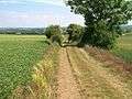 Le chemin Haussé.
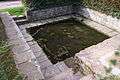 Lavoir de la place Saint-Martin.
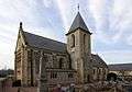 L'église Saint-Laurent.
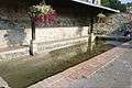 Lavoir prés de church of Saint-Laurent.
 Le lavoir romain des Mareaux.
Population
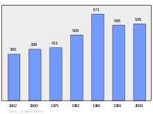
Population of Vieux Municipality
| Historical population | ||
|---|---|---|
| Year | Pop. | ±% |
| 1793 | 520 | — |
| 1800 | 543 | +4.4% |
| 1841 | 580 | +6.8% |
| 1876 | 456 | −21.4% |
| 1881 | 456 | +0.0% |
| 1896 | 381 | −16.4% |
| 1906 | 400 | +5.0% |
| 1962 | 360 | −10.0% |
| 1968 | 398 | +10.6% |
| 1975 | 411 | +3.3% |
| 1982 | 509 | +23.8% |
| 1990 | 671 | +31.8% |
| 1999 | 585 | −12.8% |
| 2008 | 595 | +1.7% |
See also
References
External links
| Wikimedia Commons has media related to Vieux-la-Romaine. |
| Authority control |
|---|
This article is issued from
Wikipedia.
The text is licensed under Creative Commons - Attribution - Sharealike.
Additional terms may apply for the media files.