Tournebu
| Tournebu | |
|---|---|
| Commune | |
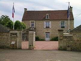 The town hall in Tournebu | |
 Tournebu Location within Normandy region  Tournebu | |
| Coordinates: 48°58′11″N 0°20′22″W / 48.9697°N 0.3394°WCoordinates: 48°58′11″N 0°20′22″W / 48.9697°N 0.3394°W | |
| Country | France |
| Region | Normandy |
| Department | Calvados |
| Arrondissement | Caen |
| Canton | Thury-Harcourt |
| Government | |
| • Mayor (2008–2014) | Jean Vanryckeghem |
| Area1 | 11.4 km2 (4.4 sq mi) |
| Population (2008)2 | 359 |
| • Density | 31/km2 (82/sq mi) |
| Time zone | UTC+1 (CET) |
| • Summer (DST) | UTC+2 (CEST) |
| INSEE/Postal code | 14703 /14220 |
| Elevation |
109–188 m (358–617 ft) (avg. 150 m or 490 ft) |
|
1 French Land Register data, which excludes lakes, ponds, glaciers > 1 km2 (0.386 sq mi or 247 acres) and river estuaries. 2 Population without double counting: residents of multiple communes (e.g., students and military personnel) only counted once. | |
Tournebu is a commune in the Calvados department in the Normandy region in northwestern France.
Population
| Historical population | ||
|---|---|---|
| Year | Pop. | ±% |
| 1962 | 289 | — |
| 1968 | 297 | +2.8% |
| 1975 | 286 | −3.7% |
| 1982 | 276 | −3.5% |
| 1990 | 309 | +12.0% |
| 1999 | 295 | −4.5% |
| 2008 | 359 | +21.7% |
Sights
- Donjon (the keep)
See also
References
| Wikimedia Commons has media related to Tournebu. |
This article is issued from
Wikipedia.
The text is licensed under Creative Commons - Attribution - Sharealike.
Additional terms may apply for the media files.