Barbeville
| Barbeville | |
|---|---|
| Commune | |
 Barbeville Chateau | |
 Barbeville Location within Normandy region  Barbeville | |
| Coordinates: 49°16′32″N 0°44′52″W / 49.2756°N 0.7478°WCoordinates: 49°16′32″N 0°44′52″W / 49.2756°N 0.7478°W | |
| Country | France |
| Region | Normandy |
| Department | Calvados |
| Arrondissement | Bayeux |
| Canton | Bayeux |
| Intercommunality | Bayeux Intercom |
| Government | |
| • Mayor (2008–2020) | Denis Énée |
| Area1 | 3.47 km2 (1.34 sq mi) |
| Population (2010)2 | 180 |
| • Density | 52/km2 (130/sq mi) |
| Time zone | UTC+1 (CET) |
| • Summer (DST) | UTC+2 (CEST) |
| INSEE/Postal code | 14040 /14400 |
| Elevation |
22–62 m (72–203 ft) (avg. 53 m or 174 ft) |
|
1 French Land Register data, which excludes lakes, ponds, glaciers > 1 km2 (0.386 sq mi or 247 acres) and river estuaries. 2 Population without double counting: residents of multiple communes (e.g., students and military personnel) only counted once. | |
Barbeville ![]()
The inhabitants of the commune are known as Barbevillais or Barbevillaises.[2]
Geography
Barbeville is located in the Drône valley some 4 km west of Bayeux. Access to the commune is by the D96 road from Bayeux which passes through the heart of the commune and the village and continues west to Rubercy. The D5 from Bayeux to Le Molay-Littry forms the southern border of the commune. The D169 from Vaucelles in the north passes south down the eastern side of the commune and continues to Ranchy. The Route nationale N13 passes through the eastern arm of the commune with the nearest exit being Exit ![]()
The Drôme river forms the entire eastern border of the commune as it flows north to join the Aure south-west of Commes. The Ruisseau de Cottun flows from the west of the commune to join the Drome on the eastern border. The Ruisseau de Saint-Symphorien flows along the northern border towards the east, forming parts of the border and joining the Drome at the north-eastern tip of the commune.
Neighbouring communes and villages | ||||||||||
|---|---|---|---|---|---|---|---|---|---|---|
| ||||||||||
History
Barbeville appears as Barbeville on the 1750 Cassini Map[3] but unusually does not appear on the 1790 version.[4]
Administration
| From | To | Name | Party | Position |
|---|---|---|---|---|
| 1968 | 1989 | Philippe Henry | Horse Breeder | |
| 1989 | 2001 | Hervé Legrand | ||
| 2001 | 2008 | Henri Kliszowski | Retired Surgeon | |
| 2008 | 2020 | Denis Énée | Retired Banker |
(Not all data is known)
Demography
In 2010 the commune had 180 inhabitants. The evolution of the number of inhabitants is known from the population censuses conducted in the commune since 1793. From the 21st century, a census of communes with fewer than 10,000 inhabitants is held every five years, unlike larger communes that have a sample survey every year.[Note 1]
| 1793 | 1800 | 1806 | 1821 | 1831 | 1836 | 1841 | 1846 | 1851 |
|---|---|---|---|---|---|---|---|---|
| 254 | 196 | 195 | 223 | 217 | 222 | 216 | 190 | 193 |
| 1856 | 1861 | 1866 | 1872 | 1876 | 1881 | 1886 | 1891 | 1896 |
|---|---|---|---|---|---|---|---|---|
| 194 | 202 | 187 | 172 | 194 | 171 | 174 | 211 | 217 |
| 1901 | 1906 | 1911 | 1921 | 1926 | 1931 | 1936 | 1946 | 1954 |
|---|---|---|---|---|---|---|---|---|
| 224 | 207 | 224 | 203 | 202 | 204 | 188 | 197 | 186 |
| 1962 | 1968 | 1975 | 1982 | 1990 | 1999 | 2006 | 2010 | - |
|---|---|---|---|---|---|---|---|---|
| 169 | 196 | 181 | 174 | 151 | 163 | 178 | 180 | - |
Sources : Ldh/EHESS/Cassini until 1962, INSEE database from 1968 (population without double counting and municipal population from 2006)

Sites and monuments
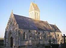
The commune has two structures which are registered as historical monuments:
- A Chateau (18th century)

- The Church of Saint-Martin (13th century)

- Other sites of interest
- The Barbeville Stud was created at the end of the 19th century by Count Foy. It is a centre for the breeding of yearlings. The Barbeville prize was contested in a race for the first time at Longchamp in 1889 and it still exists.
- The Chateau of Monts (19th century)
- The Cambray Manor was built by Népomucène Lemercier at the end of the 18th century.
Notable people linked to the commune

- Henri Gérard (1818-1903), MP for Calvados from 1881 to 1902, was mayor of Barbeville.
See also
Notes
- ↑ At the beginning of the 21st century, the methods of identification have been modified by Law No. 2002-276 of 27 February 2002 Archived 6 March 2016 at the Wayback Machine., the so-called "law of local democracy" and in particular Title V "census operations" allows, after a transitional period running from 2004 to 2008, the annual publication of the legal population of the different French administrative districts. For communes with a population greater than 10,000 inhabitants, a sample survey is conducted annually, the entire territory of these communes is taken into account at the end of the period of five years. The first "legal population" after 1999 under this new law came into force on 1 January 2009 and was based on the census of 2006.
References
- ↑ Barbeville on Lion1906
- ↑ Inhabitants of Calvados (in French)
- ↑ Barbeville on the 1750 Cassini Map
- ↑ Barbeville on the 1790 Cassini Map
- ↑ List of Mayors of France (in French)
- ↑ Ministry of Culture, Mérimée PA00111033 Chateau (in French)
- ↑ Ministry of Culture, Mérimée PA00111034 Church of Saint-Martin (in French)

- ↑ Ministry of Culture, Palissy PM14001303 Instrumental part PM14001303 Organ (in French)
| Wikimedia Commons has media related to Barbeville. |