Saint-Pierre-du-Bû
| Saint-Pierre-du-Bû | |
|---|---|
| Commune | |
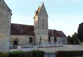 The church in Saint-Pierre-du-Bû | |
 Saint-Pierre-du-Bû Location within Normandy region  Saint-Pierre-du-Bû | |
| Coordinates: 48°52′08″N 0°12′57″W / 48.8689°N 0.2158°WCoordinates: 48°52′08″N 0°12′57″W / 48.8689°N 0.2158°W | |
| Country | France |
| Region | Normandy |
| Department | Calvados |
| Arrondissement | Caen |
| Canton | Falaise |
| Intercommunality | Pays de Falaise |
| Government | |
| • Mayor (2008–2014) | Daniel Liégard |
| Area1 | 7.39 km2 (2.85 sq mi) |
| Population (2008)2 | 450 |
| • Density | 61/km2 (160/sq mi) |
| Time zone | UTC+1 (CET) |
| • Summer (DST) | UTC+2 (CEST) |
| INSEE/Postal code | 14649 /14700 |
| Elevation |
159–236 m (522–774 ft) (avg. 204 m or 669 ft) |
|
1 French Land Register data, which excludes lakes, ponds, glaciers > 1 km2 (0.386 sq mi or 247 acres) and river estuaries. 2 Population without double counting: residents of multiple communes (e.g., students and military personnel) only counted once. | |
Saint-Pierre-du-Bû is a commune in the Calvados department in the Normandy region in northwestern France.
Population
| Historical population | ||
|---|---|---|
| Year | Pop. | ±% |
| 1962 | 251 | — |
| 1968 | 238 | −5.2% |
| 1975 | 207 | −13.0% |
| 1982 | 242 | +16.9% |
| 1990 | 335 | +38.4% |
| 1999 | 412 | +23.0% |
| 2008 | 450 | +9.2% |
See also
References
| Wikimedia Commons has media related to Saint-Pierre-du-Bû. |
This article is issued from
Wikipedia.
The text is licensed under Creative Commons - Attribution - Sharealike.
Additional terms may apply for the media files.