Rocquancourt
| Rocquancourt | |
|---|---|
| Commune | |
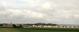 A general view of Rocquancourt | |
 Rocquancourt Location within Normandy region  Rocquancourt | |
| Coordinates: 49°05′43″N 0°19′16″W / 49.0953°N 0.3211°WCoordinates: 49°05′43″N 0°19′16″W / 49.0953°N 0.3211°W | |
| Country | France |
| Region | Normandy |
| Department | Calvados |
| Arrondissement | Caen |
| Canton | Évrecy |
| Intercommunality | CU Caen la Mer |
| Government | |
| • Mayor (2008–2014) | Sylviane Vastel |
| Area1 | 2.75 km2 (1.06 sq mi) |
| Population (2008)2 | 745 |
| • Density | 270/km2 (700/sq mi) |
| Time zone | UTC+1 (CET) |
| • Summer (DST) | UTC+2 (CEST) |
| INSEE/Postal code | 14538 /14540 |
| Elevation | 68–92 m (223–302 ft) |
|
1 French Land Register data, which excludes lakes, ponds, glaciers > 1 km2 (0.386 sq mi or 247 acres) and river estuaries. 2 Population without double counting: residents of multiple communes (e.g., students and military personnel) only counted once. | |
Rocquancourt is a commune in the Calvados department in the Normandy region in northwestern France.
Population
| Historical population | ||
|---|---|---|
| Year | Pop. | ±% |
| 1962 | 440 | — |
| 1968 | 506 | +15.0% |
| 1975 | 503 | −0.6% |
| 1982 | 530 | +5.4% |
| 1990 | 519 | −2.1% |
| 1999 | 581 | +11.9% |
| 2008 | 745 | +28.2% |
Gallery
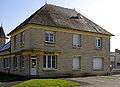 Town hall
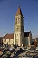 St. Martin
 War memorial
See also
References
| Wikimedia Commons has media related to Rocquancourt. |
This article is issued from
Wikipedia.
The text is licensed under Creative Commons - Attribution - Sharealike.
Additional terms may apply for the media files.