Colombelles
| Colombelles | ||
|---|---|---|
| Commune | ||
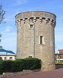 Norman tower | ||
| ||
 Colombelles Location within Normandy region  Colombelles | ||
| Coordinates: 49°12′18″N 0°17′46″W / 49.205°N 0.2961°WCoordinates: 49°12′18″N 0°17′46″W / 49.205°N 0.2961°W | ||
| Country | France | |
| Region | Normandy | |
| Department | Calvados | |
| Arrondissement | Caen | |
| Canton | Hérouville-Saint-Clair | |
| Intercommunality | CU Caen la Mer | |
| Government | ||
| • Mayor (2008–2014) | Colin Sueur | |
| Area1 | 7.14 km2 (2.76 sq mi) | |
| Population (2008)2 | 5,895 | |
| • Density | 830/km2 (2,100/sq mi) | |
| Time zone | UTC+1 (CET) | |
| • Summer (DST) | UTC+2 (CEST) | |
| INSEE/Postal code | 14167 /14460 | |
| Elevation |
2–49 m (6.6–160.8 ft) (avg. 40 m or 130 ft) | |
|
1 French Land Register data, which excludes lakes, ponds, glaciers > 1 km2 (0.386 sq mi or 247 acres) and river estuaries. 2 Population without double counting: residents of multiple communes (e.g., students and military personnel) only counted once. | ||

Colombelles is a commune in the Calvados department in the Normandy region in northwestern France.
It is located on the Canal de Caen à la Mer.
Population
The population of this sleepy little village mushroomed after August Thyssen bought some land in 1909 and established a steel mill there.
| Historical population | ||
|---|---|---|
| Year | Pop. | ±% |
| 1911 | 186 | — |
| 1914 | 178 | −4.3% |
| 1921 | 2,301 | +1192.7% |
| 1927 | 2,556 | +11.1% |
| 1932 | 3,108 | +21.6% |
| 1939 | 3,452 | +11.1% |
| 1999 | 6,235 | +80.6% |
| 2008 | 5,895 | −5.5% |
International relations
Colombelles is twinned with Fremington, Devon (UK) since 1983 and with Steinheim am Albuch (Baden-Württemberg, Germany) since 1986 (see that article in German).
See also
References
| Wikimedia Commons has media related to Colombelles. |
This article is issued from
Wikipedia.
The text is licensed under Creative Commons - Attribution - Sharealike.
Additional terms may apply for the media files.