Crocy
| Crocy | |
|---|---|
| Commune | |
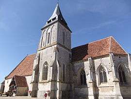 The church in Crocy | |
 Crocy Location within Normandy region  Crocy | |
| Coordinates: 48°52′51″N 0°03′51″W / 48.8808°N 0.0642°WCoordinates: 48°52′51″N 0°03′51″W / 48.8808°N 0.0642°W | |
| Country | France |
| Region | Normandy |
| Department | Calvados |
| Arrondissement | Caen |
| Canton | Falaise |
| Intercommunality | Pays de Falaise |
| Government | |
| • Mayor (2014–2020) | Clara Dewaële |
| Area1 | 10.07 km2 (3.89 sq mi) |
| Population (2014)2 | 310 |
| • Density | 31/km2 (80/sq mi) |
| Time zone | UTC+1 (CET) |
| • Summer (DST) | UTC+2 (CEST) |
| INSEE/Postal code | 14206 /14620 |
| Elevation |
56–106 m (184–348 ft) (avg. 110 m or 360 ft) |
|
1 French Land Register data, which excludes lakes, ponds, glaciers > 1 km2 (0.386 sq mi or 247 acres) and river estuaries. 2 Population without double counting: residents of multiple communes (e.g., students and military personnel) only counted once. | |
Crocy is a commune in the Calvados department and Normandy region of north-western France. It is situated close to Falaise.
The name is believed to derive from the Gallo-Roman personal name Crossius.
Population
| Historical population | ||
|---|---|---|
| Year | Pop. | ±% |
| 1946 | 386 | — |
| 1954 | 359 | −7.0% |
| 1962 | 348 | −3.1% |
| 1968 | 311 | −10.6% |
| 1975 | 311 | +0.0% |
| 1982 | 305 | −1.9% |
| 1990 | 304 | −0.3% |
| 1999 | 289 | −4.9% |
| 2005 | 292 | +1.0% |
| 2014 | 310 | +6.2% |
See also
References
| Wikimedia Commons has media related to Crocy. |
This article is issued from
Wikipedia.
The text is licensed under Creative Commons - Attribution - Sharealike.
Additional terms may apply for the media files.