Saint-Louet-sur-Seulles
| Saint-Louet-sur-Seulles | |
|---|---|
| Commune | |
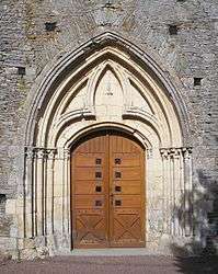 The doorway of the church | |
 Saint-Louet-sur-Seulles Location within Normandy region  Saint-Louet-sur-Seulles | |
| Coordinates: 49°05′51″N 0°39′57″W / 49.0975°N 0.6658°WCoordinates: 49°05′51″N 0°39′57″W / 49.0975°N 0.6658°W | |
| Country | France |
| Region | Normandy |
| Department | Calvados |
| Arrondissement | Vire |
| Canton | Aunay-sur-Odon |
| Intercommunality | Villers-Bocage |
| Government | |
| • Mayor (2008–2014) | René Desmares |
| Area1 | 4.33 km2 (1.67 sq mi) |
| Population (2008)2 | 182 |
| • Density | 42/km2 (110/sq mi) |
| Time zone | UTC+1 (CET) |
| • Summer (DST) | UTC+2 (CEST) |
| INSEE/Postal code | 14607 /14310 |
| Elevation |
77–141 m (253–463 ft) (avg. 93 m or 305 ft) |
|
1 French Land Register data, which excludes lakes, ponds, glaciers > 1 km2 (0.386 sq mi or 247 acres) and river estuaries. 2 Population without double counting: residents of multiple communes (e.g., students and military personnel) only counted once. | |
Saint-Louet-sur-Seulles is a commune in the Calvados department in the Normandy region in northwestern France.
Population
| Historical population | ||
|---|---|---|
| Year | Pop. | ±% |
| 1962 | 156 | — |
| 1968 | 158 | +1.3% |
| 1975 | 165 | +4.4% |
| 1982 | 128 | −22.4% |
| 1990 | 144 | +12.5% |
| 1999 | 171 | +18.8% |
| 2008 | 182 | +6.4% |
See also
References
| Wikimedia Commons has media related to Saint-Louet-sur-Seulles. |
This article is issued from
Wikipedia.
The text is licensed under Creative Commons - Attribution - Sharealike.
Additional terms may apply for the media files.