Longvillers
| Longvillers | |
|---|---|
| Commune | |
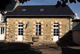 Town hall | |
 Longvillers Location within Normandy region  Longvillers | |
| Coordinates: 49°03′09″N 0°37′48″W / 49.0525°N 0.63°WCoordinates: 49°03′09″N 0°37′48″W / 49.0525°N 0.63°W | |
| Country | France |
| Region | Normandy |
| Department | Calvados |
| Arrondissement | Vire |
| Canton | Aunay-sur-Odon |
| Intercommunality | Villers-Bocage Intercom |
| Government | |
| • Mayor (2008–2014) | Jacques Langlois |
| Area1 | 6.65 km2 (2.57 sq mi) |
| Population (2008)2 | 334 |
| • Density | 50/km2 (130/sq mi) |
| Time zone | UTC+1 (CET) |
| • Summer (DST) | UTC+2 (CEST) |
| INSEE/Postal code | 14379 /14310 |
| Elevation |
87–187 m (285–614 ft) (avg. 118 m or 387 ft) |
|
1 French Land Register data, which excludes lakes, ponds, glaciers > 1 km2 (0.386 sq mi or 247 acres) and river estuaries. 2 Population without double counting: residents of multiple communes (e.g., students and military personnel) only counted once. | |
Longvillers is a commune in the Calvados department in the Normandy region in northwestern France.
There are no shops, nor any commercial outlets in the hamlet, the nearest shops, food, bars or hotels are located either in Villers-Bocage or Aunay-sur-Odon.
Population
| Historical population | ||
|---|---|---|
| Year | Pop. | ±% |
| 1962 | 255 | — |
| 1968 | 221 | −13.3% |
| 1975 | 218 | −1.4% |
| 1982 | 268 | +22.9% |
| 1990 | 288 | +7.5% |
| 1999 | 323 | +12.2% |
| 2008 | 334 | +3.4% |
| 2011 | 357 | +6.9% |
| 2012 | 369 | +3.4% |
See also
References
| Wikimedia Commons has media related to Longvillers. |
This article is issued from
Wikipedia.
The text is licensed under Creative Commons - Attribution - Sharealike.
Additional terms may apply for the media files.