Villerville
| Villerville | ||
|---|---|---|
| Commune | ||
 The church in Villerville | ||
| ||
 Villerville Location within Normandy region  Villerville | ||
| Coordinates: 49°24′06″N 0°07′46″E / 49.4017°N 0.1294°ECoordinates: 49°24′06″N 0°07′46″E / 49.4017°N 0.1294°E | ||
| Country | France | |
| Region | Normandy | |
| Department | Calvados | |
| Arrondissement | Lisieux | |
| Canton | Honfleur-Deauville | |
| Intercommunality | Cœur Côte Fleurie | |
| Government | ||
| • Mayor (2008–2014) | Michel Marescot | |
| Area1 | 3.30 km2 (1.27 sq mi) | |
| Population (2008)2 | 771 | |
| • Density | 230/km2 (610/sq mi) | |
| Time zone | UTC+1 (CET) | |
| • Summer (DST) | UTC+2 (CEST) | |
| INSEE/Postal code | 14755 /14113 | |
| Elevation |
0–144 m (0–472 ft) (avg. 60 m or 200 ft) | |
|
1 French Land Register data, which excludes lakes, ponds, glaciers > 1 km2 (0.386 sq mi or 247 acres) and river estuaries. 2 Population without double counting: residents of multiple communes (e.g., students and military personnel) only counted once. | ||
Villerville is a commune in the Calvados department in the Normandy region in northwestern France. the commune is located towards the eastern end of the 40 km (25 mi) coastline called the Côte Fleurie (Flowery Coast).
Population
| Historical population | ||
|---|---|---|
| Year | Pop. | ±% |
| 1946 | 728 | — |
| 1954 | 801 | +10.0% |
| 1962 | 750 | −6.4% |
| 1968 | 728 | −2.9% |
| 1975 | 722 | −0.8% |
| 1982 | 733 | +1.5% |
| 1990 | 686 | −6.4% |
| 1999 | 676 | −1.5% |
| 2008 | 771 | +14.1% |
International relations
Villerville is twinned with:
- Hausen bei Würzburg (in Bavaria, Germany)
See also
References
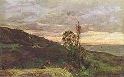
Near Villerville, Charles-François Daubigny, 1873.
External links
| Wikimedia Commons has media related to Villerville. |
- Official site
- Extraordinary history of the theatre inside a whale, at Villerville
This article is issued from
Wikipedia.
The text is licensed under Creative Commons - Attribution - Sharealike.
Additional terms may apply for the media files.