Colombiers-sur-Seulles
| Colombiers-sur-Seulles | ||
|---|---|---|
| Commune | ||
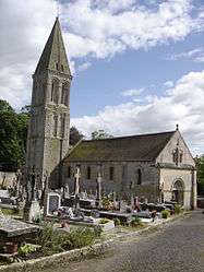 The church in Colombiers-sur-Seulles | ||
| ||
 Colombiers-sur-Seulles Location within Normandy region  Colombiers-sur-Seulles | ||
| Coordinates: 49°17′38″N 0°30′37″W / 49.2939°N 0.5103°WCoordinates: 49°17′38″N 0°30′37″W / 49.2939°N 0.5103°W | ||
| Country | France | |
| Region | Normandy | |
| Department | Calvados | |
| Arrondissement | Bayeux | |
| Canton | Bretteville-l'Orgueilleuse | |
| Intercommunality | Orival | |
| Government | ||
| • Mayor (2008–2014) | Hervé Richard | |
| Area1 | 3.29 km2 (1.27 sq mi) | |
| Population (2008)2 | 164 | |
| • Density | 50/km2 (130/sq mi) | |
| Time zone | UTC+1 (CET) | |
| • Summer (DST) | UTC+2 (CEST) | |
| INSEE/Postal code | 14169 /14480 | |
| Elevation |
2–56 m (6.6–183.7 ft) (avg. 40 m or 130 ft) | |
|
1 French Land Register data, which excludes lakes, ponds, glaciers > 1 km2 (0.386 sq mi or 247 acres) and river estuaries. 2 Population without double counting: residents of multiple communes (e.g., students and military personnel) only counted once. | ||
.svg.png)
Colombiers-sur-Seulles is a commune in the Calvados department in the Normandy region in northwestern France.
Population
| Historical population | ||
|---|---|---|
| Year | Pop. | ±% |
| 1962 | 181 | — |
| 1968 | 164 | −9.4% |
| 1975 | 166 | +1.2% |
| 1982 | 158 | −4.8% |
| 1990 | 160 | +1.3% |
| 1999 | 181 | +13.1% |
| 2008 | 164 | −9.4% |
See also
References
| Wikimedia Commons has media related to Colombiers-sur-Seulles. |
This article is issued from
Wikipedia.
The text is licensed under Creative Commons - Attribution - Sharealike.
Additional terms may apply for the media files.