Cordebugle
| Cordebugle | |
|---|---|
| Commune | |
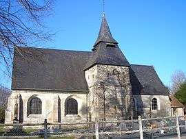 The church in Cordebugle | |
 Cordebugle Location within Normandy region  Cordebugle | |
| Coordinates: 49°06′42″N 0°22′50″E / 49.1117°N 0.3806°ECoordinates: 49°06′42″N 0°22′50″E / 49.1117°N 0.3806°E | |
| Country | France |
| Region | Normandy |
| Department | Calvados |
| Arrondissement | Lisieux |
| Canton | Lisieux |
| Intercommunality | CA Lisieux Normandie |
| Government | |
| • Mayor (2008–2014) | Alain Dutot |
| Area1 | 8.97 km2 (3.46 sq mi) |
| Population (2008)2 | 125 |
| • Density | 14/km2 (36/sq mi) |
| Time zone | UTC+1 (CET) |
| • Summer (DST) | UTC+2 (CEST) |
| INSEE/Postal code | 14179 /14100 |
| Elevation |
86–194 m (282–636 ft) (avg. 156 m or 512 ft) |
|
1 French Land Register data, which excludes lakes, ponds, glaciers > 1 km2 (0.386 sq mi or 247 acres) and river estuaries. 2 Population without double counting: residents of multiple communes (e.g., students and military personnel) only counted once. | |
Cordebugle (pro. kor-deh-beu-glh) is a commune in the Calvados department in the Normandy region in northwestern France.
Population
| Historical population | ||
|---|---|---|
| Year | Pop. | ±% |
| 1962 | 73 | — |
| 1968 | 72 | −1.4% |
| 1975 | 72 | +0.0% |
| 1982 | 101 | +40.3% |
| 1990 | 110 | +8.9% |
| 1999 | 91 | −17.3% |
| 2008 | 125 | +37.4% |
See also
References
| Wikimedia Commons has media related to Cordebugle. |
This article is issued from
Wikipedia.
The text is licensed under Creative Commons - Attribution - Sharealike.
Additional terms may apply for the media files.