Pierrefitte-en-Cinglais
| Pierrefitte-en-Cinglais | |
|---|---|
| Commune | |
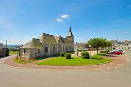 The church in Pierrefitte-en-Cinglais | |
 Pierrefitte-en-Cinglais Location within Normandy region  Pierrefitte-en-Cinglais | |
| Coordinates: 48°54′14″N 0°23′12″W / 48.9039°N 0.3867°WCoordinates: 48°54′14″N 0°23′12″W / 48.9039°N 0.3867°W | |
| Country | France |
| Region | Normandy |
| Department | Calvados |
| Arrondissement | Caen |
| Canton | Falaise |
| Intercommunality | Pays de Falaise |
| Government | |
| • Mayor (2008–2014) | Jean Lietta |
| Area1 | 10.72 km2 (4.14 sq mi) |
| Population (2008)2 | 250 |
| • Density | 23/km2 (60/sq mi) |
| Time zone | UTC+1 (CET) |
| • Summer (DST) | UTC+2 (CEST) |
| INSEE/Postal code | 14501 /14690 |
| Elevation |
43–300 m (141–984 ft) (avg. 245 m or 804 ft) |
|
1 French Land Register data, which excludes lakes, ponds, glaciers > 1 km2 (0.386 sq mi or 247 acres) and river estuaries. 2 Population without double counting: residents of multiple communes (e.g., students and military personnel) only counted once. | |
Pierrefitte-en-Cinglais is a commune in the Calvados department in the Normandy region in northwestern France.
The town lies 13 miles from the foot of the hill St. Clair, which rises to 306 meters.
Population
| Historical population | ||
|---|---|---|
| Year | Pop. | ±% |
| 1962 | 301 | — |
| 1968 | 305 | +1.3% |
| 1975 | 279 | −8.5% |
| 1982 | 285 | +2.2% |
| 1990 | 237 | −16.8% |
| 1999 | 233 | −1.7% |
| 2008 | 250 | +7.3% |
See also
References
| Wikimedia Commons has media related to Pierrefitte-en-Cinglais. |
This article is issued from
Wikipedia.
The text is licensed under Creative Commons - Attribution - Sharealike.
Additional terms may apply for the media files.