Saint-Pierre-en-Auge
| Saint-Pierre-en-Auge | |
|---|---|
| Commune | |
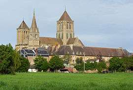 The abbey in Saint-Pierre-sur-Dives | |
 Saint-Pierre-en-Auge Location within Normandy region  Saint-Pierre-en-Auge | |
| Coordinates: 49°01′08″N 0°01′59″W / 49.019°N 0.033°WCoordinates: 49°01′08″N 0°01′59″W / 49.019°N 0.033°W | |
| Country | France |
| Region | Normandy |
| Department | Calvados |
| Arrondissement | Lisieux |
| Canton | Livarot |
| Intercommunality | CA Lisieux Normandie |
| Area1 | 144.97 km2 (55.97 sq mi) |
| Population (2014)2 | 7,794 |
| • Density | 54/km2 (140/sq mi) |
| Time zone | UTC+1 (CET) |
| • Summer (DST) | UTC+2 (CEST) |
| INSEE/Postal code | 14654 /14170 |
|
1 French Land Register data, which excludes lakes, ponds, glaciers > 1 km2 (0.386 sq mi or 247 acres) and river estuaries. 2 Population without double counting: residents of multiple communes (e.g., students and military personnel) only counted once. | |
Saint-Pierre-en-Auge is a commune in the department of Calvados, northwestern France. The municipality was established on 1 January 2017 by merger of the former communes of Saint-Pierre-sur-Dives (the seat), Boissey, Bretteville-sur-Dives, Hiéville, Mittois, Montviette, L'Oudon, Ouville-la-Bien-Tournée, Sainte-Marguerite-de-Viette, Saint-Georges-en-Auge, Thiéville, Vaudeloges and Vieux-Pont-en-Auge.[1]
See also
References
| Wikimedia Commons has media related to Saint-Pierre-en-Auge. |
- ↑ Arrêté préfectoral 19 December 2016 (in French)
This article is issued from
Wikipedia.
The text is licensed under Creative Commons - Attribution - Sharealike.
Additional terms may apply for the media files.