Mandeville-en-Bessin
| Mandeville-en-Bessin | |
|---|---|
| Commune | |
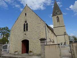 The church in Mandeville-en-Bessin | |
 Mandeville-en-Bessin Location within Normandy region  Mandeville-en-Bessin | |
| Coordinates: 49°18′08″N 0°52′38″W / 49.3022°N 0.8772°WCoordinates: 49°18′08″N 0°52′38″W / 49.3022°N 0.8772°W | |
| Country | France |
| Region | Normandy |
| Department | Calvados |
| Arrondissement | Bayeux |
| Canton | Trévières |
| Intercommunality | CC Isigny-Omaha Intercom |
| Government | |
| • Mayor (2008–2014) | Pierre Lefèvre |
| Area1 | 8.83 km2 (3.41 sq mi) |
| Population (2008)2 | 296 |
| • Density | 34/km2 (87/sq mi) |
| Time zone | UTC+1 (CET) |
| • Summer (DST) | UTC+2 (CEST) |
| INSEE/Postal code | 14397 /14710 |
| Elevation |
4–68 m (13–223 ft) (avg. 50 m or 160 ft) |
|
1 French Land Register data, which excludes lakes, ponds, glaciers > 1 km2 (0.386 sq mi or 247 acres) and river estuaries. 2 Population without double counting: residents of multiple communes (e.g., students and military personnel) only counted once. | |
Mandeville-en-Bessin is a commune in the Calvados department in the Normandy region in northwestern France.
Population
| Historical population | ||
|---|---|---|
| Year | Pop. | ±% |
| 1962 | 433 | — |
| 1968 | 368 | −15.0% |
| 1975 | 332 | −9.8% |
| 1982 | 305 | −8.1% |
| 1990 | 262 | −14.1% |
| 1999 | 229 | −12.6% |
| 2008 | 296 | +29.3% |
See also
References
| Wikimedia Commons has media related to Mandeville-en-Bessin. |
This article is issued from
Wikipedia.
The text is licensed under Creative Commons - Attribution - Sharealike.
Additional terms may apply for the media files.