Potigny
| Potigny | ||
|---|---|---|
| Commune | ||
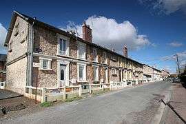 Miners' houses | ||
| ||
 Potigny Location within Normandy region  Potigny | ||
| Coordinates: 48°58′19″N 0°14′48″W / 48.9719°N 0.2467°WCoordinates: 48°58′19″N 0°14′48″W / 48.9719°N 0.2467°W | ||
| Country | France | |
| Region | Normandy | |
| Department | Calvados | |
| Arrondissement | Caen | |
| Canton | Falaise | |
| Intercommunality | Pays de Falaise | |
| Government | ||
| • Mayor (2008–2014) | Jean-Marie Gasnier | |
| Area1 | 4.26 km2 (1.64 sq mi) | |
| Population (2008)2 | 1,750 | |
| • Density | 410/km2 (1,100/sq mi) | |
| Time zone | UTC+1 (CET) | |
| • Summer (DST) | UTC+2 (CEST) | |
| INSEE/Postal code | 14516 /14420 | |
| Elevation | 125–206 m (410–676 ft) | |
|
1 French Land Register data, which excludes lakes, ponds, glaciers > 1 km2 (0.386 sq mi or 247 acres) and river estuaries. 2 Population without double counting: residents of multiple communes (e.g., students and military personnel) only counted once. | ||

Potigny is a commune in the Calvados department in the Normandy region in northwestern France.
Population
| Historical population | ||
|---|---|---|
| Year | Pop. | ±% |
| 1896 | 271 | — |
| 1901 | 239 | −11.8% |
| 1906 | 223 | −6.7% |
| 1911 | 451 | +102.2% |
| 1921 | 1,473 | +226.6% |
| 1926 | 1,731 | +17.5% |
| 1931 | 2,712 | +56.7% |
| 1936 | 2,420 | −10.8% |
| 1946 | 2,374 | −1.9% |
| 1954 | 2,694 | +13.5% |
| 1962 | 2,926 | +8.6% |
| 1968 | 2,720 | −7.0% |
| 1975 | 2,408 | −11.5% |
| 1982 | 2,155 | −10.5% |
| 1990 | 1,787 | −17.1% |
| 1999 | 1,703 | −4.7% |
| 2008 | 1,750 | +2.8% |
International relations
Potigny is twinned with the village of Banwell in Somerset.
See also
References
| Wikimedia Commons has media related to Potigny. |
This article is issued from
Wikipedia.
The text is licensed under Creative Commons - Attribution - Sharealike.
Additional terms may apply for the media files.