Longues-sur-Mer
| Longues-sur-Mer | ||
|---|---|---|
| Commune | ||
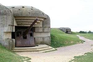 Two bunkers of the Longues-sur-Mer battery | ||
| ||
 Longues-sur-Mer Location within Normandy region  Longues-sur-Mer | ||
| Coordinates: 49°20′12″N 0°41′39″W / 49.3367°N 0.6942°WCoordinates: 49°20′12″N 0°41′39″W / 49.3367°N 0.6942°W | ||
| Country | France | |
| Region | Normandy | |
| Department | Calvados | |
| Arrondissement | Bayeux | |
| Canton | Bayeux | |
| Government | ||
| • Mayor (2008–2014) | Roland Tirard | |
| Area1 | 12.29 km2 (4.75 sq mi) | |
| Population (2008)2 | 674 | |
| • Density | 55/km2 (140/sq mi) | |
| Time zone | UTC+1 (CET) | |
| • Summer (DST) | UTC+2 (CEST) | |
| INSEE/Postal code | 14377 /14400 | |
| Elevation |
0–77 m (0–253 ft) (avg. 76 m or 249 ft) | |
|
1 French Land Register data, which excludes lakes, ponds, glaciers > 1 km2 (0.386 sq mi or 247 acres) and river estuaries. 2 Population without double counting: residents of multiple communes (e.g., students and military personnel) only counted once. | ||

Longues-sur-Mer is a commune in the Calvados department in Normandie region in northwestern France.
The Longues-sur-Mer battery is nearby, part of the Atlantic Wall coastal fortifications.
Population
| Historical population | ||
|---|---|---|
| Year | Pop. | ±% |
| 1962 | 4 | — |
| 1968 | 469 | +11625.0% |
| 1975 | 447 | −4.7% |
| 1982 | 463 | +3.6% |
| 1990 | 561 | +21.2% |
| 1999 | 586 | +4.5% |
| 2008 | 674 | +15.0% |
See also
References
External links
| Wikimedia Commons has media related to Longues-sur-Mer. |
| Authority control |
|---|
This article is issued from
Wikipedia.
The text is licensed under Creative Commons - Attribution - Sharealike.
Additional terms may apply for the media files.