Crouay
| Crouay | ||
|---|---|---|
| Commune | ||
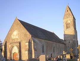 The church in Crouay | ||
| ||
 Crouay Location within Normandy region  Crouay | ||
| Coordinates: 49°16′05″N 0°48′22″W / 49.2681°N 0.8061°WCoordinates: 49°16′05″N 0°48′22″W / 49.2681°N 0.8061°W | ||
| Country | France | |
| Region | Normandy | |
| Department | Calvados | |
| Arrondissement | Bayeux | |
| Canton | Trévières | |
| Intercommunality | CC Isigny-Omaha Intercom | |
| Government | ||
| • Mayor (2008–2014) | Jean-Jacques Paul | |
| Area1 | 7.73 km2 (2.98 sq mi) | |
| Population (2008)2 | 529 | |
| • Density | 68/km2 (180/sq mi) | |
| Time zone | UTC+1 (CET) | |
| • Summer (DST) | UTC+2 (CEST) | |
| INSEE/Postal code | 14209 /14400 | |
| Elevation |
24–81 m (79–266 ft) (avg. 44 m or 144 ft) | |
|
1 French Land Register data, which excludes lakes, ponds, glaciers > 1 km2 (0.386 sq mi or 247 acres) and river estuaries. 2 Population without double counting: residents of multiple communes (e.g., students and military personnel) only counted once. | ||
Crouay is a commune in the Calvados department in the Normandy region in northwestern France.
International relations
Twin towns – Sister cities
Crouay is twinned with:

Population
| Historical population | ||
|---|---|---|
| Year | Pop. | ±% |
| 1962 | 383 | — |
| 1968 | 331 | −13.6% |
| 1975 | 352 | +6.3% |
| 1982 | 397 | +12.8% |
| 1990 | 444 | +11.8% |
| 1999 | 417 | −6.1% |
| 2008 | 529 | +26.9% |
See also
References
- ↑ "British towns twinned with French towns". Archant Community Media Ltd. Archived from the original on July 5, 2013. Retrieved 2013-07-11.
| Wikimedia Commons has media related to Crouay. |
This article is issued from
Wikipedia.
The text is licensed under Creative Commons - Attribution - Sharealike.
Additional terms may apply for the media files.