Saint-Pierre-Azif
| Saint-Pierre-Azif | |
|---|---|
| Commune | |
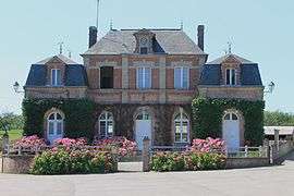 The town hall in Saint-Pierre-Azif | |
 Saint-Pierre-Azif Location within Normandy region  Saint-Pierre-Azif | |
| Coordinates: 49°17′45″N 0°02′35″E / 49.2958°N 0.0431°ECoordinates: 49°17′45″N 0°02′35″E / 49.2958°N 0.0431°E | |
| Country | France |
| Region | Normandy |
| Department | Calvados |
| Arrondissement | Lisieux |
| Canton | Pont-l'Évêque |
| Intercommunality | Cœur Côte Fleurie |
| Government | |
| • Mayor (2008–2014) | Xavier Duprez |
| Area1 | 6.17 km2 (2.38 sq mi) |
| Population (2008)2 | 163 |
| • Density | 26/km2 (68/sq mi) |
| Time zone | UTC+1 (CET) |
| • Summer (DST) | UTC+2 (CEST) |
| INSEE/Postal code | 14645 /14950 |
| Elevation |
40–139 m (131–456 ft) (avg. 81 m or 266 ft) |
|
1 French Land Register data, which excludes lakes, ponds, glaciers > 1 km2 (0.386 sq mi or 247 acres) and river estuaries. 2 Population without double counting: residents of multiple communes (e.g., students and military personnel) only counted once. | |
Saint-Pierre-Azif is a commune in the Calvados department in the Normandy region in northwestern France.
Population
| Historical population | ||
|---|---|---|
| Year | Pop. | ±% |
| 1962 | 204 | — |
| 1968 | 176 | −13.7% |
| 1975 | 145 | −17.6% |
| 1982 | 145 | +0.0% |
| 1990 | 158 | +9.0% |
| 1999 | 153 | −3.2% |
| 2008 | 163 | +6.5% |
See also
References
| Wikimedia Commons has media related to Saint-Pierre-Azif. |
Mentioned by author George Sand in her children's story "The Wings of Courage" (1872) as the home of the story's hero, Clopinet.
This article is issued from
Wikipedia.
The text is licensed under Creative Commons - Attribution - Sharealike.
Additional terms may apply for the media files.