Villers-Canivet
| Villers-Canivet | ||
|---|---|---|
| Commune | ||
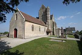 The church in Villers-Canivet | ||
| ||
 Villers-Canivet Location within Normandy region  Villers-Canivet | ||
| Coordinates: 48°56′28″N 0°15′15″W / 48.9411°N 0.2542°WCoordinates: 48°56′28″N 0°15′15″W / 48.9411°N 0.2542°W | ||
| Country | France | |
| Region | Normandy | |
| Department | Calvados | |
| Arrondissement | Caen | |
| Canton | Falaise | |
| Intercommunality | Pays de Falaise | |
| Government | ||
| • Mayor (2008–2014) | Jean-Louis Bonne | |
| Area1 | 12.24 km2 (4.73 sq mi) | |
| Population (2008)2 | 716 | |
| • Density | 58/km2 (150/sq mi) | |
| Time zone | UTC+1 (CET) | |
| • Summer (DST) | UTC+2 (CEST) | |
| INSEE/Postal code | 14753 /14420 | |
| Elevation |
139–233 m (456–764 ft) (avg. 170 m or 560 ft) | |
|
1 French Land Register data, which excludes lakes, ponds, glaciers > 1 km2 (0.386 sq mi or 247 acres) and river estuaries. 2 Population without double counting: residents of multiple communes (e.g., students and military personnel) only counted once. | ||
.svg.png)
Villers-Canivet is a commune in the Calvados department in the Normandy region in northwestern France.
Population
| Historical population | ||
|---|---|---|
| Year | Pop. | ±% |
| 1962 | 452 | — |
| 1968 | 460 | +1.8% |
| 1975 | 459 | −0.2% |
| 1982 | 476 | +3.7% |
| 1990 | 502 | +5.5% |
| 1999 | 497 | −1.0% |
| 2008 | 716 | +44.1% |
See also
References
| Wikimedia Commons has media related to Villers-Canivet. |
This article is issued from
Wikipedia.
The text is licensed under Creative Commons - Attribution - Sharealike.
Additional terms may apply for the media files.