Hérouvillette
| Hérouvillette | |
|---|---|
| Commune | |
 The washhouse in Hérouvillette | |
 Hérouvillette Location within Normandy region  Hérouvillette | |
| Coordinates: 49°13′21″N 0°14′34″W / 49.2225°N 0.2428°WCoordinates: 49°13′21″N 0°14′34″W / 49.2225°N 0.2428°W | |
| Country | France |
| Region | Normandy |
| Department | Calvados |
| Arrondissement | Lisieux |
| Canton | Cabourg |
| Intercommunality | Campagne et Baie de L'Orne |
| Government | |
| • Mayor (2008–2014) | Jean-François Bourdeau |
| Area1 | 4.00 km2 (1.54 sq mi) |
| Population (2008)2 | 1,098 |
| • Density | 270/km2 (710/sq mi) |
| Time zone | UTC+1 (CET) |
| • Summer (DST) | UTC+2 (CEST) |
| INSEE/Postal code | 14328 /14850 |
| Elevation |
8–45 m (26–148 ft) (avg. 30 m or 98 ft) |
|
1 French Land Register data, which excludes lakes, ponds, glaciers > 1 km2 (0.386 sq mi or 247 acres) and river estuaries. 2 Population without double counting: residents of multiple communes (e.g., students and military personnel) only counted once. | |
Hérouvillette is a commune in the Calvados department in the Normandy region in northwestern France.
Population
| Historical population | ||
|---|---|---|
| Year | Pop. | ±% |
| 1962 | 606 | — |
| 1968 | 810 | +33.7% |
| 1975 | 806 | −0.5% |
| 1982 | 765 | −5.1% |
| 1990 | 1,190 | +55.6% |
| 1999 | 1,119 | −6.0% |
| 2008 | 1,098 | −1.9% |
Places and monuments
- Hérouvillette: Church of the "Nativité-de-Notre-Dame" (XIV).
- Sainte-Honorine-la-Chardronnette: Church of Sainte-Honorine (XVIII).
- Lavoir on the "Aiguillon".
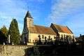 Church of the "Nativité-de-Notre-Dame".
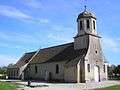 Church of Sainte-Honorine.
See also
References
| Wikimedia Commons has media related to Hérouvillette. |
This article is issued from
Wikipedia.
The text is licensed under Creative Commons - Attribution - Sharealike.
Additional terms may apply for the media files.