Saint-Pierre-Canivet
| Saint-Pierre-Canivet | ||
|---|---|---|
| Commune | ||
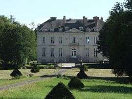 Chateau of la Tour | ||
| ||
 Saint-Pierre-Canivet Location within Normandy region  Saint-Pierre-Canivet | ||
| Coordinates: 48°55′53″N 0°13′07″W / 48.9314°N 0.2186°WCoordinates: 48°55′53″N 0°13′07″W / 48.9314°N 0.2186°W | ||
| Country | France | |
| Region | Normandy | |
| Department | Calvados | |
| Arrondissement | Caen | |
| Canton | Falaise | |
| Intercommunality | Pays de Falaise | |
| Government | ||
| • Mayor (2008–2014) | Jean-Pierre Goupil | |
| Area1 | 7.01 km2 (2.71 sq mi) | |
| Population (2008)2 | 365 | |
| • Density | 52/km2 (130/sq mi) | |
| Time zone | UTC+1 (CET) | |
| • Summer (DST) | UTC+2 (CEST) | |
| INSEE/Postal code | 14646 /14700 | |
| Elevation |
142–231 m (466–758 ft) (avg. 150 m or 490 ft) | |
|
1 French Land Register data, which excludes lakes, ponds, glaciers > 1 km2 (0.386 sq mi or 247 acres) and river estuaries. 2 Population without double counting: residents of multiple communes (e.g., students and military personnel) only counted once. | ||
.svg.png)
Saint-Pierre-Canivet is a commune in the Calvados department in the Normandy region in northwestern France.
Population
| Historical population | ||
|---|---|---|
| Year | Pop. | ±% |
| 1962 | 303 | — |
| 1968 | 334 | +10.2% |
| 1975 | 281 | −15.9% |
| 1982 | 338 | +20.3% |
| 1990 | 381 | +12.7% |
| 1999 | 342 | −10.2% |
| 2008 | 365 | +6.7% |
See also
References
| Wikimedia Commons has media related to Saint-Pierre-Canivet. |
This article is issued from
Wikipedia.
The text is licensed under Creative Commons - Attribution - Sharealike.
Additional terms may apply for the media files.