Perrières
| Perrières | |
|---|---|
| Commune | |
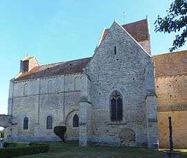 The church in Perrières | |
 Perrières Location within Normandy region  Perrières | |
| Coordinates: 48°57′36″N 0°08′06″W / 48.96°N 0.135°WCoordinates: 48°57′36″N 0°08′06″W / 48.96°N 0.135°W | |
| Country | France |
| Region | Normandy |
| Department | Calvados |
| Arrondissement | Caen |
| Canton | Falaise |
| Intercommunality | Pays de Falaise |
| Government | |
| • Mayor (2008–2014) | Danièle Blandin |
| Area1 | 8.17 km2 (3.15 sq mi) |
| Population (2008)2 | 276 |
| • Density | 34/km2 (87/sq mi) |
| Time zone | UTC+1 (CET) |
| • Summer (DST) | UTC+2 (CEST) |
| INSEE/Postal code | 14497 /14170 |
| Elevation |
42–136 m (138–446 ft) (avg. 74 m or 243 ft) |
|
1 French Land Register data, which excludes lakes, ponds, glaciers > 1 km2 (0.386 sq mi or 247 acres) and river estuaries. 2 Population without double counting: residents of multiple communes (e.g., students and military personnel) only counted once. | |
Perrières is a commune in the Calvados department in the Normandy region in northwestern France.
History
Around 1075, the Lord of Courcy founded a priory under the protection of the Marmoutier Abbey close to Tours.
Population
| Historical population | ||
|---|---|---|
| Year | Pop. | ±% |
| 1962 | 434 | — |
| 1968 | 378 | −12.9% |
| 1975 | 308 | −18.5% |
| 1982 | 269 | −12.7% |
| 1990 | 254 | −5.6% |
| 1999 | 252 | −0.8% |
| 2008 | 276 | +9.5% |
See also
References
| Wikimedia Commons has media related to Perrières. |
This article is issued from
Wikipedia.
The text is licensed under Creative Commons - Attribution - Sharealike.
Additional terms may apply for the media files.