Benerville-sur-Mer
| Bénerville-sur-Mer | ||
|---|---|---|
| Commune | ||
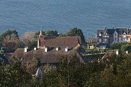 Benerville-sur-Mer seen from Mont Canisy | ||
| ||
 Bénerville-sur-Mer Location within Normandy region  Bénerville-sur-Mer | ||
| Coordinates: 49°20′35″N 0°02′14″E / 49.3431°N 0.0372°ECoordinates: 49°20′35″N 0°02′14″E / 49.3431°N 0.0372°E | ||
| Country | France | |
| Region | Normandy | |
| Department | Calvados | |
| Arrondissement | Lisieux | |
| Canton | Pont-l'Évêque | |
| Intercommunality | Cœur Côte Fleurie | |
| Government | ||
| • Mayor (2014–2020) | Jacques Marie | |
| Area1 | 3.03 km2 (1.17 sq mi) | |
| Population (2014)2 | 475 | |
| • Density | 160/km2 (410/sq mi) | |
| Time zone | UTC+1 (CET) | |
| • Summer (DST) | UTC+2 (CEST) | |
| INSEE/Postal code | 14059 /14910 | |
| Elevation |
2–111 m (6.6–364.2 ft) (avg. 112 m or 367 ft) | |
|
1 French Land Register data, which excludes lakes, ponds, glaciers > 1 km2 (0.386 sq mi or 247 acres) and river estuaries. 2 Population without double counting: residents of multiple communes (e.g., students and military personnel) only counted once. | ||
.svg.png)
Benerville-sur-Mer is a commune in the Calvados department and Normandy region of north-western France.
Population
| Historical population | ||
|---|---|---|
| Year | Pop. | ±% |
| 1946 | 341 | — |
| 1954 | 322 | −5.6% |
| 1962 | 314 | −2.5% |
| 1968 | 337 | +7.3% |
| 1975 | 361 | +7.1% |
| 1982 | 523 | +44.9% |
| 1990 | 411 | −21.4% |
| 1999 | 505 | +22.9% |
| 2007 | 494 | −2.2% |
| 2014 | 475 | −3.8% |
See also
References
| Wikimedia Commons has media related to Benerville-sur-Mer. |
This article is issued from
Wikipedia.
The text is licensed under Creative Commons - Attribution - Sharealike.
Additional terms may apply for the media files.