Time in the United States
Time in the United States, by law, is divided into nine standard time zones covering the states and its possessions, with most of the United States observing daylight saving time (DST) for approximately the spring, summer, and fall months. The time zone boundaries and DST observance are regulated by the Department of Transportation. Official and highly precise timekeeping services (clocks) are provided by two federal agencies: the National Institute of Standards and Technology (NIST) (an agency of the Department of Commerce); and its military counterpart, the United States Naval Observatory (USNO). The clocks run by these services are kept synchronized with each other as well as with those of other international timekeeping organizations.
It is the combination of the time zone and daylight saving rules, along with the timekeeping services, which determines the legal civil time for any U.S. location at any moment.
History
Prior to the adoption of four standard time zones for the continental United States, many towns and cities set their clocks to noon when the sun passed their local meridian, pre-corrected for the equation of time on the date of observation, to form local mean solar time. Noon occurred at different times but time differences between distant locations were barely noticeable prior to the 19th century because of long travel times and the lack of long-distance instant communications prior to the development of the telegraph.
The use of local solar time became increasingly awkward as railways and telecommunications improved.[1] American railroads maintained many different time zones during the late 1800s. Each train station set its own clock making it difficult to coordinate train schedules and confusing passengers. Time calculation became a serious problem for people travelling by train (sometimes hundreds of miles in a day), according to the Library of Congress. Every city in the United States used a different time standard so there were more than 300 local sun times to choose from. Time zones were therefore a compromise, relaxing the complex geographic dependence while still allowing local time to be approximate with mean solar time. Railroad managers tried to address the problem by establishing 100 railroad time zones, but this was only a partial solution to the problem.[1]
Operators of the new railroad lines needed a new time plan that would offer a uniform train schedule for departures and arrivals. Four standard time zones for the continental United States were introduced at noon on November 18, 1883, when the telegraph lines transmitted time signals to all major cities.[2]
In October 1884, the International Meridian Conference at Washington DC adopted a proposal which stated that the prime meridian for longitude and timekeeping should be one that passes through the centre of the transit instrument at the Greenwich Observatory in the United Kingdom (UK). The conference therefore established the Greenwich Meridian as the prime meridian and Greenwich Mean Time (GMT) as the world's time standard. The US time-zone system grew from this, in which all zones referred back to GMT on the prime meridian.[1]
From GMT to UTC
GMT was superseded as the international civil time standard by Coordinated Universal Time (UTC) in 1960, when the International Radio Consultative Committee formalized the concept of Coordinated Universal Time, abbreviated as UTC. It is, within about 1 second, mean solar time at 0°.[3] It does not observe daylight saving time. It is one of several closely related successors to Greenwich Mean Time (GMT). For most purposes, UTC is considered interchangeable with GMT, but GMT is no longer precisely defined by the scientific community.
United States time zones
Standard time zones in the United States are currently defined at the federal level by law 15 USC §260.[4] The federal law also establishes the transition dates and times at which daylight saving time occurs, if observed. It is ultimately the authority of the Secretary of Transportation, in coordination with the states, to determine which regions will observe which of the standard time zones and if they will observe daylight saving time.[5] As of August 9, 2007, the standard time zones are defined in terms of hourly offsets from UTC.[6] Prior to this they were based upon the mean solar time at several meridians 15° apart west of Greenwich (GMT).
Only the full-time zone names listed below are official; abbreviations are by common use conventions, and duplicated elsewhere in the world for different time zones.
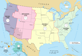
The United States uses nine standard time zones. As defined by US law[7] they are:
- The Atlantic standard time zone
- The Eastern standard time zone
- The Central standard time zone
- The Mountain standard time zone
- The Pacific standard time zone
- The Alaska standard time zone
- The Hawaii–Aleutian standard time zone
- The Samoa standard time zone
- The Chamorro standard time zone
View the standard time zone boundaries here.
Standard time and daylight saving time
Zones used in the contiguous U.S.
From east to west, the times zones of the contiguous United States are:
- The Eastern standard time zone: (Zone R), which comprises roughly the states on the Atlantic coast and the eastern two thirds of the Ohio Valley.
- The Central standard time zone: (Zone S), which comprises roughly the Gulf Coast, Mississippi Valley, and Great Plains.
- The Mountain standard time zone: (Zone T), which comprises roughly the states and portions of states that include the Rocky Mountains.
- The Pacific standard time zone: (Zone U), which comprises roughly the states on the Pacific coast, plus Nevada and the Idaho panhandle.
Zones used in states beyond the contiguous U.S.
- The Alaska standard time zone: (AKST; UTC−09:00; Zone V), which comprises most of the state of Alaska.
- The Hawaii-Aleutian standard time zone: (or unofficially Hawaii Standard Time) (HST; UTC−10:00; zone W), which includes Hawaii and most of the length of the Aleutian Islands chain (west of 169°30′W).
Zones outside the states
- The Samoa standard time zone (SST; UTC−11:00; Zone X), which comprises American Samoa.
- The Chamorro standard time zone: (ChST; UTC+10:00; Zone K), which comprises Guam and the Northern Mariana Islands.
- The Atlantic standard time zone: (AST; UTC-4:00; Zone Q), which comprises Puerto Rico and the US Virgin Islands.
Minor Outlying Islands
Some United States Minor Outlying Islands are outside the time zones defined by 15 U.S.C. §260 and exist in waters defined by Nautical time. In practice, military crews may simply use Zulu time (UTC±00:00) when on these islands. Baker Island and Howland Island are in UTC−12, while Wake Island is in UTC+12:00. Because they exist on opposite sides of the International Date Line, it can, for example, be noon Thursday on Baker and Howland islands while simultaneously being noon Friday on Wake Island. Other outlying islands include Jarvis Island, Midway Atoll, Palmyra Atoll, and Kingman Reef (UTC−11:00); Johnston Atoll (UTC−10:00); and Navassa Island, Bajo Nuevo Bank, and Serranilla Bank (UTC−05:00).
Antarctic research stations
In Antarctica, the US research facility Palmer Station is in UTC−03:00, while McMurdo Station and Amundsen–Scott South Pole Station use UTC+12:00 in order to coordinate with their main supply base in New Zealand.
Boundaries between the zones
(Described from north to south along each boundary.)
Eastern-Central boundary

- roughly follows the border between Wisconsin (to the south and west) and the Upper Peninsula of Michigan (to the north and east); the Upper Peninsula counties that border Wisconsin (namely Gogebic, Iron, Dickinson, and Menominee counties) observe CT, all other counties in the U.P. observe ET
- follows Lake Michigan
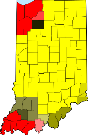
- divides a small portion of Northwestern Indiana near Chicago from the rest of the state
- follows the border between Illinois (west) and Indiana (east)
- divides a small portion of Southwestern Indiana from the rest of the state
- divides Kentucky in half roughly along a line that is west of Louisville, Kentucky running from northwest to southeast.
- divides the region legally defined as East Tennessee, except for four counties adjoining Middle Tennessee, from the rest of Tennessee.
- follows the border between Alabama (west) and Georgia (east), although Phenix City, Alabama and some nearby towns unofficially observe Eastern Time.
- divides the Florida Panhandle along the Apalachicola River and Intracoastal Waterway just west of Tallahassee, Florida.
Central-Mountain boundary
- divides the southwest portion of North Dakota from the rest of the state
- divides South Dakota roughly in half
- divides the western third of Nebraska from the rest of the state
- divides a very small portion of extreme western Kansas bordering Colorado (Greeley, Hamilton, Sherman, and Wallace counties) from the rest of the state (three other counties which border Colorado—Cheyenne, Morton, and Stanton counties—observe CST)
- follows the border between New Mexico (west) and Oklahoma (east) (although the zone legally begins at the Oklahoma–New Mexico state line, Kenton in extreme northwestern Cimarron County, Oklahoma unofficially observes MST)
- follows the border between New Mexico (west) and Texas (east)
- divides El Paso County, Hudspeth County, and a portion of northwestern Culberson County that includes eastern Guadalupe Mountains National Park from the rest of Texas
Mountain-Pacific boundary
- follows the border between northern Idaho (to the west) and northwestern Montana (to the east)
- turns west at 45°33.46′N 114°33.89′W / 45.55767°N 114.56483°W (just south of Nez Perce Pass), and follows the Idaho County line to the Salmon River
- follows the Salmon River west to the town of Riggins, where the Salmon River turns north. This puts almost all of northern Idaho in the Pacific time zone, except for the small loop described next.
- turns north and follows the Salmon River to the Snake River at the Oregon border (at 45°51.3′N 116°47.5′W / 45.8550°N 116.7917°W). This loop to the north creates a curious situation where one can enter a more-westerly time zone by traveling east over one of the bridges across this portion of the Salmon River.
- turns south and follows the Snake River between Oregon (west) and Idaho (east) to the northern border of Malheur County, Oregon
- turns west and follows the northern border of Malheur County, Oregon to its western border, where it turns south
- follows the western border of Malheur County to latitude 42.45° (42°27′ N), where it turns east, and returns to the Oregon/Idaho border
- turns south and follows the border between Oregon (west) and Idaho (east)
- turns east and follows the border between Idaho (north) and Nevada (south) along the 42nd parallel north to longitude 114.041726 W.
- turns south and follows the border between Nevada (west) and Utah (east), except for following the west city limit line of West Wendover dividing it from the rest of Nevada, and putting it in the Mountain Time Zone. Jackpot, Nevada, just south of the 42nd parallel and some 25 miles (40 km) west of the time zone south turn, also observes Mountain Time, on an unofficial basis.
- follows the border between Nevada (west) and Arizona (east)
- follows the border between California (west) and Arizona (east), mostly defined by the Colorado River, to the border between the U.S. and Mexico.
Daylight saving time
The Energy Policy Act of 2005 extended daylight saving time (DST) for an additional month beginning in 2007. The start of DST now occurs on the second Sunday in March and ends on the first Sunday in November.
Clocks will be set ahead one hour at 2 a.m. on the following start dates and set back one hour at 2 a.m. on these ending dates:
| Year | Start date | Ending date |
|---|---|---|
| 2006 | April 2 | October 29 |
| 2007 | March 11 | November 4 |
| 2008 | March 9 | November 2 |
| 2009 | March 8 | November 1 |
| 2010 | March 14 | November 7 |
| 2011 | March 13 | November 6 |
| 2012 | March 11 | November 4 |
| 2013 | March 10 | November 3 |
| 2014 | March 9 | November 2 |
| 2015 | March 8 | November 1 |
| 2016 | March 13 | November 6 |
| 2017 | March 12 | November 5 |
| 2018 | March 11 | November 4 |
| 2019 | March 10 | November 3 |
| 2020 | March 8 | November 1 |
In response to the Uniform Time Act of 1966, each state of the US has officially chosen to apply one of two rules over its entire territory:
- Most use the standard time for their zone (or zones, where a state is divided between two zones), except for using daylight saving time during the summer months. Originally this ran from the last Sunday in April until the last Sunday in October. Two subsequent amendments, in 1986 and 2005, have shifted these days so that daylight saving time now runs from the second Sunday in March until the first Sunday in November.
 Arizona time zones
 - Arizona and Hawaii use standard time throughout the year. However:
- The Navajo Nation observes DST throughout its entire territory, including the portion that lies in Arizona. But the Hopi Nation, which is entirely surrounded by the Navajo Nation and is entirely in Arizona, does not observe DST. (See map inset right.)
- In 2005, Indiana passed legislation which took effect on April 2, 2006, that placed the entire state on daylight saving time (see Time in Indiana). Before then, Indiana officially used standard time year-round, with the following exceptions:
- The portions of Indiana that were on Central Time observed daylight saving time.
- Also, some Indiana counties near Cincinnati and Louisville were on Eastern Time, but did (unofficially) observe DST.
Time representation
There exist more than one hundred clock towers in the United States; see Category:Clock towers in the United States.
See also
References
- 1 2 3 "Why Do We Have Time Zones?".
- ↑ What is Greenwich Mean Time (GMT) http://wwp.greenwichmeantime.com/info/gmt.htm
- ↑ Bernard Guinot, "Solar time, legal time, time in use" Metrologica, August 2011 (volume 48, issue 4), pages 181–185.
- ↑ 15 USC §260.
- ↑ "15 U.S. Code Subchapter IX - STANDARD TIME".
- ↑ Public Law 110–69 — America COMPETES Act (August 9, 2007). Sec. 3013)
- ↑ Standard Time Zone Boundaries 49CFR71
- ↑ ""What are the time zones in the United States?"". National Institute of Standards and Technology, U.S. Department of Commerce. May 18, 2018. Retrieved August 6, 2018.
Hawaii-Aleutian (HT); HST -10; HDT -9; DST observed in Aleutian Islands, but not Hawaii
External links
- Official website
- U.S. Navy time zone page
- North American Time Zone border data and images
- CFR's Title 40 - Protection of Environment (also at wikisource:Code of Federal Regulations/Title 49/Subtitle A/Part 71)
- Standard Time Law 15USC260-267 (also at wikisource:United States Code/Title 15/Chapter 6/Subchapter IX)
Time in the Americas | ||
|---|---|---|
| ||
| Sovereign states |
| .svg.png) |
| ||