Portage, Indiana
| Portage, Indiana | ||
|---|---|---|
| City | ||
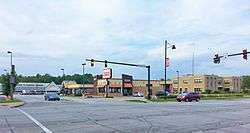 Downtown Portage | ||
| ||
| Nickname(s): The Port City/The Port of Opportunity | ||
 Location of Portage in Porter County, Indiana. | ||
| Coordinates: 41°34′55″N 87°11′12″W / 41.58194°N 87.18667°WCoordinates: 41°34′55″N 87°11′12″W / 41.58194°N 87.18667°W | ||
| Country | United States | |
| State | Indiana | |
| County | Porter | |
| Township | Portage | |
| Government | ||
| • Type | Strong Mayor-Council | |
| • Mayor | James Snyder (R) | |
| • Clerk-Treasurer | Christopher Stidham (D) | |
| • City Council | ||
| Area[1] | ||
| • Total | 27.61 sq mi (71.51 km2) | |
| • Land | 25.52 sq mi (66.09 km2) | |
| • Water | 2.10 sq mi (5.43 km2) | |
| Elevation[2] | 636 ft (194 m) | |
| Population (2010)[3] | ||
| • Total | 36,828 | |
| • Estimate (2017)[4] | 36,672 | |
| • Density | 1,430.67/sq mi (552.39/km2) | |
| Time zone | UTC−6 (CST) | |
| • Summer (DST) | UTC−5 (CDT) | |
| ZIP code | 46368 | |
| Area code(s) | 219 | |
| FIPS code | 18-61092[5] | |
| GNIS feature ID | 449815 | |
| Website | http://www.ci.portage.in.us | |
| Historical population | |||
|---|---|---|---|
| Census | Pop. | %± | |
| 1950 | 2,116 | — | |
| 1960 | 11,822 | 458.7% | |
| 1970 | 19,127 | 61.8% | |
| 1980 | 27,409 | 43.3% | |
| 1990 | 29,060 | 6.0% | |
| 2000 | 33,496 | 15.3% | |
| 2010 | 36,828 | 9.9% | |
| Est. 2017 | 36,672 | [4] | −0.4% |
| Source: US Census Bureau | |||
Portage /ˈpɔːrtɪdʒ/ is a city in Portage Township, Porter County, in the U.S. state of Indiana.[6] The population was 36,828 as of the 2010 census. It is the largest city in Porter County, and third largest in Northwest Indiana.
History
Pre-European settlement
Previous to European settlers arriving, Native American Indians lived in the area now known as Portage, Indiana. The first known group was the Mound Builders. The only known mound existed in the village of McCool. This mound was removed by the owner, Mr. J.S. Robbins in the early 1900s. Following the Mound Builders, the Wea Tribe inhabited the area. The Wea were forced south of the area by the Potawatomi Tribe.[7]
Early explorers and settlers
It is speculated that Marquette, Joliet, Hennepin or De la Croix was the first explorer, however it is unknown exactly who it was.[7] Despite the Potawatomi being a warring tribe, Chief Pokagon encouraged diplomacy rather than war when European Settlers wanted to settle in the area. The Potawatomi tribe sold land to the settlers in 1812 known as Garyton which was one of the first communities in Portage Township.[8]
By 1833, there were many European settlers in the area. Samuel Putnam Robbins was among the first. He came from Hocking County, Ohio, and settled near modern-day Robbins Road between McCool Road and Indiana Highway 149. In 1834, Joseph Wolf, who was married to a Blake settled in the area, squatted on land currently near the modern-day community of South Haven [7] and operated several dairy and beef farms there.[9] Other known early settlers include Berret Door, Reuben Hurlburt, Wilford Parrott, The Spurloch brothers, William McCool, Benjamin James, his son Allen James, William Holmes and Jacob Blake. Jacob Blake came to Portage in 1833.The following family names are also among the first settlers: Blake, Palmer, Summer, Ritter, Curtis, Peck, Hurl, Lenburg, Fifield, Crisman, Krieger, Nicholson, Samuelson, Swanson, Lute, Hamstrom, McCool, and Wolfe.[7][8]
Early communities
Before Portage became a town, it consisted primarily of three separate communities in addition to much farmland. They were named McCool, Crisman and Garyton. In 1950, those communities only had 2,116 residents. La Porte County maintained jurisdiction over Porter County in 1835, and founded Portage Township that year.[9]
Railroads
Portage Township was primarily a farming community until railroad development began in the 1850s and 1860s. The first railroad to build in the area was the Michigan Central, completed in 1852. The Michigan Central connected Detroit to Chicago. This enabled local farmers to easily ship livestock, dairy and crops to Chicago and any other stop along the way. It was a boon to the farmers of the area at the time and enabled them to buy more land for farming.[9] The Michigan Central was later bought by the New York Central Railroad.[8]
The next railroad to build through the Portage area was the Baltimore and Ohio in 1874. This railroad crossed the Michigan Central near the village of Crisman. Despite the apparent success of the early railroads, the area remained primarily agrarian and relied on the railroads to sustain its economy. Sand was also an industry in Portage due to demand in the growing city of Chicago. The railroads enabled sand to be delivered to Chicago more efficiently.[9]
Depression era and War
Between the 1870s and the depression era, Portage did not grow very much. It has been estimated that between 1880 and 1950, the growth rate averaged only about 64 people per year. This is despite the growth of towns to the west such as Gary, Hammond and East Chicago due to the industrialization of steel mills. Portage was not unaffected by the Great Depression. Due to the steel mills being in economic trouble, the farmers of Portage did not have demand to produce their products. As a result of this, the farmers had food, but no money. Many even lost their farms.
Like many communities in the country, World War I and World War II affected the economy of Portage in a big way. Steel mills geared into high production and labor was in high demand, thus drawing many people to the area.[9]
Post-World War II
After the war, the economy remained strong because of the high demand for automobiles and appliances, both of which the steel was produced at the steel mills. The population of post-war Portage grew very quickly. In the early 1950s, people came from Kentucky, southern Indiana and Illinois. Most were seeking the steady salary available in the steel mills and related industries.
National Steel opened a plant along the shore of Lake Michigan in Portage in 1959. This brought in about 1,600 new jobs. The Port of Indiana was also built in 1961 to accommodate trade with the world via Lake Michigan. In 1963, Bethlehem Steel began construction of a plant which was located partly in Portage. This project brought about 6,000 jobs to the area.
In 1959, Portage was incorporated as a town. Ogden Dunes and South Haven were excluded because the residents of these areas did not wish to be included in the town. Due to the surge of population after the war, many farmers were selling land to be subdivided into lots for families to build homes. In 1967, Portage officially became a city. During the 1950s and 1960s, the city of Gary was going through a time of racial strife. White people of Gary were seeking a way out of the turmoil, which drew many people to Portage during this time.[9]
Present day
Portage is still a heavily industrial city. While primarily dependent on the Steel Industry, the 1980s brought a decline in the steel industry. As a result, C.O.I.L (the Community Organization on Industrial Location) was formed. This organization promotes diversified industry in the area. They have had part in developing the Coca-Cola bottling plant and further development of the Port of Indiana.
Very few farms are still active in the Portage area. However, many original descendants of founding families are still in the area.[9]
Portage has seen many new green technology industries locate to the community since the early 2000s including Fronius USA. In 2016, the City opened a new Police Station and Fire Station in the downtown corridor. The new Police Station is triple the size of the former station on Irving Street.
Geography
Portage is located at 41°34′55″N 87°11′12″W / 41.581850°N 87.186553°W (41.581850, −87.186553).[10]
According to the 2010 census, Portage has a total area of 27.614 square miles (71.52 km2), of which 25.63 square miles (66.38 km2) (or 92.82%) is land and 1.984 square miles (5.14 km2) (or 7.18%) is water.[11]
Demographics
2010 census
As of the census[3] of 2010, there were 36,828 people, 13,992 households, and 9,751 families residing in the city. The population density was 1,436.9 inhabitants per square mile (554.8/km2). There were 14,807 housing units at an average density of 577.7 per square mile (223.1/km2). The racial makeup of the city was 83.6% White, 7.3% African American, 0.4% Native American, 0.9% Asian, 5.2% from other races, and 2.6% from two or more races. Hispanic or Latino of any race were 16.4% of the population.
There were 13,992 households of which 36.3% had children under the age of 18 living with them, 49.0% were married couples living together, 14.6% had a female householder with no husband present, 6.1% had a male householder with no wife present, and 30.3% were non-families. 24.3% of all households were made up of individuals and 9% had someone living alone who was 65 years of age or older. The average household size was 2.61 and the average family size was 3.10.
The median age in the city was 36.4 years. 25.7% of residents were under the age of 18; 8.5% were between the ages of 18 and 24; 27.5% were from 25 to 44; 26.2% were from 45 to 64; and 12.1% were 65 years of age or older. The gender makeup of the city was 48.4% male and 51.6% female.
2000 census
As of the census[5] of 2000, there were 33,496 people, 12,746 households, and 9,011 families residing in the city. The population density was 1,315.8 people per square mile (508.0/km2). There were 13,375 housing units at an average density of 525.4 per square mile (202.8/km2). The racial makeup of the city was 92.52% White, 1.45% African American, 0.27% Native American, 0.64% Asian, 0.06% Pacific Islander, 3.20% from other races, and 1.86% from two or more races. Hispanic or Latino of any race were 9.94% of the population.
There were 12,746 households out of which 34.7% had children under the age of 18 living with them, 53.7% were married couples living together, 12.2% had a female householder with no husband present, and 29.3% were non-families. 23.9% of all households were made up of individuals and 9.1% had someone living alone who was 65 years of age or older. The average household size was 2.60 and the average family size was 3.09.
In the city, the population was spread out with 26.0% under the age of 18, 9.4% from 18 to 24, 29.9% from 25 to 44, 22.8% from 45 to 64, and 11.8% who were 65 years of age or older. The median age was 35 years. For every 100 females, there were 94.2 males. For every 100 females age 18 and over, there were 91.0 males.
The median income for a household in the city was $47,500, and the median income for a family was $54,316. Males had a median income of $46,224 versus $25,428 for females. The per capita income for the city was $20,146. About 5.8% of families and 7.5% of the population were below the poverty line, including 10.6% of those under age 18 and 5.6% of those age 65 or over.
Transportation
The commercial airport nearest Portage is the Gary/Chicago International Airport in Gary. Chicago's O'Hare International Airport and Chicago Midway International Airport are also in close proximity and provide the bulk of flights servicing Portage.
Coach USA's Tri State/United Limo service stops at Central & Irving intersection, connecting Portage to Chicago's airports and several other North Indiana cities and town. Riders can take westbound buses to Highland, Crestwood and O'Hare and Midway Airport and eastbound buses to Michigan City, South Bend and Notre Dame. Buses run between Westbound buses run every hour. Eastbound buses to Michigan City run every hour while eastbound buses to South Bend and Notre Dame run every two hours.[12]
Portage is also connected to Chicago, Illinois and South Bend, Indiana by the South Shore Line. Passengers can board the train at the Portage/Ogden Dunes Station, which is located immediately east of Ogden Dunes in Portage.
Portage is intersected by several major highways, including Interstate 94 and Interstates 80/90 (Indiana Toll Road) as well as U.S. Route 6, U.S. Route 12, U.S. Route 20, and Indiana 149 and Indiana 249.
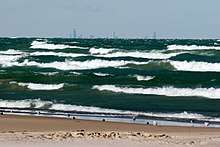
Also located on the shores of Lake Michigan is the Port of Indiana.
Politics
Portage has a Strong Mayor-Council government. The current Mayor is James Snyder (R), who took office on January 1, 2012. Snyder was re-elected to a second term in 2015 defeating current Portage Township Trustee and former City Council member Brendan Clancy. Snyder had succeeded Olga Velazquez (D) who served one term in office. Velazquez had defeated Snyder in the 2007 election.
Douglas Olson served two terms as Mayor, defeating incumber Mayor Sammie Maletta in the Democratic Primary in 1999 and faced no opposition in the General Election. He was re-elected in 2003 with no opposition. Doug Olson is the son of Portage's first Mayor, Arthur Olson. Doug Olson is also the only person to serve in all three elected City offices as a City Councilman, Clerk-Treasurer and Mayor.
Mayor Sammie Maletta was the only Mayor to serve three consecutive terms in office. Maletta was first elected in 1987 and subsequently reelected in 1991 and 1995. He lost his bid for an historic fourth term in the 1999 Democratic Primary to then Porter County Circuit Court Clerk and former Portage Clerk-Treasurer and City Councilman, Douglas Olson.
Robert Goin was the City's only Republican Mayor, prior to the election of the current Mayor James Snyder, served two consecutive terms from 1972 to 1979. Goin also served an additional non-consecutive third term from 1984 to 1987.
Current Members of the City Council
| District | Council Member | First Took Office | Political Party |
|---|---|---|---|
| 1 | Elizabeth Modesto | 1996 | Democratic |
| 2 | Patrick Clem | 2010 | Democratic |
| 3 | Scott Williams | 2016 | Democratic |
| 4 | John Cannon | 2012 | Republican |
| 5 | Collin Czilli | 2016 | Democratic |
| At-Large | Suzanne Lynch | 2008 | Democratic |
| At-Large | Mark Oprisko | 2012 | Democratic |
List of Mayors
| Mayor | Term Began | Term Ended | Political Party |
|---|---|---|---|
| Arthur Olson | 1968 | 1971 | Democratic |
| Robert Goin | 1972 | 1979 | Republican |
| John Williams | 1980 | 1983 | Democratic |
| Robert Goin | 1984 | 1987 | Republican |
| Sammie Maletta | 1988 | 1999 | Democratic |
| Doug Olson | 2000 | 2007 | Democratic |
| Olga Velazquez | 2008 | 2011 | Democratic |
| James Snyder | 2012 | Present | Republican |
Education
Public schools
The Portage Township School system comprises 11 public schools: 8 elementary schools (grades K-5), 2 middle schools (grades 6-8), and one senior high school (grades 9-12). Portage Township Schools is an Indiana Exemplary District and has two Four Star schools in the district.[13]
| Elementary Schools | Middle Schools | Senior High School |
|---|---|---|
| Aylesworth | Fegely | Portage High School |
| Central | Willowcreek | |
| Crisman | ||
| Jones | ||
| Kyle | ||
| Myers | ||
| Saylor | ||
| South Haven |
Private schools
There are 2 private schools in Portage:
- Portage Christian School - A Christian school servicing children in grades Pre-K - 12
- Nativity of Our Savior School - A Roman Catholic school servicing children in grades Pre-K-8
There was a third private school, Marantha Christian Academy, but it is now closed.[14]
Public library
Portage has a public library, a branch of the Porter County Public Library System.[15]
Local media
Newspapers
- The Times of Northwest Indiana (or NWI Times), was founded in 1906 and is the second largest of Indiana’s 76 daily newspapers.
- The Post-Tribune of Northwest Indiana was founded in 1907, serving the Northwest Indiana region. The Post-Tribune is owned by the Sun Times Media Group.
Magazines
- Shore Magazine is a magazine produced by the NWI Times, which also produces ShoreLines, a weekly newsletter.
Websites
- PortageLife.com, a website launched in early 2010, which publishes information about community and city events and initiatives for Portage, Indiana.
- Greater Portage Chamber of Commerce Website is a website provided by the Greater Portage Chamber of commerce for residents living, visiting, or moving to Portage.
References
- ↑ "2016 U.S. Gazetteer Files". United States Census Bureau. Retrieved Jul 28, 2017.
- ↑ "US Board on Geographic Names". United States Geological Survey. 2007-10-25. Retrieved 2008-01-31.
- 1 2 "American FactFinder". United States Census Bureau. Retrieved 2012-12-11.
- 1 2 "Population and Housing Unit Estimates". Retrieved June 9, 2017.
- 1 2 "American FactFinder". United States Census Bureau. Retrieved 2008-01-31.
- ↑ "Portage, Indiana". Geographic Names Information System. United States Geological Survey. Retrieved 2017-04-02.
- 1 2 3 4 Dorris, Joyce. "Weaving the Past into the Future." Steel Shavings Volume 20 (1991): 3
- 1 2 3 Norman, Dennis, and James Wright. Images of America Portage Township. Chicago: Arcadia, 2003.
- 1 2 3 4 5 6 7 Sawochka, Bruce. "Portage in Three Stages of its Growth." Steel Shavings Volume 20 (1991): 4-6
- ↑ "US Gazetteer files: 2010, 2000, and 1990". United States Census Bureau. 2011-02-12. Retrieved 2011-04-23.
- ↑ "G001 - Geographic Identifiers - 2010 Census Summary File 1". United States Census Bureau. Retrieved 2015-07-29.
- ↑ http://www.coachusa.com/CoachUsaAssets/files/113/schedule.pdf
- ↑ "Portage Township Schools / Overview". portage.k12.in.us. Archived from the original on 13 May 2015. Retrieved 17 May 2015.
- ↑ "PORTAGE IN Private Schools". allprivateschools.org. Retrieved 17 May 2015.
- ↑ "Locations". Porter County Public Library System. Retrieved 14 March 2018.
External links
- Porter County Public Library System
- Portage Economic Development Corporation Website
- Portage Community Website
- History of Portage- Encyclopedia of Chicago
Municipalities and communities of Porter County, Indiana, United States | ||
|---|---|---|
| Cities | ||
| Towns | ||
| Townships | ||
| CDPs | ||
| Other unincorporated communities | ||
| Ghost towns | ||
| Footnotes | ‡This populated place also has portions in an adjacent county or counties | |
| Major city |  | |
|---|---|---|
| Cities (over 30,000 in 2010) | ||
| Towns and villages (over 30,000 in 2010) |
| |
| Counties | ||
| Regions | ||
| Sub-regions | ||
