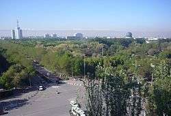
Shihezi
Shihezi is a sub-prefecture-level city in Northern Xinjiang, People's Republic of China. It has a population of 380,130 according to the 2010 census.
Shihezi 石河子市 شىخەنزە شەھىرى | |
|---|---|
County-level & Sub-prefectural city | |
 Shihezi | |
 Shihezi Location in Xinjiang | |
| Coordinates: 44°18′19″N 86°04′49″E | |
| Country | People's Republic of China |
| Region | Xinjiang |
| Government | |
| • CPC Shihezi | Committee Secretary |
| Area | |
| • Total | 460 km2 (180 sq mi) |
| Population | |
| • Total | 640,000 |
| • Density | 1,400/km2 (3,600/sq mi) |
| Time zone | UTC+8 (China Standard) |
| Postal code | 832000 |
| Area code(s) | 0993 |
| Shihezi | |||||||||||
|---|---|---|---|---|---|---|---|---|---|---|---|
| Chinese name | |||||||||||
| Chinese | 石河子 | ||||||||||
| Literal meaning | Stony river banks | ||||||||||
| |||||||||||
| Uyghur name | |||||||||||
| Uyghur | شىخەنزە | ||||||||||
| |||||||||||
History
In 1951, General Wang Zhen decided to build a new base for the People's Liberation Army and selected the place of current Shihezi. Zhao Xiguang (赵锡光) took charge in the development of the city and established the Xinjiang Production and Construction Corps in 1954.
Farms surrounding Shihezi fueled the development of the city. These quasi-military-structured farms produce materials for the factories that have been the economic drivers of the city. In 1974, Shihezi became a city.
Demographics
Over 90% of Shihezi's population are Han Chinese, with smaller number of Hui, Uighurs, Kazakhs and various other minorities.
- Population by ethnicity – 2010 census[2]
| Ethnicity | Population | % |
|---|---|---|
| Han | 349,149 | 91.85% |
| Hui | 15,092 | 3.97% |
| Uyghur | 7,574 | 1.99% |
| Kazakhs | 3,042 | 0.80% |
| Tujia | 1,500 | 0.39% |
| Mongol | 624 | 0.16% |
| Manchu | 620 | 0.16% |
| Kyrgyz | 319 | 0.08% |
| Dongxiang | 306 | 0.08% |
| Xibe | 157 | 0.04% |
| Russian | 138 | 0.04% |
| Others | 1,609 | 0.43% |
| Total | 380,130 | 100% |
Economy
Nowadays textile and food industries are the most important in Shihezi. The railway to Wusu and Ürümqi skirts the city, while a United Nations economic development project provided a high-quality highway system for the city. The textile industry is the primary employer, although the international trade environment on textiles has brought in fluctuations in employment. As a hub to surrounding farms, the city's destiny is currently tied with theirs. Sugar beets are cultivated near Shihezi. Cultivation of cotton in the farms was accelerated in the 1990s and now dominates the economy.[3]
Geography and climate
Shihezi is located at the northern foothills of the middle part of the Tian Shan range approximately 136 kilometres (85 mi) from the regional capital of Ürümqi.
Although Shihezi is almost surrounded on the east, west and north by the Changji Hui Autonomous Prefecture (which also includes the city's eastern neighbor, the much older historically Hui town of Manas), it is not a part of it.
Located in an area further from the nearest seacoast than any other region on earth, Shihezi has a continental semi-arid climate (Köppen BSk), with a large temperature differences between summer and winter. Monthly average temperatures range from −15.3 °C (4.5 °F) in January to 25.3 °C (77.5 °F), and the annual mean temperature is 7.39 °C (45.3 °F). Precipitation is very low year-round, with an annual total of only 206 millimetres (8.11 in), compared to the annual evaporation rate, which is usually more than 1,000 millimetres (39 in).[4]
| Climate data for Shihezi (1971−2000) | |||||||||||||
|---|---|---|---|---|---|---|---|---|---|---|---|---|---|
| Month | Jan | Feb | Mar | Apr | May | Jun | Jul | Aug | Sep | Oct | Nov | Dec | Year |
| Record high °C (°F) | 7.6 (45.7) |
6.6 (43.9) |
22.7 (72.9) |
35.4 (95.7) |
37.4 (99.3) |
39.2 (102.6) |
42.2 (108.0) |
41.0 (105.8) |
39.4 (102.9) |
33.3 (91.9) |
17.5 (63.5) |
8.3 (46.9) |
42.2 (108.0) |
| Average high °C (°F) | −10 (14) |
−6.3 (20.7) |
4.7 (40.5) |
19.3 (66.7) |
26.3 (79.3) |
30.9 (87.6) |
32.8 (91.0) |
31.4 (88.5) |
25.4 (77.7) |
15.5 (59.9) |
3.0 (37.4) |
−6.9 (19.6) |
13.8 (56.8) |
| Daily mean °C (°F) | −15.3 (4.5) |
−11.6 (11.1) |
−0.1 (31.8) |
12.1 (53.8) |
18.8 (65.8) |
23.6 (74.5) |
25.3 (77.5) |
23.3 (73.9) |
17.2 (63.0) |
8.2 (46.8) |
−1.7 (28.9) |
−11.1 (12.0) |
7.4 (45.3) |
| Average low °C (°F) | −20.8 (−5.4) |
−17 (1) |
−4.9 (23.2) |
5.0 (41.0) |
11.2 (52.2) |
16.0 (60.8) |
17.7 (63.9) |
15.2 (59.4) |
9.4 (48.9) |
1.8 (35.2) |
−5.7 (21.7) |
−15.5 (4.1) |
1.0 (33.8) |
| Record low °C (°F) | −34.4 (−29.9) |
−36.5 (−33.7) |
−30.5 (−22.9) |
−19.4 (−2.9) |
−0.2 (31.6) |
6.6 (43.9) |
9.6 (49.3) |
3.5 (38.3) |
−0.5 (31.1) |
−8.9 (16.0) |
−28.9 (−20.0) |
−36.0 (−32.8) |
−36.5 (−33.7) |
| Average precipitation mm (inches) | 8.6 (0.34) |
8.4 (0.33) |
12.5 (0.49) |
26.2 (1.03) |
29.9 (1.18) |
21.0 (0.83) |
21.5 (0.85) |
15.1 (0.59) |
15.9 (0.63) |
18.9 (0.74) |
16.8 (0.66) |
11.2 (0.44) |
206.0 (8.11) |
| Average precipitation days (≥ 0.1 mm) | 8.4 | 6.6 | 6.0 | 6.1 | 7.2 | 8.1 | 9.1 | 5.9 | 5.0 | 5.2 | 6.2 | 9.0 | 82.8 |
| Source: Weather China[4] | |||||||||||||
The Manas River forms the administrative border between Shihezi City and its eastern neighbor, Manas County. An extensive system of reservoirs (such as the Jiahezi Reservoir (夹河子水库; Jiāhézi shuǐkù, with the dam at 44°27′00″N 86°7′15″E) and irrigation canals has been constructed in the area, supporting irrigated agriculture.
Education
Shihezi University is located in Shihezi. It is the second-largest university in Xinjiang, with approximately 40,000 students.
Transport
Shihezi is served by China National Highway 312, the Northern Xinjiang and the Second Ürümqi-Jinghe Railways. Reconstruction of the Shihezi Airport began in May 2012 and the airport is expected to reopen in 2014.
References
- Copyright by Yingkou People
- Stanley W. Toops (August 2012). Susan M. Walcott, Corey Johnson (eds.). Eurasian Corridors of Interconnection: From the South China to the Caspian Sea. Routledge. pp. 65–66. ISBN 978-1135078751.CS1 maint: uses editors parameter (link)
- Shihezi a 'Shining Pearl in the Gobi Desert' (China.org.cn by staff reporter Wang Qian, October 3, 2004)
- 石河子城市介绍 (in Chinese). Weather China. Retrieved 2011-11-29.