Xiangyang
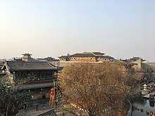
Xiangyang is a prefecture-level city in northwestern Hubei province, China and the second largest city in Hubei by population. It was known as Xiangfan from 1950 to 2010.[3] The Han River runs through Xiangyang's centre and divides the city north–south. The city itself is an agglomeration of two once separate cities: Fancheng and Xiangcheng (known as Xiangfan before 2010). What remains of old Xiangyang is located south of the Han River and contains one of the oldest still-intact city walls in China, while Fancheng is located to the north of the Han River. Both cities served prominent historical roles in both ancient and pre-modern Chinese history. Today, the city has been a target of government and private investment as the country seeks to urbanize and develop the interior provinces. In 2017, population of the prefecture-level city was 5.65 million, in which 3.37 million were urban residents.[4]
Xiangyang 襄阳市 Siangyang, Siang-yang | |
|---|---|
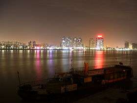 Overlooking Fancheng District from Xiangcheng District on the other side of the Han River. | |
.png) Location of Xiangyang City jurisdiction in Hubei | |
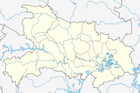 Xiangyang Location of the city centre in Hubei | |
| Coordinates (Xiangyang municipal government): 32°00′36″N 112°07′19″E | |
| Country | People's Republic of China |
| Province | Hubei |
| County-level divisions | 8 |
| Township-level divisions | 159 |
| Municipal seat | Xiangcheng District |
| Area | |
| • Prefecture-level city | 19,724.41 km2 (7,615.64 sq mi) |
| • Urban (2017)[1] | 374.30 km2 (144.52 sq mi) |
| • Districts[1] | 3,672.9 km2 (1,418.1 sq mi) |
| Elevation | 71 m (232 ft) |
| Population (2010 census[2]) | |
| • Prefecture-level city | 5,500,307 |
| • Density | 280/km2 (720/sq mi) |
| • Urban (2017)[1] | 1,234,500 |
| • Urban density | 3,300/km2 (8,500/sq mi) |
| • Districts[1] | 2,384,000 |
| Time zone | UTC+8 (China Standard) |
| Area code(s) | 710 |
| ISO 3166 code | CN-HB-06 |
| GDP 2007 | ¥78.545 billion |
| GDP per capita 2007 | ¥14,478 |
| License Plate Prefix | 鄂F |
| Website | xiangyang |
| Xiangyang | |||||||||
|---|---|---|---|---|---|---|---|---|---|
 "Xiangyang" written in Chinese | |||||||||
| Simplified Chinese | 襄阳 | ||||||||
| Traditional Chinese | 襄陽 | ||||||||
| Postal | Siangyang | ||||||||
| |||||||||
| Xiangfan | |||||||||
|---|---|---|---|---|---|---|---|---|---|
 | |||||||||
| Chinese | 襄樊 | ||||||||
| Postal | Siangfan | ||||||||
| |||||||||
History
._Hubei_Province%2C_China%2C_1874_WDL2101.png)
Xiangyang is located at a strategic site on the middle reaches of the Han River, and has witnessed several major battles in Chinese history. Xiangyang County was first established at the location of modern Xiangcheng in early Western Han dynasty and the name had been used continuously for more than 2,000 years until 20th century.
In the final years of Eastern Han dynasty, Xiangyang became the capital of Jing Province (ancient Jingzhou). The warlord Liu Biao governed his territory from here. Under Liu's rule, Xiangyang became a major destination of the northern elite fleeing warfare in the Central Plain. In the Battle of Xiangyang in 191 AD, Sun Jian, who was a rival warlord and the father of Sun Quan, founder of Eastern Wu, was defeated and killed. The area passed to Liu Bei after Liu Biao's death. Two decades later, Battle of Fancheng, one of the most important battles in late Han-Three Kingdoms period was fought here, resulting in Liu Bei's loss of Jingzhou.
During the early years of Jin dynasty, Xiangyang was on the frontier between Jin and Eastern Wu. Yang Hu, the commander in Xiangyang, was remembered for his policy of "border peace". Cross-border commerce was allowed, and the pressure on the Jin army was greatly relieved. Eventually, Xiangyang accumulated sufficient supplies for 10 years, which played a key role in Jin's conquest of Wu.
In Southern Song dynasty, after the Treaty of Shaoxing, Xiangyang became a garrison city on the northern frontier of Song. During Mongol conquest of the Song dynasty, Xiangyang together with Fancheng formed one of the greatest obstacles against the expansion of Mongol Empire. They were able to resist for six years before finally surrendering in the Siege of Xiangyang.
In 1796, Xiangyang was one of the centers of the White Lotus Rebellion against the Qing dynasty. Here, rebel leader Wang Cong'er successfully organized an rebel army of 50,000 and joined the main rebel forces in Sichuan. The revolt lasted for nearly 10 years and marked a turning point in the history of Qing dynasty.
In 1950, Xiangyang and Fancheng were merged to form Xiangfan City. In later 20th century, it became a major transport hub as Handan, Jiaoliu, and Xiangyu railways intersect in Fancheng. The city's current boundaries were established in 1983 when Xiangyang Prefecture was incorporated into Xiangfan City. The city was renamed to Xiangyang in 2010.
Geography
Xiangyang has a latitude range of 31° 14'−32° 37' N, or 154 km (96 mi), and longitude range of 110° 45'−113° 43' E, or 220 km (137 mi), and is located on the middle reaches of the Hanshui, a major tributary of the Yangtze River. The urban area, however, has a latitude range of 31° 54'−32° 10' N, or 29 km (18 mi), and longitude range of 112° 00'−112° 14' E, or 21 km (13 mi). It borders Suizhou to the east, Jingmen and Yichang to the south, Shennongjia and Shiyan to the west, and Nanyang (Henan) to the north. Its administrative border has a total length of 1,332.8 km (828.2 mi).
Xiangyang has a monsoon-influenced, four season humid subtropical climate (Köppen Cfa), with cold, damp (but comparatively dry), winters, and hot, humid summers.
| Climate data for Xiangyang (1981–2010 normals) | |||||||||||||
|---|---|---|---|---|---|---|---|---|---|---|---|---|---|
| Month | Jan | Feb | Mar | Apr | May | Jun | Jul | Aug | Sep | Oct | Nov | Dec | Year |
| Average high °C (°F) | 7.4 (45.3) |
10.3 (50.5) |
15.2 (59.4) |
22.0 (71.6) |
27.1 (80.8) |
30.4 (86.7) |
31.8 (89.2) |
31.2 (88.2) |
27.4 (81.3) |
22.1 (71.8) |
15.7 (60.3) |
9.6 (49.3) |
20.8 (69.5) |
| Daily mean °C (°F) | 3.1 (37.6) |
5.6 (42.1) |
10.1 (50.2) |
16.6 (61.9) |
21.7 (71.1) |
25.4 (77.7) |
27.4 (81.3) |
26.7 (80.1) |
22.5 (72.5) |
17.1 (62.8) |
10.9 (51.6) |
5.2 (41.4) |
16.0 (60.9) |
| Average low °C (°F) | −0.2 (31.6) |
2.0 (35.6) |
6.2 (43.2) |
12.4 (54.3) |
17.5 (63.5) |
21.5 (70.7) |
24.1 (75.4) |
23.5 (74.3) |
19.0 (66.2) |
13.4 (56.1) |
7.0 (44.6) |
1.6 (34.9) |
12.3 (54.2) |
| Average precipitation mm (inches) | 19.5 (0.77) |
27.6 (1.09) |
45.7 (1.80) |
60.7 (2.39) |
93.9 (3.70) |
96.8 (3.81) |
148.3 (5.84) |
136.9 (5.39) |
76.3 (3.00) |
66.3 (2.61) |
39.1 (1.54) |
16.8 (0.66) |
827.9 (32.59) |
| Average relative humidity (%) | 73 | 71 | 72 | 73 | 72 | 76 | 83 | 82 | 78 | 76 | 74 | 72 | 75 |
| Source: China Meteorological Administration[5] | |||||||||||||
Administration
The prefecture-level city of Xiangyang administers 9 county-level divisions, including 3 districts, 3 county-level cities and 3 counties.[6][7]
- Xiangzhou District (襄州区)
- Xiangcheng District (襄城区)
- Fancheng District (樊城区)
- Zaoyang City (枣阳市)
- Yicheng City (宜城市)
- Laohekou City (老河口市)
- Nanzhang County (南漳县)
- Gucheng County (谷城县)
- Baokang County (保康县)
These are further divided into 159 township-level divisions, including 106 towns, 29 townships and 24 subdistricts.
| Map |
|---|

Economy
Xiangyang possesses large water energy resources whilst its mineral deposits include rutile, ilmenite, phosphorus, barite, coal, iron, aluminum, gold, manganese, nitre, and rock salt. The reserves of rutile and ilmenite rank highly in China. Textile production is the mainstay industry of Xiangyang followed by machinery manufacture, chemical processing, electronics, and manufacture of construction materials. Agricultural resources are significant with Xiangyang's chief farm products including grain, cotton, vegetable oil crops, tobacco, tea and fruit. As the home of Dongfeng Motors, Xiangyang is a well known automobile hub and partners with foreign manufacturers to produce Nissan and Infiniti models for domestic sales. In addition, there are a number of chemical fibre enterprises in the city including Birla Jingwei Fibres, a member of the Aditya Birla Group. The city has also invested in many industrial, technology and clean energy parks.
Industry development
Xiangyang has been evaluated as one of “Top-100 Commercail Cities in Chinese Mainland” and “Top-20 Suitable Cities to Set Up Factories in Chinese Mainland” by Forbes. National top-50 city. New energy vehicle, civil-military integration industry, renewable energy utilization – three national new industrial demonstration bases. Comprehensive national industrial innovation center. “Core” industry intelligent creation center. National demonstration base of manufacturing industry high quality development.
Xiangyang has formed a modern multi-industry system of “one leading industry (Auto industry) and six pillars”, and has gathered more than 30 world top-500 enterprise such as Dongfeng, Nissan and Huawei.
Auto Industry
As the eighth largest auto industry city in China, Xiangyang has an auto test field with scale and functions leading in Asia, the largest medium-heavy and commercial auto axles manufacturer in Asia and the largest auto power assembly manufacturer in China, and has formed an integral industrial chain of finished autos and R&D, testing, detection, manufacturing and logistics of parts.
New Energy Auto Industry
The first group of national demonstration cities for promotion and application of new energy autos, the sole city with new energy auto whole production chain inspection ability and whole-process data analysis ability in China and “capital of China’s new energy autos”.
Deep Processing of Agricultural Products
The first ten-billion-kg grain city in the Yangtze River Basin, national modern agricultural demonstration base. “China Organic Millet” and special agriculture products processing park.
Equipment Manufacturing
Aviation Lifesaving – Asia's largest and China's only aviation lifesaving equipment manufacturing base.
Golden Eagle Heavy Construction Machinery – The world's third and China's first output of rail maintenance vehicles.
High-tech, superior, and cutting-edge technologies support the high-quality development of the industry. Xiangyang is creating a transfer base in the central region to undertake high-end intelligent equipment manufacturing industry of the Great Bay Area.
Electronic Information Industry
An important hub of national information transmission backbone network and a national information consumption pilot city. Relying on Huawei Central China Data Center, IBM Central China Excellent Cloud Computing Center, China Mobile Big Data Center, Xiangyang attracts the concentrated development of cloud computing industry chain and strives to build a Central China information port based in Hubei to serve Central China and the whole country.
New Energy and New Material
National new material industry cluster area and new energy demonstration city.
State Grid Insulator, the largest composite insulator production base in Asia.
North Electro-Optics, the largest optical glass production base in China.
Jinyang Metallurgical Incorporated, ranks first among domestic recycled lead industry.
Biomedical Industry
A key strategic emerging industry has formed a complete pharmaceutical production system involving raw materials, preparations, Chinese patent medicine and Chinese herbal Slices.
Huazhong Pharma – the world's largest manufacturer of vitamin B1 raw material, its annual output accounts for 1/3 of the world's total.
Strong fine chemical industry base and vigorous development momentum.
Hubei Free Trade Zone at Xiangyang
With a total planned area of 21.99 square km, Hubei Free Trade Zone at Xiangyang is one of the three Hubei Free Trade Pilot Zones, a national opening-up platform and a new height of leading opening-up, enjoying preferential policies of free trade zone and national high-tech zone and giving priority to high-end equipment manufacturing, new energy autos, big data, cloud computing, business logistics, inspection and testing.
Transportation
Xiangyang is a railway junction for the Xiangyang-Chongqing (Xiangyu), Hankou-Danjiangkou (Handan), and Jiaozuo-Liuzhou (Jiaoliu) Railways. Three National Highways including Route 207 pass through the city. The Han River and four other rivers are open to commercial transport year-round. The Xiangyang Liuji Airport has commercial airline services to major cities throughout China including Beijing, Shanghai, and Guangzhou.
With Xiangyang-Ningbo Port International Sea-railway Combined Transportation, “Xiangyang-Wuhan-Europe” Central Europe Freight Trains, three-dimensional international logistics channels have been established. Economic ties with countries and areas along the “Belt and Road” are getting closer and closer.
References
- Ministry of Housing and Urban-Rural Development, ed. (2019). China Urban Construction Statistical Yearbook 2017. Beijing: China Statistics Press. p. 66. Retrieved 11 January 2020.
- "China: Húbĕi (Prefectures, Cities, Districts and Counties) - Population Statistics, Charts and Map". www.citypopulation.de. Retrieved 5 April 2018.
- 湖北省襄樊市更名为襄阳市(图). 163.com (in Chinese). 2010-12-02. Retrieved 2010-12-03.
- 2017年襄阳市常住人口城镇化率达到59.65%. Hubei Statistics Bureau. Retrieved 7 March 2019.
- 中国气象数据网 - WeatherBk Data (in Chinese). China Meteorological Administration. Retrieved 2020-04-15.
- 襄樊市更名为襄阳市,襄阳区更名为襄州区 [Xiangfan City Changes Name to Xiangyang City, Xiangyang District Changes Name to Xiangzhou District] (in Chinese). XZQH.org. 2 December 2010. Retrieved 22 August 2018.
行政区划调整后,襄阳市辖襄城、樊城、襄州3个市辖区以及南漳、谷城、保康3个县,代管老河口、枣阳、宜城3个县级市。
- 2017年统计用区划代码和城乡划分代码:襄阳市 [2017 Statistical Area Numbers and Rural-Urban Area Numbers: Xiangyang City]. National Bureau of Statistics of the People's Republic of China. 2017. Retrieved 22 August 2018.
统计用区划代码 名称 420601000000 市辖区 420602000000 襄城区 420606000000 樊城区 420607000000 襄州区 420624000000 南漳县 420625000000 谷城县 420626000000 保康县 420682000000 老河口市 420683000000 枣阳市 420684000000 宜城市
External links
| Wikimedia Commons has media related to Xiangyang. |
- Government website of Xiangyang (in Simplified Chinese)
- Xiangzhou District Government Website
- Exploring Chinese History: Geographical Database Entry
Hubei topics | |
|---|---|
Wuhan (capital) | |
| General | |
| Geography |
|
| Education | |
| Culture |
|
| Cuisine |
|
| Visitor attractions |
|
| |