Aksu Prefecture
Aksu Prefecture[1] is located in mid-Western Xinjiang, People's Republic of China. It has an area of 131,161 km2 (50,642 sq mi) and 2.37 million inhabitants at the 2010 census whom 535,657 lived in the built-up (or metro) area made up of Aksu urban district.[2] The name Aksu is Turkic for 'white water'. Aksu Prefecture has a 263.8 km (163.9 mi) long international boundary with Kyrgyzstan and Kazakhstan.[3]
Aksu Prefecture ئاقسۇ ۋىلايىتى 阿克苏地区 Aqsu, Akesu | |
|---|---|
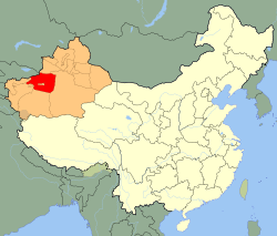 Aksu Prefecture (red) in Xinjiang (orange) | |
| Coordinates (Aksu City government): 41.18°N 80.29°E | |
| Country | People's Republic of China |
| Province | Xinjiang |
| County-level divisions | 8 |
| Seat | Aksu City |
| Area | |
| • Prefecture | 128,099 km2 (49,459 sq mi) |
| • Urban | 14,450 km2 (5,580 sq mi) |
| • Metro | 14,450 km2 (5,580 sq mi) |
| Elevation | 1,519 m (4,984 ft) |
| Population (2015 Census) | |
| • Prefecture | 2,530,506 |
| • Density | 20/km2 (51/sq mi) |
| • Urban | 535,657 |
| • Urban density | 37/km2 (96/sq mi) |
| • Metro | 535,657 |
| Time zone | UTC+8 (China Standard) |
| Postal code | 843000 |
| Area code(s) | 997 |
| ISO 3166 code | CN-XJ-29 |
| License Plate | 新N |
| Website | Aksu Prefecture Government |
| Aksu Prefecture | |||||||||||
|---|---|---|---|---|---|---|---|---|---|---|---|
| Uyghur name | |||||||||||
| Uyghur | ئاقسۇ ۋىلايىتى | ||||||||||
| |||||||||||
| Chinese name | |||||||||||
| Traditional Chinese | 阿克蘇地區 | ||||||||||
| Simplified Chinese | 阿克苏地区 | ||||||||||
| |||||||||||
Etymology
The name Aksu is Turkic for 'white water'.[4] The name is similar to that of the nearby Zhetysu region which means "seven rivers".[5] The name of Aksu Prefecutre's Onsu County (Wensu) means "ten water" in Uyghur and other Turkic languages- all three names consist of a descriptor followed by 'su' (river; water).[6]
History
In 717 AD, the Arabs, guided by their Turgesh allies, besieged Buat-ɦuɑn (Aksu) and Dai-dʑiᴇk-dʑiᴇŋ (Uqturpan) in the Battle of Aksu.
During the COVID-19 pandemic in mainland China, 214 Uyghur workers were sent to Jiujiang, Jiangxi.[7]
Geography
The prefecture occupies the northwestern part of the Tarim Basin and the southern slopes of the Tian Shan. The southern part of the prefecture is within the Taklamakan desert. Agriculture is only possible in the areas irrigated by the Tarim River and its glacier-fed tributaries, the Aksu River and the Muzart River. Aksu Prefecture surrounds Aral, Xinjiang.
Administrative divisions
Aksu Prefecture is divided into 2 county-level cities and 8 counties:
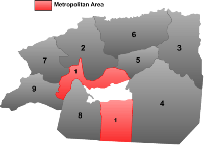 | |||||||||
| # | Name | Uyghur (UEY) | Uyghur Latin (ULY) | Chinese (S) | Hanyu Pinyin | Population (2010 Census) | Area (km²) | Density (/km²) | |
|---|---|---|---|---|---|---|---|---|---|
| 1 | Aksu | ئاقسۇ شەھىرى | Aqsu Shehiri | 阿克苏市 | Ākèsū Shì | 535,657 | 13,647 | 39.25 | |
| 2 | Onsu County (Wenu[1]) | ئونسۇ ناھىيىسى | Onsu Nahiyisi | 温宿县 | Wēnsù Xiàn | 233,933 | 14,376 | 16.27 | |
| 3 | Kuqa (Kuchar, Kucha, Kuche) | كۇچار ناھىيىسى | Kuchar Nahiyisi | 库车县 | Kùchē Xiàn | 462,588 | 14,529 | 31.83 | |
| 4 | Xayar County | شايار ناھىيىسى | Shayar Nahiyisi | 沙雅县 | Shāyǎ Xiàn | 257,502 | 31,887 | 8.07 | |
| 5 | Xinhe County[1] (Toksu) | توقسۇ ناھىيىسى | Toqsu Nahiyisi | 新和县 | Xīnhé Xiàn | 172,064 | 5,831 | 29.50 | |
| 6 | Baicheng County[1] | باي ناھىيىس | Bay Nahiyisi | 拜城县 | Bàichéng Xiàn | 229,252 | 15,917 | 14.40 | |
| 7 | Uqturpan County (Wushi[1]) | ئۇچتۇرپان ناھىيىسى | Uchturpan Nahiyisi | 乌什县 | Wūshí Xiàn | 197,990 | 9,065 | 21.84 | |
| 8 | Awat County | ئاۋات ناھىيىسى | Avat Nahiyisi | 阿瓦提县 | Āwǎtí Xiàn | 237,562 | 12,592 | 18.86 | |
| 9 | Kalpin County (Kelpin) | كەلپىن ناھىيىسى | Kelpin Nahiyisi | 柯坪县 | Kēpíng Xiàn | 44,261 | 8,915 | 4.96 | |
Demographics
Of its 2.53 million inhabitants, 80.1% are Uyghur, 18.42% are Han, with the remainder belonging to other ethnicities.
As of 2015, 2,030,600 of the 2,530,506 residents of the county were Uyghur, 465,983 were Han Chinese and 33,923 were from other ethnic groups.[8]
As of 1999, 74.99% of the population of Aksu (Aqsu, Akesu) Prefecture was Uyghur and 23.74% of the population was Han Chinese.[9]
References
- The official spelling according to 中国地名录. Beijing: SinoMaps Press (中国地图出版社). 1997. ISBN 7-5031-1718-4.
- "Archived copy". Archived from the original on 2013-05-12. Retrieved 2013-05-21.CS1 maint: archived copy as title (link)
- Liu Xin (29 April 2019). "Border guards in China's Xinjiang devote their lives to keeping country secure". Global Times. Archived from the original on 6 March 2020. Retrieved 8 May 2020.
- 阿克苏市概况. ئاقسۇ阿克苏市人民政府 (in Chinese). Retrieved 18 May 2020.
阿克苏市,维吾尔语意为“白水城”,
- Madeleine Reeves, ed. (2012). "Movement, Power and Place in Central Asia and Beyond: Contested Trajectories". p. 134. ISBN 978-0-415-50353-2.
Jeti Suu{...}Seven Waters
- "Archived copy" 温宿县人民政府 领导致词 (in Chinese). Wensu (Onsu) County People's Government. 2019-03-22. Archived from the original on 7 April 2020. Retrieved 30 November 2019.
温宿,维吾尔语意为“十股水”
CS1 maint: archived copy as title (link) - Mamatjan Juma,Alim Seytoff, Joshua Lipes (27 February 2020). "Xinjiang Authorities Sending Uyghurs to Work in China's Factories, Despite Coronavirus Risks". Radio Free Asia. Translated by Mamatjan Juma, Alim Seytoff. Archived from the original on 28 February 2020. Retrieved 2 February 2020.
Recent reports by the official Xinjiang Daily and Chinanews.com said that from Feb. 22-23, “400 youths were transferred to the provinces of Hunan, Zhejiang, and Jiangxi.” Of those, 114 from Awat (in Chinese, Awati) county, in the XUAR’s Aksu (Akesu) prefecture, were sent to Jiangxi’s Jiujiang city on Feb. 23, 100 from Aksu city were sent to Jiujiang on Feb. 22, and 171 from Hotan (Hetian) prefecture were sent to Changsha city in Hunan province, the reports said, without providing a date for the last transfer.
CS1 maint: multiple names: authors list (link) - 3-7 各地、州、市、县(市)分民族人口数 (in Chinese). شىنجاڭ ئۇيغۇر ئاپتونوم رايونى 新疆维吾尔自治区统计局 Statistic Bureau of Xinjiang Uygur Autonomous Region. 15 March 2017. Archived from the original on 11 October 2017. Retrieved 3 September 2017.
- Morris Rossabi, ed. (2004). Governing China’s Multiethnic Frontiers (PDF). University of Washington Press. p. 179. ISBN 0-295-98390-6. Archived (PDF) from the original on 2020-01-07. Retrieved 2020-05-09.
| Wikimedia Commons has media related to Aksu Prefecture. |
| Authority control |
|
|---|