Hotan Prefecture
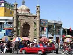
Hotan Prefecture[8][9] (also known as Godana, Godaniya, Gosthana, Khotan, Hetian, Hotien)[10] is located in the Dzungaria region in the southwestern part of the Xinjiang Uygur Autonomous Region, China, bordering the Tibet Autonomous Region to the south and Union Territory of Ladakh to the west. The vast majority of the Aksai Chin region which is disputed between China and India is administered as part of Hotan Prefecture. The seat of Hotan Prefecture is Hotan and its largest county by population is Karakax County. The vast majority of the residents of the prefecture are Muslim Uyghurs and live around oases situated between the desolate Taklamakan Desert and Kunlun Mountains.
Hotan Prefecture خوتەن ۋىلايىتى · 和田地区 Godana, Godaniya, Gosthana, Khotan, Hetian, Hotien | |
|---|---|
Prefecture | |
 Hotan City | |
 Hotan prefecture (red) (including Kunyu) in Xinjiang (orange) | |
| Country | People's Republic of China |
| Region | Xinjiang |
| Seat | Hotan[1] |
| Government | |
| • CPC Secretary (地委书记) | Yang Fasen (杨发森[2]) |
| Area | |
| • Total | 247,800 km2 (95,700 sq mi) |
| Population | |
| • Total | 2,014,362 |
| • Density | 8.1/km2 (21/sq mi) |
| Ethnic groups | |
| • Major ethnic groups | Uyghur, Han Chinese[4][5][6][7]:178 |
| Time zone | UTC+8 (China Standard) |
| ISO 3166 code | CN-XJ-32 |
| Website | xjht |
| Hotan Prefecture | |||||||||||
|---|---|---|---|---|---|---|---|---|---|---|---|
| Uyghur name | |||||||||||
| Uyghur | خوتەن ۋىلايىتى | ||||||||||
| |||||||||||
| Chinese name | |||||||||||
| Simplified Chinese | 和田地区 | ||||||||||
| Traditional Chinese | 和田地區 | ||||||||||
| |||||||||||
The region was the center of the ancient Iranian Saka Buddhist Kingdom of Khotan. Later, the region was part of the Kara-Khanid Khanate, followed by the Qara Khitai, Chagatai Khanate, Moghulistan and the Dzungar Khanate, which was conquered by the Qing dynasty of China. Hotan became part of Xinjiang under Qing rule.[11] In the 1930s, the Khotan Emirate declared independence from China. The PLA entered Hotan in 1949.
The prefecture is known for its jade, silk and carpets.
Etymology
The prefecture is named for its seat, Hotan (Khotan, Hetian, Hotien).
The area of Hotan is historically known as Godana or Godaniya, a Sanskrit name meaning "Land of the cows". In Chinese, the same name is written as Yu-t'ien, pronounced as Gu-dana. It is referred to as Gosthana by local Tibetans, which also means the same in Sanskrit.[10]
History
The Hotan Prefecture region played a major part in the Dungan Revolt (1862–1877).[11]
Tunganistan was an independent administered region in the southern part of Xinjiang from 1934 to 1937. The territory included the oases of the southern Tarim Basin; the centre of the region was Khotan.
On December 22, 1949, PLA forces reached Hotan. In 1950, the area was redesignated as Hotan District (和闐專區).[12]
In 1959, the Chinese character name of Hotan was changed from '和阗' to the homophonous '和田'.[1][12]
In 1962, events of the Sino-Indian War occurred in parts of Aksai Chin administered as part of Hotan Prefecture.
In 1971, Hotan was changed from a district (专区) to a prefecture (地区).[12]
According to a reporter for the Wen Wei Po in Ürümqi, between January and August 2005, authorities had disbanded six "illegal underground" religious schools in Hotan Prefecture and confiscated more than one hundred unauthorized religious books and periodicals as well as 972 audio and video tapes.[13][14]
In 2016, Kunyu was established within the boundaries of Hotan Prefecture.
In 2020 during the COVID-19 pandemic in mainland China, 171 Uyghur workers from Hotan Prefrcture were sent to Changsha, Hunan.[15]
Geography
The vast majority of the residents live around oases situated between the desolate Taklamakan Desert and Kunlun Mountains. To the north, the prefecture borders Aksu Prefecture, to the east Bayingolin Mongol Autonomous Prefecture, to the west Kashgar Prefecture, and to the south, Tibet and the areas disputed between China, India and Pakistan. Aksai Chin includes the southernmost point administered as part of Xinjiang. Most of the prefecture has a cold desert climate.
Administrative divisions
The Hotan Prefecture is divided into one county-level city and seven counties and surrounds Kunyu:[16][2]
 (Outdated map: Kunyu was established within the boundaries of Hotan Prefecture in 2016) | |||||||||
| # | Name | Uyghur (UEY) | Uyghur Latin (ULY) | Chinese (S) | Hanyu Pinyin | Population (2010) | Area (km²) | Density (/km²) | |
|---|---|---|---|---|---|---|---|---|---|
| 1 | Hotan[8] (Hetian) | خوتەن شەھىرى | Hoten Shehiri | 和田市 | Hétián Shì | 322,300 | 466 | 691.63 | |
| 2 | Hotan County[8] (Hetian) | خوتەن ناھىيىسى | Hoten Nahiyisi | 和田县 | Hétián Xiàn | 269,941 | 41,403[lower-alpha 2] | 6.51 | |
| 3 | Moyu County[8] (Karakax) | قاراقاش ناھىيىسى | Qaraqash Nahiyisi | 墨玉县 | Mòyù Xiàn | 500,114 | 25,789 | 19.39 | |
| 4 | Pishan County[8] (Guma) | گۇما ناھىيىسى | Guma Nahiyisi | 皮山县 | Píshān Xiàn | 258,210 | 39,742 | 6.49 | |
| 5 | Lop County (Luopu) | لوپ ناھىيىسى | Lop Nahiyisi | 洛浦县 | Luòpǔ Xiàn | 232,916 | 14,314 | 16.27 | |
| 6 | Qira County (Chira, Cele) | چىرا ناھىيىسى | Chira Nahiyisi | 策勒县 | Cèlè Xiàn | 147,050 | 31,688 | 4.64 | |
| 7 | Yutian County[8] (Keriya) | كېرىيە ناھىيىسى | Kériye Nahiyisi | 于田县 | Yútián Xiàn | 249,899 | 39,095 | 6.39 | |
| 8 | Niya County (Minfeng[8]) | نىيە ناھىيىسى | Niye Nahiyisi | 民丰县 | Mínfēng Xiàn | 33,932 | 56,760 | 0.59 | |

Demographics
| Historical population | ||
|---|---|---|
| Year | Pop. | ±% p.a. |
| 2000 | 1,681,310 | — |
| 2010 | 2,014,362 | +1.82% |
| [4] | ||
According to the analysis of Adrian Zenz, the population growth of Hotan declined significantly between 2015 and 2018.[17]
As of the 2000s, the population of Hotan Prefecture was more than 95% Uyghur.[4][5][6][7]:178
In 2014, according to a local government employee in the township of Langru in Hotan County, "Islamic beliefs are very strong" in the prefecture.[6]
As of 2015, 2,248,113 of the 2,324,287 residents of the prefecture were Uyghur, 71,233 were Han Chinese and 4,941 were from other ethnic groups.[18]
Residents of Hotan Prefecture commonly speak Uyghur and often do not speak Mandarin Chinese.[9][7]:181[19][20][21]:241
As of 1999, 96.91% of the population of Hotan (Hetian) Prefecture was Uyghur and 3.08% of the population was Han Chinese.[22]
Notable persons
- Ismail Amat, former Chairman (Governor) of Xinjiang
- Islam Akhun, con-man
- Ablajan Awut Ayup, a pop singer, songwriter and dancer
- Kurban Tulum, promoted by the Communist Party of China as a symbol of unity with the Uyghurs
Historical maps
Historical English-language maps including modern-day Hotan Prefecture area:
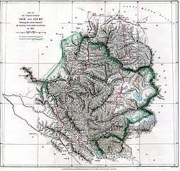 Map including ILCHÍ (1865)
 Map of the expeditions of Sven Hedin (1906-8) including the southern part of the modern Hotan Prefecture (RGS, early 20th century)
_p61_PLATE19._SINKIANG_(14597194848).jpg) Map including Hotan (labeled as Khotan) (1917)
Map including Hotan (labeled as Khotan) (1917)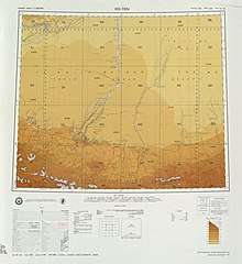 Map including most of northern Hotan Prefecture area (USATC, 1971)[lower-alpha 3]
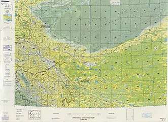 From the Operational Navigation Chart; map including Hotan Prefecture area (DMA, 1980)[lower-alpha 4]
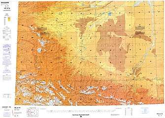 Map including Hotan Prefecture area (northwest) (DMA, 1984)[lower-alpha 5]
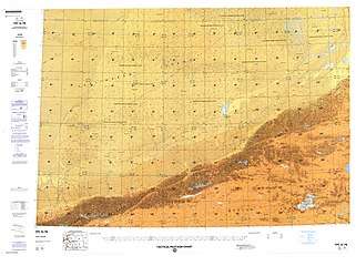 Map including Hotan Prefecture area (northeast) (DMA, 1990)[lower-alpha 6]
 Map including Hotan Prefecture area (southwest) with Aksai Chin (DMA, 1995)[lower-alpha 7]
Notes
- includes areas in Aksai Chin
- includes areas in Aksai Chin
- From map: "DELINEATION OF INTERNATIONAL BOUNDARIES MUST NOT BE CONSIDERED AUTHORITATIVE".
- From map: "The representation of international boundaries is not necessarily authoritative."
- From map: "The representation of international boundaries is not necessarily authoritative"
- From map: "The representation of boundaries is not necessarily authoritative."
- From map: "The representation of boundaries is not necessarily authoritative."
Footnotes
- 夏征农; 陈至立, eds. (September 2009). 辞海:第六版彩图本 [Cihai (Sixth Edition in Color)] (in Chinese). Shanghai: Shanghai Lexicographical Publishing House. p. 0866. ISBN 9787532628599.
和田 1市名。{...}和田地区行署驻此。{...}清设和阗直隶州,1913年改和阗县,1959年改和田县。
- 行政区划 [Administrative Divisions]. Hotan Prefecture People's Government. 19 January 2018. Retrieved 23 January 2020.
和田地区辖和田市、和田县、皮山县、墨玉县、洛浦县、策勒县、于田县、民丰县7县1市,91个乡镇,13个街道办事处,98个社区,1384个行政村,还有生产建设兵团十四师及所属奴尔牧场、47团场、皮山农场及224团场。历任中共和田地委书记22位,专员14位,现任地委书记杨发森、行署专员艾则孜•木沙。
- 地貌气候 [Topography and Climate] (in Chinese). Hotan Prefecture People's Government. 15 November 2017. Retrieved 21 January 2020.
和田地区位于新疆维吾尔自治区最南端。{...}总面积24.78万平方公里。
- 和田地区历史沿革 [Hotan Prefecture Historical Evolution]. XZQH.org (in Chinese). 1 December 2014. Retrieved 21 January 2020.
2000年第五次人口普查,和田地区常住总人口1681310人。{...}2000年末,和田地区常住总人口168.15万,其中非农业人口23.67万人,占总人口的14.08%;维吾尔族162.56万人,占总人口的96.67%。{...}2003年,和田地区总面积248945.29平方千米,{...}2010年第六次人口普查,和田地区常住总人口2014362人,
- "Archived copy" 1997年和田地区行政区划. XZQH.org (in Chinese). 17 February 2011. Archived from the original on 30 October 2019. Retrieved 24 March 2020.
维吾尔族占96.9%,汉族占2.9%。
CS1 maint: archived copy as title (link) - Richard Finney, Jelil Kashgari and Erkin Tarim (17 December 2014). "Uyghurs Face Seizure of Land, Personal Property Under Tough New Rules". Translated by Eset Sulaiman. Radio Free Asia. Archived from the original on 22 December 2019. Retrieved 18 January 2020.
Government employees at the local level frequently regret the difficulties caused by these requirements, an employee at Langru’s Economy Management Office told RFA, adding, “But we have no choice, since these are the rules of our county.” Hotan prefecture, in which the county lies, “is a very special region in the [Xinjiang] Autonomous Region,” he said. “Most of our population here are Uyghurs, and their Islamic beliefs are very strong.”
- Colin Legerton, Jacob Rawson (2009). "Invisible China : A Journey Through Ethnic Borderlands". Chicago Review Press. pp. 178, 181. ISBN 978-1-55652-814-9 – via Internet Archive.
While much of Xinjiang is being overpopulated by Han migration from eastern China that has more than quadrupled the desert region's population in a mere half-century, Hotan has been protected from the influx by its remote location at the southern base of the Taklimakan. It remains more than 95 percent Uyghur.{...}Even after eight years in the city, he spoke only Uyghur. His few Han clients were forced to communicate in their limited Uyghur, he explained, as he himself had never learned Chinese. In Hotan, there was no need for it.
CS1 maint: uses authors parameter (link) - The official spelling is "Hotan" according to 中国地名录. Beijing: SinoMaps Press (中国地图出版社). 1997. p. 304. ISBN 7-5031-1718-4.
- Tao Yuan (陶源) (3 January 2020). "A closer look at Uygur students in boarding schools" (in English, Uyghur, and Chinese). China Global Television Network. Event occurs at 0:42, 1:58, 2:05, 3:35. Retrieved 24 January 2020 – via YouTube.
Student, Moyu County Beijing Middle School
墨玉縣北京高級中學學生{...}
胡木旦村{...}
No other family member speaks Mandarin Chinese,
凱麥爾妮薩的家人都不會講國家通用語言{...}
Tao Yuan, CGTN, Hotan, Xinjiang.
CGTN 陶源 新疆和田 - Wang, Bangwei; Sen, Tansen (2011). India and China: Interactions through Buddhism and Diplomacy: A Collection of Essays by Professor Prabodh Chandra Bagchi. Anthem Press. p. 186.
- "Hotan". Encyclopædia Britannica. Archived from the original on 25 August 2019. Retrieved 24 January 2020.
- 历史沿革 (in Chinese). Hotan Prefecture People's Government. 19 January 2019. Retrieved 22 January 2020.
1949年12月22日中国人民解放军十五团抵达和阗 ,和阗解放。1950年改称和阗专区,1959年改和阗为和田,1971年改专区为地区,1979年建立和田行政公署。
- [2005-08-31] 新疆破獲東突分裂組織. Wen Wei Po (in Chinese). 31 August 2005. Archived from the original on 7 November 2005 – via Internet Archive.
據悉,今年以來,該地區已查獲地下非法教經點6個,查收非法宗教書刊100餘本、音像製品972盒和帶有違法的各類物品1,874件。
- "Uighur Separatists Arrested in Xinjiang's Hetian Prefecture". Congressional-Executive Commission on China. 7 September 2005. Archived from the original on 14 July 2019. Retrieved 23 January 2020.
The article also reports that since January, Hetian authorities have disbanded six "illegal underground" religious schools and confiscated unauthorized religious books, periodicals, and audio and video tapes.
- Mamatjan Juma,Alim Seytoff, Joshua Lipes (27 February 2020). "Xinjiang Authorities Sending Uyghurs to Work in China's Factories, Despite Coronavirus Risks". Radio Free Asia. Translated by Mamatjan Juma, Alim Seytoff. Archived from the original on 28 February 2020. Retrieved 2 February 2020.
Recent reports by the official Xinjiang Daily and Chinanews.com said that from Feb. 22-23, “400 youths were transferred to the provinces of Hunan, Zhejiang, and Jiangxi.” Of those, 114 from Awat (in Chinese, Awati) county, in the XUAR’s Aksu (Akesu) prefecture, were sent to Jiangxi’s Jiujiang city on Feb. 23, 100 from Aksu city were sent to Jiujiang on Feb. 22, and 171 from Hotan (Hetian) prefecture were sent to Changsha city in Hunan province, the reports said, without providing a date for the last transfer.
CS1 maint: multiple names: authors list (link) - 2018年统计用区划代码和城乡划分代码:和田地区 [2018 Statistical Area Numbers and Rural-Urban Area Numbers: Hotan Prefecture] (in Chinese). National Bureau of Statistics of the People's Republic of China. 2018. Retrieved 23 January 2020.
统计用区划代码 名称 653201000000 和田市 653221000000 和田县 653222000000 墨玉县 653223000000 皮山县 653224000000 洛浦县 653225000000 策勒县 653226000000 于田县 653227000000 民丰县
- Adrian Zenz (24 November 2019). "China Didn't Want Us to Know. Now Its Own Files Are Doing the Talking". New York Times. Archived from the original on 21 December 2019. Retrieved 24 December 2019.
Official statistics show that the combined net population growth rates of Hotan and Kashgar, two of the largest Uighur regions, dropped by about 84 percent between 2015 and 2018.
- 3-7 各地、州、市、县(市)分民族人口数 (in Chinese). شىنجاڭ ئۇيغۇر ئاپتونوم رايونى 新疆维吾尔自治区统计局 Statistic Bureau of Xinjiang Uygur Autonomous Region. Archived from the original on 2017-10-11. Retrieved 2017-09-03.
- Peter Neville-Hadley (1997). China the Silk Routes. Cadogan Guides. Globe Pequot Press. p. 304. ISBN 1-86011-052-5 – via Internet Archive.
Travelling east from Khotan{...}Many Uighurs speak no Chinese at all, and most hotels are even less likely to have English speakers than those elsewhere in China.
- David Eimer (2014). The Emperor Far Away: Travels at the Edge of China. Bloomsbury USA. p. 75. ISBN 978-1-62040-363-1 – via Internet Archive.
Far fewer people understood Mandarin in Hotan than anywhere else I'd been in Xinjiang. It made getting around difficult, as not only did the taxi drivers fail to understand what I was saying, but they couldn't read an address either. Most ignored or didn't know the Chinese names given to the streets anyway.
- 王炜, ed. (2004). 新疆 [Xinjiang] (in Chinese). Beijing: Encyclopedia of China Publishing House. pp. 235, 241. ISBN 7-5000-6883-2 – via Internet Archive.
和田地区{...}安全 因为与当地人语言交流可能有障碍,注意礼貌和当地习俗是非常必要,以免发生不必要的争执。
- Morris Rossabi, ed. (2004). Governing China’s Multiethnic Frontiers (PDF). University of Washington Press. p. 180. ISBN 0-295-98390-6. Archived (PDF) from the original on 2020-01-07. Retrieved 2020-05-04.
External links
| Wikimedia Commons has media related to Hotan Prefecture. |