Zalantun
Zalantun (Manchu J̌alan Ai"l or Jalan Tun) or Zhalantun (simplified Chinese: 扎兰屯; traditional Chinese: 扎蘭屯; pinyin: Zhālántún; Mongolian: ᠵᠠᠯᠠᠨ ᠠᠢ᠌ᠯ ᠬᠣᠲᠠ Жалан-Айл хот), is a city with an estimated population of 132,408 and administrative division of Hulunbuir Prefecture-level city, Inner Mongolia, China. It is in the northeastern part of Inner Mongolia, in the southeastern foothills of the Greater Khingan mountains, bordering Heilongjiang province to the east. It is an area which has a number of forests and streams, as well as the Yalu River, not to be confused with the Yalu River on the Sino-Korean border. It is known for its hunting and fishing.
Zalantun 扎兰屯市 • ᠵᠠᠯᠠᠨᠠᠢ᠌ᠯᠬᠣᠲᠠ Cha-lan-t'un | |
|---|---|
 | |
| Nickname(s): | |
 Zalantun in Hulunbuir | |
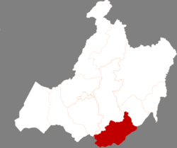
 Zalantun Location in Inner Mongolia | |
| Coordinates: 48°01′37″N 122°42′29″E | |
| Country | People's Republic of China |
| Autonomous region | Inner Mongolia |
| Prefecture-level city | Hulunbuir |
| Area | |
| • County-level city | 16,800.0 km2 (6,486.5 sq mi) |
| • Urban | 385.00 km2 (148.65 sq mi) |
| Population (2017) | |
| • County-level city | 448,000 |
| • Density | 27/km2 (69/sq mi) |
| • Urban | 134,400 |
| Time zone | UTC+8 (China Standard) |
| Postal code | 162650 |
| Area code(s) | 0470 |
| Website | www |
History

Zalantun was formerly known as Butha (布特哈; Bùtèhā), and the city was made into an administrative centre in the Kangxi era. In 1929, Buteha was renamed as Yalu county (雅鲁县; Yǎlǔ Xiàn) because the Yalu River runs through it, but in 1933 it became the Zalantun Banner (扎兰屯旗; Zhālántún Qí). In 1983, Zalantun ceased to be a banner and became a part of Hulunbuir, remaining so today.
Climate
Zalantun has a monsoon-influenced humid continental climate (Köppen Dwb), with long, bitterly cold winters, warm summers, and short transitional seasons. The monthly mean temperature ranges from −16.5 °C (2.3 °F) in January to 21.7 °C (71.1 °F) in July, while the annual mean is 3.65 °C (38.6 °F). Typifying the influence of the East Asian Monsoon, on average, a majority of the annual 501 millimetres (19.7 in) of precipitation falls in July and August alone.
| Climate data for Zhalantun (1981–2010 normals, extremes 1971–2010) | |||||||||||||
|---|---|---|---|---|---|---|---|---|---|---|---|---|---|
| Month | Jan | Feb | Mar | Apr | May | Jun | Jul | Aug | Sep | Oct | Nov | Dec | Year |
| Record high °C (°F) | 4.3 (39.7) |
11.7 (53.1) |
22.1 (71.8) |
30.7 (87.3) |
38.0 (100.4) |
40.2 (104.4) |
40.1 (104.2) |
35.2 (95.4) |
35.5 (95.9) |
29.7 (85.5) |
17.0 (62.6) |
5.9 (42.6) |
40.2 (104.4) |
| Average high °C (°F) | −11.0 (12.2) |
−5.5 (22.1) |
2.3 (36.1) |
12.7 (54.9) |
20.9 (69.6) |
26.0 (78.8) |
27.1 (80.8) |
25.7 (78.3) |
20.0 (68.0) |
11.0 (51.8) |
−1.3 (29.7) |
−9.7 (14.5) |
9.9 (49.7) |
| Daily mean °C (°F) | −16.5 (2.3) |
−12.0 (10.4) |
−4.1 (24.6) |
6.0 (42.8) |
14.0 (57.2) |
19.6 (67.3) |
21.7 (71.1) |
19.8 (67.6) |
13.1 (55.6) |
4.3 (39.7) |
−7.2 (19.0) |
−14.9 (5.2) |
3.7 (38.6) |
| Average low °C (°F) | −20.8 (−5.4) |
−17.0 (1.4) |
−9.7 (14.5) |
−0.3 (31.5) |
7.1 (44.8) |
13.7 (56.7) |
17.1 (62.8) |
15.1 (59.2) |
7.6 (45.7) |
−1.1 (30.0) |
−11.8 (10.8) |
−19.1 (−2.4) |
−1.6 (29.1) |
| Record low °C (°F) | −34.7 (−30.5) |
−34.5 (−30.1) |
−26.7 (−16.1) |
−14.2 (6.4) |
−6.3 (20.7) |
2.8 (37.0) |
8.0 (46.4) |
1.6 (34.9) |
−5.7 (21.7) |
−15.9 (3.4) |
−25.3 (−13.5) |
−34.5 (−30.1) |
−34.7 (−30.5) |
| Average precipitation mm (inches) | 1.6 (0.06) |
2.0 (0.08) |
5.0 (0.20) |
21.9 (0.86) |
36.2 (1.43) |
89.0 (3.50) |
160.4 (6.31) |
119.6 (4.71) |
40.1 (1.58) |
16.5 (0.65) |
4.3 (0.17) |
4.7 (0.19) |
501.3 (19.74) |
| Average precipitation days (≥ 0.1 mm) | 2.2 | 2.4 | 3.3 | 4.9 | 7.9 | 13.8 | 15.7 | 13.2 | 9.4 | 4.5 | 3.1 | 3.9 | 84.3 |
| Average relative humidity (%) | 58 | 51 | 43 | 41 | 42 | 60 | 72 | 72 | 61 | 52 | 55 | 61 | 56 |
| Source: China Meteorological Administration,[2] Weather China (precipitation days 1971–2000)[3] | |||||||||||||
Economy
Zalantun's economy is based primarily on tourism and agriculture, livestock and forestry. The Harbin-Manzhouli Railway traverses the district. It is rich in food grains, particularly wheat, soy and corn, as well as cattle, sheep, horse and other livestock. It has an industrial base in paper production, candy production, and wool. It has an annual average temperature of 2 °C and an average annual precipitation of 480mm. The northwest portion of the district consists of natural forests in the Greater Khingan mountains.
Transport
Zhalantun Chengjisihan Airport was opened in December 2016.[4]
References
- Ministry of Housing and Urban-Rural Development, ed. (2019). China Urban Construction Statistical Yearbook 2017. Beijing: China Statistics Press. p. 46. Retrieved 11 January 2020.
- 中国气象数据网 - WeatherBk Data (in Chinese). China Meteorological Administration. Retrieved 2020-04-15.
- http://www.weather.com.cn/cityintro/101081012.shtml?
- 内蒙古扎兰屯成吉思汗机场投入使用. Civil Aviation Administration of China (in Chinese). 28 December 2016.