Hotan
Hotan[note 1] (also known as Godana, Godaniya, Gosthana, Khotan, Hetian, Hotien)[4] is a major oasis town in southwestern Xinjiang, an autonomous region in Western China. The city proper of Hotan broke off from the larger Hotan County to become an administrative area in its own right in August 1984. It is the seat of Hotan Prefecture.
Hotan خوتەن شەھىرى 和田市 Khotan, Godana, Gosthana | |
|---|---|
 | |
 Hotan Location in Xinjiang | |
| Coordinates: 37°06′N 80°01′E | |
| Country | People's Republic of China |
| Autonomous region | Xinjiang |
| Prefecture | Hotan |
| Seat | Nurbag Subdistrict (奴尔巴格街道) |
| Area | |
| • Total | 465.84 km2 (179.86 sq mi) |
| Elevation | 1,382 m (4,534 ft) |
| Population (2010)[1] | |
| • Total | 322,330 |
| • Density | 690/km2 (1,800/sq mi) |
| Ethnic groups | |
| • Major ethnic groups | Uyghur[2] |
| Time zone | UTC+8 (China Standard) |
| Postal code | 839000 |
| Area code(s) | 0903 |
| GDP (2012)[3] | CNY 4.071 billion USD $665.15 million |
| GDP per capita | CNY 12,630 USD $2,062 |
| GDP Growth | |
| Local languages | Uyghur, Mandarin Chinese |
| License plate prefix | 新R |
| Website | Hotan Government Website (in Chinese) |
| Hotan | |||||||||||
|---|---|---|---|---|---|---|---|---|---|---|---|
| Uyghur name | |||||||||||
| Uyghur | خوتەن | ||||||||||
| |||||||||||
| Chinese name | |||||||||||
| Chinese | 和田 | ||||||||||
| |||||||||||
| Alternative Chinese name | |||||||||||
| Simplified Chinese | 和阗 | ||||||||||
| Traditional Chinese | 和闐 | ||||||||||
| |||||||||||
| Second alternative Chinese name | |||||||||||
| Simplified Chinese | 于窴 | ||||||||||
| Traditional Chinese | 於窴 | ||||||||||
| |||||||||||
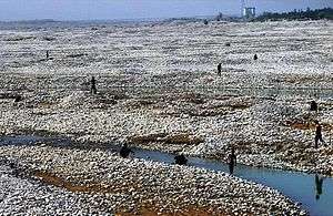
With a population of 322,300 (2010 census), Hotan is situated in the Tarim Basin some 1,500 kilometres (930 mi) southwest of the regional capital, Ürümqi. It lies just north of the Kunlun Mountains, which are crossed by the Sanju, Hindutash and Ilchi passes. The town, located southeast of Yarkant County and populated almost exclusively by Uyghurs, is a minor agricultural center. An important station on the southern branch of the historic Silk Road, Hotan has always depended on two strong rivers—the Karakash River and the White Jade River to provide the water needed to survive on the southwestern edge of the vast Taklamakan Desert. The White Jade River still provides water and irrigation for the town and oasis.[5][6]
Etymology
The original name of Hotan is Godana and Godaniya, the name used in Sanskrit cosmological texts and also how the area is historically referred to as. Godana/Godaniya translate to "land of cows" in Sanskrit. In Chinese, the same name is written as Yu-t'ien, pronounced as Gu-dana. The pronunciation changed over the years to Kho-tan. In the 7th century, Xuanzang tried to reverse interpret it in Sanskrit as Kustana. However, the Tibetans continue to call it Gosthana, which also carries the meaning of "land of cows".[7][8]
History
The oasis of Hotan is strategically located at the junction of the southern (and most ancient) branch of the Silk Road joining China and the West with one of the main routes from ancient India and Tibet to Central Asia and distant China. It provided a convenient meeting place where not only goods, but technologies, philosophies, and religions were transmitted from one culture to another.
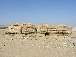
Tocharians lived in this region over 2000 years ago. Several of the Tarim mummies were found in the region. At Sampul, east of the city of Hotan, there is an extensive series of cemeteries scattered over an area about 1 kilometre (0.62 mi) wide and 23 km (14 mi) long. The excavated sites range from about 300 BCE to 100 CE. The excavated graves have produced a number of fabrics of felt, wool, silk and cotton and even a fine bit of tapestry, the Sampul tapestry, showing the face of Caucasoid man which was made of threads of 24 shades of colour. The tapestry had been cut up and fashioned into trousers worn by one of the deceased. An Anthropological study of 56 individuals showed a primarily Caucasoid population.[9][10] DNA testing on the mummies found in the Tarim basin showed that they were an admixture of Western Europeans and East Asian.[11]
There is a relative abundance of information on Hotan readily available for study. The main historical sources are to be found in the Chinese histories (particularly detailed during the Han[12] and early Tang dynasties) when China was interested in control of the Western Regions, the accounts of several Chinese pilgrim monks,[13] a few Buddhist histories of Hotan that have survived in Classical Tibetan and a large number of documents in the Iranian Saka language and other languages discovered, for the most part, early this century at various sites in the Tarim Basin and from the hidden library at the Mogao Caves near Dunhuang.
Buddhist Khotan
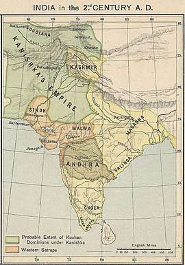
The ancient Kingdom of Khotan was one of the earliest Buddhist states in the world and a cultural bridge across which Buddhist culture and learning were transmitted from India to China.[14] Its capital was located to the west of the modern city of Hotan. The inhabitants of the Kingdom of Khotan, like those of early Kashgar and Yarkant, spoke Saka, one of the Eastern Iranian languages. Khotan's indigenous dynasty (all of whose royal names are Indian in origin) governed a fervently Buddhist city-state boasting some 400 temples in the late 9th/early 10th century—four times the number recorded by Xuanzang around 630. The kingdom was independent but was intermittently under Chinese control during the Han and Tang Dynasty.
After the Tang dynasty, Khotan formed an alliance with the rulers of Dunhuang. Khotan enjoyed close relations with the Buddhist centre at Dunhuang: the Khotanese royal family intermarried with Dunhuang élites, visited and patronised Dunhuang's Buddhist temple complex, and donated money to have their portraits painted on the walls of the Mogao grottos. Through the 10th century, Khotanese royal portraits were painted in association with an increasing number of deities in the caves.
In the 10th century, Khotan began a struggle with the Kara-Khanid Khanate, a Turkic state.[15] The Kara-Khanid ruler, Sultan Satuq Bughra Khan, had converted to Islam:
Satuq's son, Musa, began to put pressure on Khotan in the mid-10th century, and sometime before 1006 Yusuf Qadir Khan of Kashgar besieged and took the city. This conquest of Buddhist Khotan by the Muslim Turks—about which there are many colourful legends—marked another watershed in the Islamicisation and Turkicisation of the Tarim Basin, and an end to local autonomy of this southern Tarim city state.[16]
Some Khotanese Buddhist works were unearthed.[17][18][19]
The rulers of Khotan were aware of the menace they faced since they arranged for the Mogao grottoes to paint a growing number of divine figures along with themselves. Halfway in the 10th century Khotan came under attack by the Qarakhanid ruler Musa, and in what proved to be a pivotal moment in the Turkification and Islamification of the Tarim Basin, the Karakhanid leader Yusuf Qadir Khan conquered Khotan around 1006.[20]
Islamic Khotan
Yūsuf Qadr Khān was a brother or cousin of the Muslim ruler of Kashgar and Balasagun, Khotan lost its independence and between 1006 and 1165, became part of the Kara-Khanid Khanate. Later it fell to the Kara-Khitan Khanate, after which it was ruled by the Mongols.
When Marco Polo visited Khotan in the 13th century, he noted that the people were all Muslim. He wrote that:
Khotan was "a province eight days’ journey in extent, which is subject to the Great Khan. The inhabitants all worship Mahomet. It has cities and towns in plenty, of which the most splendid, and the capital of the province, bears the same name as that of the province…It is amply stocked with the means of life. Cotton grows here in plenty. It has vineyards, estates and orchards in plenty. The people live by trade and industry; they are not at all warlike".[21][22]
Qing dynasty
The town suffered severely during the Dungan Revolt (1862–77) against the Qing dynasty and again a few years later when Yaqub Beg of Kashgar made himself master of Kashgaria (Altishahr).[23][24]
Modern Hotan
Qing imperial authority collapsed in 1912. During the Republican era (1912–49), warlords and local ethnic self-determination movements wrestled over control of Xinjiang. Abdullah Bughra, Nur Ahmad Jan Bughra, and Muhammad Amin Bughra declared themselves Emirs of Khotan during the Kumul Rebellion. Tunganistan was an independent administered region in the southern part of Xinjiang from 1934 to 1937. The territory included the oases of the southern Tarim Basin; the centre of the region was Khotan. Beginning with the Islamic rebellion in 1937, Hotan and the rest of the province came under the control of warlord Sheng Shicai. Sheng was later ousted by the Kuomintang. Shortly after the Communists won the civil war in 1949, Hotan was incorporated into the People's Republic of China. In 1983/4, the urban area of Hotan was administratively split from the larger Hotan County, and from then on governed as a county-level city.[1][25]
On July 11, 2006, the townships of Jiya and Yurungqash (Yulongkashi) in Lop County and Tusalla (Tushala) in Hotan County were transferred to Hotan City.[1]
Following the July 2009 Ürümqi riots, ethnic tensions rose in Xinjiang and in Hotan in particular. As a result, the city has seen occasional bouts of violence. In June 2011, Hotan opened its first passenger-train service to Kashgar, which was established as a special economic zone following the riots. In July of the same year, a bomb and knife attack occurred on the city's central thoroughfare. In June 2011, authorities in Hotan Prefecture sentenced Uyghur Muslim Hebibullah Ibrahim to ten years imprisonment for selling "illegal religious materials".[26][27] In June 2012, Tianjin Airlines Flight 7554 was hijacked en route from Hotan to Ürümqi.
In a report from the Uyghur American Association, in June 2012, notice was said to be given that police planned to undertake a search of every residence in Gujanbagh (Gujiangbage), Hotan. Hotan is the last municipality in Xinjiang with a majority Ugyhur presence in the core of the city. The UAA viewed this as an attempt to systematically intimidate the Uyghur population in Hotan.[28]
Sultanim Cemetery was the central Uyghur graveyard and a sacred shrine in Hotan city. Between 2018 and 2019, the cemetery was demolished and made into a parking lot.[29]
Geography and climate
Hotan has a temperate zone, cold desert climate (Köppen BWk), with a mean annual total of only 36.5 millimetres (1.44 in) of precipitation falling on 17.3 days of the year. Due to its southerly location in Xinjiang just north of the Kunlun Mountains, during winter it is one of the warmest locations in the region, with average high temperatures remaining above freezing throughout the year. The monthly 24-hour average temperature ranges from −3.9 °C (25.0 °F) in January to 25.8 °C (78.4 °F) in July, and the annual mean is 13.03 °C (55.5 °F). The diurnal temperature variation is not large for a desert, averaging 11.8 °C (21.2 °F) annually. Although no month averages less than half of possible sunshine, the city only receives 2,587 hours of bright sunshine annually, which is on the low end for Xinjiang; monthly percent possible sunshine ranges from 50% in March to 75% in October.
| Climate data for Hotan (1981−2010 normals) | |||||||||||||
|---|---|---|---|---|---|---|---|---|---|---|---|---|---|
| Month | Jan | Feb | Mar | Apr | May | Jun | Jul | Aug | Sep | Oct | Nov | Dec | Year |
| Average high °C (°F) | 1.3 (34.3) |
6.9 (44.4) |
15.8 (60.4) |
23.5 (74.3) |
27.8 (82.0) |
31.1 (88.0) |
32.6 (90.7) |
31.7 (89.1) |
27.4 (81.3) |
20.6 (69.1) |
11.6 (52.9) |
3.1 (37.6) |
19.5 (67.0) |
| Daily mean °C (°F) | −3.9 (25.0) |
1.3 (34.3) |
9.6 (49.3) |
16.8 (62.2) |
21.1 (70.0) |
24.3 (75.7) |
25.8 (78.4) |
24.9 (76.8) |
20.4 (68.7) |
13.2 (55.8) |
5.1 (41.2) |
−2.2 (28.0) |
13.0 (55.5) |
| Average low °C (°F) | −8.2 (17.2) |
−3.4 (25.9) |
4.0 (39.2) |
10.7 (51.3) |
15.2 (59.4) |
18.5 (65.3) |
20.0 (68.0) |
19.3 (66.7) |
14.5 (58.1) |
7.0 (44.6) |
0.0 (32.0) |
−6.3 (20.7) |
7.6 (45.7) |
| Average precipitation mm (inches) | 1.9 (0.07) |
1.9 (0.07) |
2.5 (0.10) |
2.9 (0.11) |
7.2 (0.28) |
8.9 (0.35) |
7.2 (0.28) |
4.6 (0.18) |
3.6 (0.14) |
1.5 (0.06) |
0.5 (0.02) |
1.4 (0.06) |
44.1 (1.72) |
| Average precipitation days (≥ 0.1 mm) | 2.0 | 1.7 | 0.7 | 1.1 | 1.9 | 2.6 | 2.9 | 1.8 | 0.8 | 0.3 | 0.3 | 1.2 | 17.3 |
| Average relative humidity (%) | 54 | 44 | 32 | 29 | 34 | 38 | 43 | 44 | 44 | 41 | 43 | 54 | 42 |
| Mean monthly sunshine hours | 167.8 | 163.9 | 185.8 | 208.3 | 234.5 | 253.2 | 242.5 | 231.2 | 240.0 | 260.5 | 221.1 | 178.2 | 2,587 |
| Percent possible sunshine | 55 | 54 | 50 | 53 | 54 | 58 | 54 | 55 | 65 | 75 | 72 | 60 | 58 |
| Source: China Meteorological Administration (precipitation days and sunshine 1971–2000)[30][31] | |||||||||||||
Administrative divisions
The city includes four subdistricts, three towns, five townships and two other areas:[1][32][33]
Subdistricts:[34]
- Nurbag Subdistrict (Nu'erbage; 努尔巴格街道/奴尔巴格街道[35]), Gujanbagh Subdistrict (Gujiangbage; 古江巴格街道), Gulbagh Subdistrict (Gulebage; 古勒巴格街道), Na'erbage Subdistrict (纳尔巴格街道),
Towns:[36]
- Laskuy (Lasikui, Lasqi; لاسكۇي بازىرى / 拉斯奎镇), Yurungqash (Yulongkashi; يۇرۇڭقاش بازىرى / 玉龙喀什镇), Tusalla (Tushala; تۇساللا بازىرى, formerly تۇساللا يېزىسى / 吐沙拉镇, formerly 吐沙拉鄉)
Townships:
- Shorbagh Township (Xiao'erbage; شورباغ يېزىسى / 肖尔巴格乡), Ilchi Township (Yiliqi; ئىلچى يېزىسى / 伊里其乡), Gujanbagh Township (Gujiangbage; گۇجانباغ يېزىسى / 古江巴格乡), Jiya Township (جىيا يېزىسى / 吉亚乡), Aqchal Township (Akeqiale ئاقچال يېزىسى / 阿克恰勒乡)
Others:
- Beijing Industrial Park (北京工业园区), Hotan City Jinghe Logistics Park (和田市京和物流园区)
Demographics
Hotan is largely dominated by the Uyghurs. The urban population was recorded as 154,352 in 1998, 83% of which are Uyghurs, and 17% Han Chinese.[37]
In 1940, Owen Lattimore quoted the population of Khotan to be estimated as 26,000.[38]
In the 2000 census, the population was recorded as 186,123. In the 2010 census figure, the figure had risen to 322,300. The increase in population is partly due to boundary changes.[39]
As of 2015, 311,050 of the 348,289 residents of the county were Uyghur, 35,897 were Han Chinese and 1,342 were from other ethnic groups.[40]
As of 1999, 83.01% of the population of Hotan (Hetian) was Uyghur and 16.57% of the population was Han Chinese.[41]
Transportation
Air
Hotan Airport (IATA: HTN) serves the city. It serves regional flights to Ürümqi. Originally a military use airport, it was expanded significantly in 2002 to accommodate higher passenger volumes. It is located 12 km (7.5 mi) south of the city proper.
Road
Hotan is served by China National Highway 315, which runs along the southern Tarim Basin from Ruoqiang to Kashgar, and the Trans-Taklamakan Desert Highway, which run north to Luntai. An expressway is being built between Hotan and Karakax County (Moyu) as of 2014.
Rail
Hotan is connected to the rest of China's rail network via the Kashgar–Hotan Railway, which opened to freight traffic in December 2010, and passenger service in June 2011. The railway station was constructed by a company under the Xinjiang Production and Construction Corps, and is located in the town of Lasqi (拉斯奎) northwest of the city proper. Passenger train service on this line is limited, with only one train per day, local service 5828/5825, linking the city with Kashgar (8~ hours) and Ürümqi (~34 hours).
Buses
Regular bus services link Hotan with Kashgar. There is also an express bus to Aksu via the 430 km (270 mi) 'Hotan-Aksu Cross-Desert Highway' which was opened in 2007, travels alongside the intermittent Hotan River, and which takes about 5 or 6 hours. This same bus then goes on to Urumchi taking a total of about 21 hours from Hotan.[42]
Products
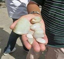
Nephrite jade
Chinese historical sources indicate that Hotan was the main source of the nephrite jade used in ancient China. For several hundred years, until they were defeated by the Xiongnu in 176 BCE, the trade of Khotanese jade into China was controlled by the nomadic Yuezhi. The Chinese still refer to the Yurungkash as the White Jade River, alluding to the white jade recovered from its alluvial deposits. The light coloured jade is called "Mutton fat" jade. Most of the jade is now gone, with only a few kilos of good quality jade found yearly. Some is still mined in the Kunlun Mountains to the south in the summer,[43] but it is generally of poorer quality than that found in the rivers.[44][45]
Fabrics and carpets
Khotanese textiles were mentioned by Xuanzang, who visited the oasis in 644 CE. In his Biography it is stated: "It produced carpets and fine felt, and the felt-makers also spun coarse and fine silk."[46]
Ancient Chinese-Khotanese relations were so close that the oasis emerged as one of the earliest centres of silk manufacture outside China. There are good reasons to believe that the silk-producing industry flourished in Hotan as early as the 5th century.[47] According to one story, a Chinese princess given in marriage to a Khotan prince brought to the oasis the secret of silk-manufacture, "hiding silkworms in her hair as part of her dowry", probably in the first half of the 1st century CE.[48][49] It was from Khotan that the eggs of silkworms were smuggled to Iran, reaching Justinian I's Constantinople in 551.[50] Silk production is still a major industry employing more than a thousand workers and producing some 150 million metres of silk annually. Silk weaving by Uyghur women is a thriving cottage industry, some of it produced using traditional methods.[43] Hotan Silk Factory is one of the notable silk producers in Hotan.
Atlas is the fabric used for traditional Uyghur clothing worn by Uyghur women. It is soft, light and graceful tie-dyed silk fabric. It comes various colours, the brighter and rich colours are for small children to young ladies. The gray and dark colours are for elderly women.
The oldest piece of kilim which we have any knowledge was obtained by the archaeological explorer Aurel Stein; a fragment from an ancient settlement near Hotan, which was buried by sand drifts about the fourth century CE. The weave is almost identical with that of modern kilims.
Hotanese pile carpets are still highly prized and form an important export.[51][52]
Notable persons
- Islam Akhun, con-man
Gallery
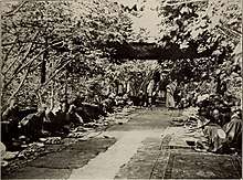
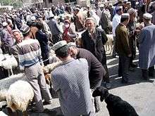
 Market in Hotan
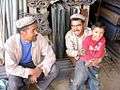 Uyghur people at Sunday market
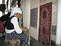 Carpet weaving in Hotan
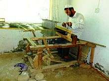
 Silk weaving in Hotan
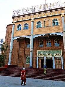 Entrance to the Hotan Cultural Museum
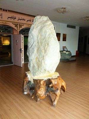 Local jade displayed in the Hotan Cultural Museum lobby.
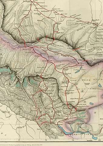
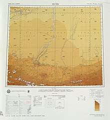
 Map including Hotan (Ho-t'ien, Khotan) (DMA, 1983)
See also
Notes
- The official Latin transliteration (and therefore, English spelling) of the city's name is "Hotan" according to Register of Chinese Geographic Places (中国地名录, published in Beijing, SinoMaps Press 中国地图出版社 1997; ISBN 7-5031-1718-4; p. 312.); The pinyin romanization Hetian has also been used on some maps and airports; the city's former name was written with a different character for "Tian" (simplified Chinese: 阗; traditional Chinese: 闐; pinyin: Tián); the city is also sometimes spelled Khotan, such as in this example. The city has also been called Yutian in Chinese and was known to 19th-century European explorers as Ilchi.
- From map: "DELINEATION OF INTERNATIONAL BOUNDARIES MUST NOT BE CONSIDERED AUTHORITATIVE".
References
Citations
- 和田市历史沿革 [Hotan City Historical Development] (in Chinese). XZQH.org. 2 December 2014. Retrieved 20 December 2019.
1984年和田县析置和田市。{...}2003年,和田市总面积155.04平方千米,{...}2006年7月11日,洛浦县吉亚乡、玉龙喀什镇与和田县吐沙拉乡正式划归和田市管辖。两乡一镇划归和田市管辖后,和田市管辖区域变为五乡、两镇、一个管理区、一个工业园区和四个街道办事处。和田市的行政区域面积由155.04平方千米扩大至465.84平方千米,{...}2010年第六次人口普查,和田市常住总人口322300人,其中:奴尔巴格街道24134人,古江巴格街道34567人,古勒巴格街道27919人,纳尔巴格街道37338人,拉斯奎镇25231人,玉龙喀什镇22614人,肖尔巴格乡39331人,伊里其乡22646人,古江巴格乡13680人,吐沙拉乡48468人,吉亚乡22071人,阿合恰管理区4301人。
- 1997年和田市行政区划 [1997 Hotan City Administrative Divisions]. XZQH.org. 6 January 2011. Retrieved 3 April 2020.
面积189平方千米,人口14.8万,有维吾尔、汉、回、哈萨克、蒙古、锡伯、柯尔克孜等13个民族,其中维吾尔族占85%,辖4个街道1镇3乡。
- "和田市概况". Hotan Government Statistics. June 17, 2013. Archived from the original on November 29, 2014.
- Wang, Bangwei; Sen, Tansen (2011). India and China: Interactions through Buddhism and Diplomacy: A Collection of Essays by Professor Prabodh Chandra Bagchi. Anthem Press. p. 186.
- Marc Aurel Stein. (1907) Ancient Khotan: Detailed Report of Archaeological Explorations in Eastern Turkestan. Oxford. Pages 123-126.
- Bonavia, Judy. The Silk Road: Xi'an to Kashgar. Revised by Christopher Baumer (2004), pp. 306-319. Odyssey Publications. ISBN 962-217-741-7.
- Bangwei Wang; Tansen Sen, eds. (1 October 2011), India and China: Interactions through Buddhism and Diplomacy: A Collection of Essays by Professor Prabodh Chandra Bagchi, Anthem Press, p. 186, ISBN 978-0-85728-821-9
- Puri, Baij Nath (1987), Buddhism in Central Asia, Motilal Banarsidass, p. 52, ISBN 978-81-208-0372-5
- Mallory, J. P. and Mair, Victor H. 2000. The Tarim Mummies: Ancient China and the Mystery of the Earliest Peoples from the West, pp. 132, 155-156. Thames & Hudson. London. ISBN 0-500-05101-1.
- Bonavia, Judy. The Silk Road: Xi'an to Kashgar. Revised by Christopher Baumer (2004), p. 317. Odyssey Publications. ISBN 962-217-741-7.
- Chunxiang Li; Hongjie Li; Yinqiu Cui; Chengzhi Xie; Dawei Cai; Wenying Li; Victor H Mair; Zhi Xu; Quanchao Zhang; Idelis Abuduresule; Li Jin; Hong Zhu; Hui Zhou (2010). "Evidence that a West-East admixed population lived in the Tarim Basin as early as the early Bronze Age". BMC Biology. 8 (15): 15. doi:10.1186/1741-7007-8-15. PMC 2838831. PMID 20163704.
- Hill (2015), Vol. I, "The Kingdom of Yutian 于窴 (Khotan)", pp. 17-19 and nn.
- 《大唐大慈恩寺三藏法師傳》 Archived 2013-05-27 at the Wayback Machine
- "Khotan - Britannica Online Encyclopedia". Britannica.com. Retrieved 2012-04-06.
- "Error" (PDF). www.ihp.sinica.edu.tw. Retrieved 5 April 2018.
- Page55 Eurasian crossroads By James A. Millward
- Mark J. Dresden, The Jatakastava or 'Praise of the Buddha's Former Births' Philadelphia, 1955
- Gippert, Jost. "TITUS Texts: Corpus of Khotanese Saka Texts: Frame". titus.uni-frankfurt.de. Retrieved 5 April 2018.
- 賢愚經 Archived 2014-11-22 at the Wayback Machine
- James A. Millward (2007). Eurasian Crossroads: A History of Xinjiang. Columbia University Press. pp. 55–. ISBN 978-0-231-13924-3.
- Latham, Ronald (1958). Marco Polo: the travels. p. 80.
- Wood, Frances (2002). The Silk Road: two thousand years in the heart of Asia. p. 18. ISBN 9780520243408.
- Stein, Aurel M. (1907). "Ancient Khotan: Detailed report of archaeological explorations in Chinese Turkestan, 2 vols., p. 180. Clarendon Press. Oxford".
- Bonavia, Judy. The Silk Road: Xi'an to Kashgar. Revised by Christopher Baumer (2004), p. 309. Odyssey Publications. ISBN 962-217-741-7.
- 夏征农; 陈至立, eds. (September 2009). 辞海:第六版彩图本 [Cihai (Sixth Edition in Color)] (in Chinese). 上海. Shanghai: 上海辞书出版社. Shanghai Lexicographical Publishing House. p. 866. ISBN 9787532628599.
和田地区行署驻此。{...}1983年由和田县析置。
- "CHINA (INCLUDES TIBET, HONG KONG, AND MACAU) 2012 INTERNATIONAL RELIGIOUS FREEDOM REPORT". International Religious Freedom Report. pp. 10, 11 – via Internet Archive.
- Qiao Long, Luisetta Mudie (19 June 2012). "Uyghur Jailed Over Religious Materials". Translated by Luisetta Mudie. Radio Free Asia. Retrieved 22 January 2020.
Authorities in the city of Hotan in the ethnically troubled Xinjiang region have handed a 10-year jail term to an Uyghur man convicted of selling "illegal religious materials" ahead of a sensitive anniversary. The sentence was passed on Sunday by the Hotan Municipal People's Court on Hebibullah Ibrahim, the People's Daily online news site reported.
CS1 maint: uses authors parameter (link) - "Notice informs locals of mandatory residence searches in Hotan community; police reserve the right to "use force" to enter homes". Uyghur American Association. 18 June 2012. Retrieved 7 May 2020.
- Kurban Niyaz, Joshua Lipes. (1 May 2020). "Xinjiang Authorities Construct Parking Lot Atop Historic Uyghur Cemetery". Radio Free Asia. Retrieved 5 May 2020.CS1 maint: uses authors parameter (link)
- 中国气象数据网 - WeatherBk Data (in Chinese). China Meteorological Administration. Retrieved 2020-04-15.
- 中国地面国际交换站气候标准值月值数据集(1971-2000年). China Meteorological Administration. Archived from the original on 2013-09-21. Retrieved 2010-05-25.
- 2018年统计用区划代码和城乡划分代码:和田市 [2018 Statistical Area Numbers and Rural-Urban Area Numbers: Hotan City] (in Chinese). National Bureau of Statistics of the People's Republic of China. 2018. Retrieved 20 December 2019.
统计用区划代码 名称 653201001000 努尔巴格街道办事处 653201002000 古江巴格街道办事处 653201003000 古勒巴格街道办事处 653201004000 纳尔巴格街道办事处 653201100000 拉斯奎镇 653201101000 玉龙喀什镇 653201102000 吐沙拉镇 653201200000 肖尔巴格乡 653201201000 伊里其乡 653201202000 古江巴格乡 653201204000 吉亚乡 653201205000 阿克恰勒乡 653201401000 北京工业园区 653201402000 和田市京和物流园区
- 和田市概况. 和田市人民政府网 (in Chinese). 12 December 2018. Retrieved 20 December 2019.
辖6乡2镇,4个街道办事处和1个工业园区
- 街道之窗. 和田市人民政府网 (in Chinese). Retrieved 20 December 2019.
纳尔巴格街道{...}奴尔巴格街道{...}古勒巴格街道{...}古江巴格街道
- 奴尔巴格街道. 和田市人民政府网 (in Chinese). 25 September 2017. Retrieved 21 December 2019.
- 乡镇园地. 和田市人民政府网 (in Chinese). Retrieved 20 December 2019.
玉龙喀什镇{...}肖尔巴格乡{...}拉斯奎镇{...}古江巴格乡{...}吉亚乡{...}阿克恰勒乡{...}伊里其乡{...}吐沙拉乡
- Stanley W. Toops (15 March 2004). "The Demography of Xinjiang". In S. Frederick Starr (ed.). Xinjiang: China's Muslim Borderland. Routledge. pp. 256–257. ISBN 978-0765613189.
- Owen Lattimore (1940). "Inner Asian frontiers of China". New York: American Geographical Society. p. 157 – via Internet Archive.
Khotan, 1600 sq. km., city population 26,000
- "HÉTIÁN SHÌ (County-level City)". City Population.
- 3-7 各地、州、市、县(市)分民族人口数 (in Chinese). شىنجاڭ ئۇيغۇر ئاپتونوم رايونى 新疆维吾尔自治区统计局 Statistic Bureau of Xinjiang Uygur Autonomous Region. 15 March 2017. Archived from the original on 11 October 2017. Retrieved 3 September 2017.
- Morris Rossabi, ed. (2004). Governing China’s Multiethnic Frontiers (PDF). University of Washington Press. p. 180. ISBN 0-295-98390-6.
- Harper et al (2009), p. 840.
- Bonavia, Judy. The Silk Road: Xi'an to Kashgar. Revised by Christopher Baumer (2004), pp. 307-308. Odyssey Publications. ISBN 962-217-741-7.
- Marc Aurel Stein. (1907) Ancient Khotan: Detailed Report of Archaeological Explorations in Eastern Turkestan. Oxford. Pages 132-133.
- Laufer, Berthold. Jade: A Study in Chinese Archaeology & Religion. (1912) Reprint: Dover Publications, New York, N.Y. (1974), pp. 24, 26, 291-293, 324. ISBN 0-486-23123-2.
- A Biography of the Tripiṭaka Master of the great Ci'en Monastery of the Great Tang Dynasty. Śramaṇa Huili and Shi Yancong. Translated by Li Rongxi. Numata Center for Buddhist Translation and Research. (1995), p. 163. ISBN 1-886439-00-1.
- Whitfield, Susan. The Silk Road: Trade, Travel, War and Faith. Serindia Publications Inc., 2004. ISBN 1-932476-12-1. Page 47.
- Hill (2015), Vol. II, pp. 1-2. "Appendix A: Introduction of Silk Cultivation to Khotan."
- Sarah Underhill Wisseman, Wendell S. Williams. Ancient Technologies and Archaeological Materials . Routledge, 1994. ISBN 2-88124-632-X. Page 131.
- "From Khotan, silk culture is believed to have passed by way of Kashmir to India and then westwards into central Asia and Persia". Quoted from Chambers's Encyclopaedia, Oxford University Press, 1950, article "Silk".
- Bennett, Ian. Rugs & Carpets of the World. (1978). Ferndale Edition (1981). Quarto Publishing, London, pp.182-189. ISBN 0-905746-24-4.
- "Khotan rug - Britannica Online Encyclopedia". Britannica.com. Retrieved 2012-04-06.
Sources
- Harper, Damian et al. (2009). Lonely Planet China: 11th Edition. Lonely Planet. ISBN 978-1-74104-866-7.
- Hill, John E. (1988). "Notes on the Dating of Khotanese History". Indo-Iranian Journal. 31 (3): 179–190. doi:10.1163/000000088790083016. Updated version of this article is available for free download (with registration) at: independent.academia.edu
- Hulsewé, A. F. P. (1979). China in Central Asia: The Early Stage 125 BC − AD 23: an annotated translation of chapters 61 and 96 of the History of the Former Han Dynasty. E. J. Brill, Leiden. ISBN 90-04-05884-2.
- Legge, James 1886. A Record of Buddhistic Kingdoms: Being an account by the Chinese Monk Fa-Hien of his travels in India and Ceylon (A.D. 399-414) in search of the Buddhist Books of Discipline. Oxford, Clarendon Press. Reprint: New York, Paragon Book Reprint Corp. 1965.
- Mallory, J. P. and Mair, Victor H. 2000. The Tarim Mummies: Ancient China and the Mystery of the Earliest Peoples from the West. Thames & Hudson. London. 2000.
- Montell, Gösta, Sven Hedin’s Archaeological Collections from Khotan: Terra-cottas from Yotkan and Dandan-Uiliq, The Bulletin of the Museum of Far Eastern Antiquities 7 (1936), pp. 145–221.
- Montell, Gösta, Sven Hedin’s Archaeological Collections from Khotan II (appendix by Helmer Smith (pp. 101–102)), The Bulletin of the Museum of Far Eastern Antiquities 10 (1938), pp. 83–113.
- Puri, B. N. Buddhism in Central Asia, Motilal Banarsidass Publishers Private Limited, Delhi, 1987. (2000 reprint).
- Stein, Aurel M. 1907. Ancient Khotan: Detailed report of archaeological explorations in Chinese Turkestan, 2 vols. Clarendon Press. Oxford. dsr.nii.ac.jp 1907. Ancient Khotan: Detailed report of archaeological explorations in Chinese Turkestan, 2 vols. Clarendon Press. Oxford.[1] Ancient Khotan : vol.1 Ancient Khotan : vol.2
- Stein, Aurel M. 1921. Serindia: Detailed report of explorations in Central Asia and westernmost China, 5 vols. London & Oxford. Clarendon Press. Reprint: Delhi. Motilal Banarsidass. 1980. dsr.nii.ac.jp
- 1904 Sand-Buried Ruins of Khotan, London, Hurst and Blackett, Ltd. Reprint Asian Educational Services, New Delhi, Madras, 2000 Sand-Buried Ruins of Khotan : vol.1
- Watters, Thomas 1904–1905. On Yuan Chwang’s Travels in India. London. Royal Asiatic Society. Reprint: Delhi. Mushiram Manoharlal. 1973.
- Yu, Taishan. 2004. A History of the Relationships between the Western and Eastern Han, Wei, Jin, Northern and Southern Dynasties and the Western Regions. Sino-Platonic Papers No. 131 March 2004. Dept. of East Asian Languages and Civilizations, University of Pennsylvania.
External links
| Wikimedia Commons has media related to Khotan. |
| Wikivoyage has a travel guide for Khotan. |
- Official government site (in Chinese)
- Silk Road Seattle - University of Washington (The Silk Road Seattle website contains many useful resources including a number of full-text historical works)
- Site devoted to the Buddhism of Khotan with a copy of Sir Aurel Stein's map of the Tarim Basin and Khotan region
- Satellite image of region which can be enlarged
- China: Taklamakan - Desert With No Ocean Underground
- "Khotan", Encyclopaedia Iranica
| Authority control |
|
|---|
- M. A. Stein – Digital Archive of Toyo Bunko Rare Books at dsr.nii.ac.jp