Shaoshan
Shaoshan (Chinese: 韶山; pinyin: Sháoshān) is a county-level city in Hunan Province, China. It is under the administration of the prefecture-level city of Xiangtan. Qingxi Town is its seat.
Shaoshan 韶山市 | |
|---|---|
County-level & Sub-prefectural city | |
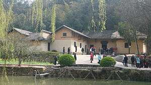 Mao Zedong's birthplace | |
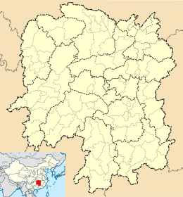 Shaoshan Location in Hunan | |
| Coordinates (Shaoshan government): 27°54′54″N 112°31′36″E | |
| Country | People's Republic of China |
| Province | Hunan |
| Prefecture-level city | Xiangtan |
| Seat | Qingxi Town |
| Area | |
| • County-level & Sub-prefectural city | 247.3 km2 (95.5 sq mi) |
| • Urban | 32.00 km2 (12.36 sq mi) |
| Population (2015) | |
| • County-level & Sub-prefectural city | 118,236 |
| • Density | 480/km2 (1,200/sq mi) |
| • Urban | 49,500 |
| Time zone | UTC+8 (China Standard) |
Located on the mid-eastern Hunan and the mid-north of Xiangtan, Shaoshan is bordered by Ningxiang County to the north, Xiangxiang City to the west and southwest, Xiangtan County to the east and southeast. It covers an area of 247.3 km2 (95.5 sq mi), as of 2015, it has a census registered population of 118,236 and a permanent resident population of 97,800.[2] It is the smallest administrative unit by size or by population in the counties and county-level cities in Hunan province.[3]
As the birthplace of Mao Zedong, the founder of the People's Republic of China, Shaoshan was an important base during the Chinese Communist Revolution. It is also the birthplace of Mao's Family Restaurant, a restaurant chain that has spread to many other cities. Red tourism to Shaoshan and other places related to China's communist background has driven the local economy, while increasing people's understanding of China's revolutionary history.
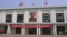
Mao remains a popular figure in the area.[4]
History
Shaoshan enjoys a long history. As the legend goes, there was once a king named Shundi who happened to pass here during his southward inspection. He was so fascinated with the landscape here that he played Shao Music (韶乐), which attracted many phoenixes and various birds to come to accompany. And Shaoshan was thus named after the Shao Music. It was under the jurisdiction of the state of Chu in the ancient times.[5]
On December 26, 1990, Shaoshan became a county-level city approved by the State Council.[5]
Names and administrative levels of Shaoshan:
- 1652 (Qing Dynasty): Qidu (七都), Xiangtan District (县)
- 1912 (Republic of China): The Second District (第二区), Xi Township (西乡), Xiangtan County
- December 1932: The Ninth District, Xiangtan County
- 1947: Qingtian Township, Xiangtan County
- January 1950 (People's Republic of China): The Third District, Xiangtan County
- 1951: The Fourth District, Xiangtan County
- August 1, 1955: Yintian District, Xiangtan County
- 1956: Yintian Town, Xiangtan County
- September 1, 1958: Shaoshan People's Commune, Xiangtan County
- May 12, 1961: Shaoshan District, Xiangtan County
- December 1968: county-controlled district status upgraded to regional district (地级区), controlled directly by the province
- December 1981: reverted to be county-controlled
- December 1984: upgraded to county-class district (县级区), controlled by Xiangtan City
- December 26, 1990: Upgraded to county-class city, controlled by Xiangtan City on behalf of the province.
Administrative divisions
After an adjustment of subdistrict divisions of Shaoshan City on 16 November 2015, Shaoshan City has two towns and two townships under its jurisdiction.[6] they are:
- 2 towns
- Qingxi, Shaoshan (清溪镇): Yongyi, Ruyi and the former Qingxi merged
- Yintian, Shaoshan (银田镇)
- 2 townships
- Shaoshan Township (韶山乡): Daping and the former Shaoshan Township merged
- Yanglin, Shaoshan (杨林乡)
Description
Population: the city consists of 100,000 residents, of which 16,000 are non-farmers. The total land area is 210 km2 (81 sq mi).
Geography: in the east-central hilly region of Hunan province, the geographical coordinates are longitude 112 ° 23'52 "-112 ° 38'13", latitude 27 ° 51'40 "-28 ° 1'53".
Shaoshan's topography is dominated by Mt. Shaofeng and the Shao and Shishi Rivers, with hills in the west giving rise to a mix of hills and plains in the east. The peak of Mount Shaofeng, 518.5 m above sea level, is the highest point whereas Liumuzhou, 48 m above sea level, is the lowest point of the whole city.
Sister cities
Geography
Climate
| Climate data for Shaoshan (1981−2010) | |||||||||||||
|---|---|---|---|---|---|---|---|---|---|---|---|---|---|
| Month | Jan | Feb | Mar | Apr | May | Jun | Jul | Aug | Sep | Oct | Nov | Dec | Year |
| Record high °C (°F) | 24.2 (75.6) |
30.1 (86.2) |
32.3 (90.1) |
35.0 (95.0) |
36.3 (97.3) |
37.2 (99.0) |
39.4 (102.9) |
40.8 (105.4) |
37.4 (99.3) |
35.0 (95.0) |
32.1 (89.8) |
24.4 (75.9) |
40.8 (105.4) |
| Average high °C (°F) | 8.4 (47.1) |
10.7 (51.3) |
14.9 (58.8) |
21.6 (70.9) |
26.6 (79.9) |
29.8 (85.6) |
33.3 (91.9) |
32.6 (90.7) |
28.2 (82.8) |
23.0 (73.4) |
17.5 (63.5) |
11.6 (52.9) |
21.5 (70.7) |
| Daily mean °C (°F) | 4.7 (40.5) |
6.9 (44.4) |
10.7 (51.3) |
17.0 (62.6) |
21.9 (71.4) |
25.3 (77.5) |
28.8 (83.8) |
27.7 (81.9) |
23.2 (73.8) |
17.9 (64.2) |
12.4 (54.3) |
6.9 (44.4) |
17.0 (62.5) |
| Average low °C (°F) | 2.1 (35.8) |
4.3 (39.7) |
7.7 (45.9) |
13.6 (56.5) |
18.3 (64.9) |
22.1 (71.8) |
25.2 (77.4) |
24.4 (75.9) |
20.0 (68.0) |
14.7 (58.5) |
9.0 (48.2) |
3.7 (38.7) |
13.8 (56.8) |
| Record low °C (°F) | −6.2 (20.8) |
−8.8 (16.2) |
−2.5 (27.5) |
1.4 (34.5) |
9.3 (48.7) |
13.2 (55.8) |
18.6 (65.5) |
16.7 (62.1) |
10.1 (50.2) |
2.4 (36.3) |
−1.6 (29.1) |
−12.1 (10.2) |
−12.1 (10.2) |
| Average precipitation mm (inches) | 69.0 (2.72) |
94.5 (3.72) |
131.7 (5.19) |
184.3 (7.26) |
195.0 (7.68) |
221.4 (8.72) |
124.6 (4.91) |
105.7 (4.16) |
79.3 (3.12) |
78.1 (3.07) |
72.7 (2.86) |
47.9 (1.89) |
1,404.2 (55.3) |
| Average relative humidity (%) | 82 | 82 | 83 | 82 | 82 | 84 | 77 | 81 | 83 | 81 | 79 | 78 | 81 |
| Source: China Meteorological Data Service Center[7] | |||||||||||||
References
- Ministry of Housing and Urban-Rural Development, ed. (2019). China Urban Construction Statistical Yearbook 2017. Beijing: China Statistics Press. p. 68. Retrieved 11 January 2020.
- 2015年韶山市国民经济和社会发展统计公报 [Statistical Communiqué of Shaoshan City on the 2015 National Economic and Social Development]. Xiangtan Bureau of Statistics. 2016-05-06. or xiangtan.gov.cn
- 湘潭市人民政府关于将湘乡市龙洞镇7个村和金石镇2个村成建制划归韶山市管辖的通知 (2012年4月25日-潭政发〔2012〕11号). Xiangtan People's Government.
- "In his hometown, Mao a source of pride." CNN. Tuesday September 29, 2009. Retrieved on September 30, 2009.
- He Qiuyun (贺秋云); Jiang Guoping (蒋国平); Qi Peigen (齐培根); Zhang Xinghuang (张星煌) (1991). "Foreword" 《序言》. 《中国韶山》 [China Shaoshan]. Fuzhou, Fujian: Huayi Publishing House. p. 1. ISBN 9787800392726.
- 湖南省民政厅关于同意韶山市乡镇区划调整方案的批复 (湘民行发〔2015〕24号) [result on adjustment of township-level administrative divisions of Shaoshan City on 16 November 2015]. rednet.cn Hunan. 2015-12-04., also see 湖南省乡镇区划调整改革109个县市区批复方案. people.com Hunan. 2015-12-08. or 湖南省乡镇区划调整改革109个县市区批复方案. Xinhua News. 2015-12-08.
- 中国地面气候标准值月值(1981-2010) (in Chinese). China Meteorological Data Service Center. Retrieved 20 October 2018.
External links
- Official site (in Chinese)
- Early Pictures of Mao ZeDong in Shaoshan
Hunan topics | |
|---|---|
Changsha (capital) | |
| General | |
| Geography |
|
| Education | |
| Culture | |
| Cuisine |
|
| Visitor attractions |
|
| |