Yopurga County
Yopurga[6][7][8] County (Uyghur: يوپۇرغا ناھىيىسى) is a county in northern Kashgar Prefecture, Xinjiang Uyghur Autonomous Region. More than 96% of the residents of the county are Uyghurs and live around oases at the western edge of the desolate Taklamakan Desert. The county is bordered to the north by Jiashi County, to the east by Maralbexi County, to the west by Shule County, to the southwest by Yengisar County and to the south by Yarkant County.[2]
Yopurga County يوپۇرغا ناھىيىسى 岳普湖县 Yopurgha, Yuepuhu, Yupogha, Yüeh-p'u-hu | |
|---|---|
County | |
.png) Location of the county in Kashgar Prefecture (yellow) and Xinjiang | |
 Yopurga Location of the county in Xinjiang | |
| Coordinates: | |
| Country | People's Republic of China |
| Autonomous region | Xinjiang |
| Prefecture | Kashgar |
| Seat | Yopurga Town (岳普湖镇)[1] |
| Township-level divisions | 4 towns, 5 townships |
| Area | |
| • Total | 3,128.09 km2 (1,207.76 sq mi) |
| Population (2010)[1] | |
| • Total | 147,688 |
| • Density | 47/km2 (120/sq mi) |
| Ethnic groups | |
| • Major ethnic groups | Uyghur[3][5] |
| Time zone | UTC+8 (China Standard) |
| Postal code | 844400 |
| Website | yph |
| Yopurga County | |||||||||||
|---|---|---|---|---|---|---|---|---|---|---|---|
| Uyghur name | |||||||||||
| Uyghur | يوپۇرغا ناھىيىسى | ||||||||||
| |||||||||||
| Chinese name | |||||||||||
| Simplified Chinese | 岳普湖县 | ||||||||||
| Traditional Chinese | 岳普湖縣 | ||||||||||
| |||||||||||
Name
Yopurga County is named for the Yopurga River (岳普湖河).[4]
History
In the Qing Dynasty, the area was part of Shule as Yopurga Zhuang (岳普尔湖庄).[1]
In 1940, Yopurga Shezhiju (岳普湖設治局) was created from portions of Shule County, Yengisar County, and Jiashi County. In 1943, Yopurga was made a county.[1][4]
On October 20, 2014, Terim (Tieremu) Township became Terim Town.[1]
On July 24, 2015, Yekshenbebazar (Yekexian Baibazha) was changed from a township to a town.[9]
According to Radio Free Asia, in March 2018, Yaqupjan Naman, a 17-year-old Uyghur boy who was detained for "traveling overseas", died of unknown causes at a local re-education camp and was buried by his father.[10] Ibrahim Kurban, a businessman from Kerim in Yopurga County who had been missing since 2016 en route to visit Turkey, was confirmed to have died at a re-education camp.[11]
Geography
Dawakol (Dawakun) National Desert Park (达瓦昆沙漠旅游风景区) is located in Yopurga County.[12]
Administrative divisions
As of 2019, Yopurga County included four towns, five townships and two other areas:[1][13][14]
Towns (بازىرى / 镇)
- Yopurga Town (Yopurgha, Yuepuhu; يوپۇرغا بازىرى / 岳普湖镇), Eshme[15] (Aiximan, Aiximai; ئەشمە بازىرى / 艾西曼镇 / 艾西买镇), Terim (Tieremu; تېرىم بازىرى / 铁热木镇, formerly تېرىم بازىرى / 铁热木乡), Yekshenbebazar (Yekexian Baibazha; يەكشەنبەبازار بازىرى / 也克先拜巴扎镇, formerly يەكشەنبەبازار بازىرى / 也克先拜巴扎乡)
Townships (يېزىسى / 乡)
- Yopurga Township (Yopurgha, Yuepuhu; يوپۇرغا يېزىسى / 岳普湖乡), Aqqik Township[16] (Aqike, Achchiq, A-ch'i-k'o; ئاچچىق يېزىسى[17] / 阿其克乡), Siyek Township[18] (Seyeke; سىيەك يېزىسى / 色也克乡), Bayawat Township (Bayi'awati; بايئاۋات يېزىسى / 巴依阿瓦提乡), Axunluqum Township (Ahong Lukumu, Ahonglukumu; ئاخۇنلۇقۇم يېزىسى / 阿洪鲁库木乡)
Other areas
- Yopurga Dairy Farm (岳普湖县奶牛场), Regiment 42 (兵团四十二团)
Economy
Agricultural products include wheat, cotton, corn, muskmelon, and oilseed products. Beekeeping is relatively developed. Herding is important, primarily sheep herding. Industries include cotton and hemp processing, food and oil processing, and concrete.[4]
Farmers in the county raise donkeys for meat, milk and donkey-hide gelatin.[19]
In July 1953, Yopurga County was reported to have 87,000 mou of winter and spring wheat.[20]
Demographics
| Historical population | ||
|---|---|---|
| Year | Pop. | ±% p.a. |
| 2000 | 129,441 | — |
| 2010 | 147,688 | +1.33% |
| [1] | ||
In 1997, Uyghurs made up 94.6% of the county's population.[5]
According to the 2002 census, it has a population of 130,000.
As of 2015, the population of Yopurga County was 96.1% Uyghur and 3.9% Han Chinese.[3] As of 2015, 167,860 of the 177,955 residents of the county were Uyghur, 9,801 were Han Chinese and 294 were from other ethnic groups.[21]
As of 1999, 94.68% of the population of Yopurga (Yuepuhu) County was Uyghur and 5.28% of the population was Han Chinese.[22]
Historical maps
Historical English-language maps including modern-day Yopurga County area:
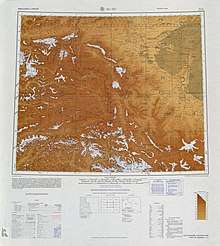 Map including Yopurga (labeled as YÜEH-P'U-HU (YUPOGHA)) and surrounding region from the International Map of the World (AMS, 1966)
 Map including Yopurga (labeled as YÜEH-P'U-HU) (DMA, 1974)
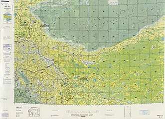 From the Operational Navigation Chart; map including Yopurga (Yüeh-p'u-hu) (DMA, 1980)[lower-alpha 1]
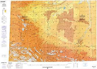 Map including Yopurga (Yüeh-p'u-hu) (DMA, 1984)[lower-alpha 2]
Notes
- From map: "The representation of international boundaries is not necessarily authoritative."
- From map: "The representation of international boundaries is not necessarily authoritative"
References
- 岳普湖县历史沿革 [Yopurga County Historical Evolution]. XZQH.org. 14 November 2014. Retrieved 10 March 2020.
清光绪年间为疏勒府本府五大回庄之一,称岳普尔湖庄。1941年由疏勒县析置岳普湖设治局,1943年升为岳普湖县,属喀什督察专区。{...}2000年第五次人口普查,岳普湖县常住总人口129441人,{...}2003年,岳普湖县总面积3165.76平方千米,{...}县政府驻岳普湖镇。{...}2010年第六次人口普查,岳普湖县常住总人口147688人,其中:岳普湖镇22092人,艾西曼镇14803人,岳普湖乡13461人,也克先拜巴扎乡18771人,阿其克乡21583人,色也克乡18064人,铁热木乡18971人,巴依阿瓦提乡10460人,阿洪鲁库木乡2524人,岳普湖县农场1137人,岳普湖县林场417人,岳普湖县奶牛场469人,岳普湖县良种场824人,岳普湖县大畜场486人,兵团四十二团3626人。 2014年10月20日,自治区政府(新政函[2014]179号)同意撤销铁热木乡,设立铁热木镇。调整后,全县辖3个镇、6个乡:岳普湖镇、艾西买镇、铁热木镇、岳普湖乡、也克先拜巴扎乡、阿其克乡、色也克乡、巴依阿瓦提乡、阿洪鲁库木乡。
- 自然地理. 岳普湖县人民政府 (in Chinese). Retrieved 11 March 2020.
岳普湖县隶属于新疆维吾尔自治区喀什地区;东邻巴楚县,南靠莎车县,西南与西部与疏勒县、英吉沙县毗邻,北部与伽师县相连,土地总面积3128.09平方公里。
- 岳普湖概况 [Yopurga Overview]. 岳普湖县人民政府. Retrieved 10 March 2020.
全县总面积3128平方公里。2015年,全县辖5乡4镇5个国营农林牧场,87个行政村,557个村民小组,7个社区;全县总人口17.4万人,其中,维吾尔族占96.1%,汉族和其他少数民族占3.9%。
- 夏征农; 陈至立, eds. (September 2009). 辞海:第六版彩图本 [Cihai (Sixth Edition in Color)] (in Chinese). Shanghai: Shanghai Lexicographical Publishing House. p. 2831. ISBN 9787532628599.
- 1997年岳普湖县行政区划. XZQH.org (in Chinese). 19 November 2010. Retrieved 10 March 2020.
面积3327.1平方千米,人口12.2万,有维吾尔、汉、回、蒙古、壮、满等民族,其中维吾尔族占94.6%
- Ministry of Housing and Urban-Rural Development (2010). 建筑抗震设计规范 [GB50011-2010: Code for Seismic Design of Buildings] (in English and Chinese). Beijing: China Architecture & Building Press. p. 203 – via Google Books.
Yopurga County
- Complete Atlas Of The World (3 ed.). Penguin Random House. 2016. p. 238 – via Internet Archive.
Yopurga
- Yopurga (Approved - N) at GEOnet Names Server, United States National Geospatial-Intelligence Agency
- 新疆维吾尔自治区人民政府关于同意岳普湖县也克先拜巴扎乡撤乡设镇的批复(新政函〔2015〕188号). 新疆民政 (in Chinese). 30 July 2015. Retrieved 11 March 2020.
- Shohret Hoshur, Joshua Lipes (19 April 2018). "Xinjiang Authorities Use 'Burial Management Centers' to Subvert Uyghur Funeral Traditions". Radio Free Asia. Translated by Alim Seytoff. Retrieved 11 March 2020.
Last month, authorities in Kashgar (Kashi) prefecture’s Yopurgha (Yuepuhu) county told RFA that a 17-year-old Uyghur boy named Yaqupjan Naman, who was detained for “traveling overseas,” had died of unknown causes at a local re-education camp. His father was not provided with the cause of the boy’s death and was forced to bury his body under police supervision, the sources said.
- Shohret Hoshur, Joshua Lipes (18 November 2019). "Uyghur Trader Who Went Missing in Xinjiang Ahead of Travel to Turkey Died in Detention". Radio Free Asia. Translated by Mamatjan Juma. Retrieved 11 March 2020.
A Uyghur trader, who went missing as he prepared to travel from northwest China’s Xinjiang Uyghur Autonomous Region (XUAR) to Turkey for business, died under mysterious circumstances in one of the region’s internment camps, according to sources.
- 达瓦昆沙漠旅游风景区. China National Tourism Administration (in Chinese). Retrieved 11 March 2020.
- 2019年统计用区划代码和城乡划分代码:岳普湖县 (in Chinese). National Bureau of Statistics of the People's Republic of China. 2019. Retrieved 10 March 2020.
统计用区划代码 名称 653128100000 岳普湖镇 653128101000 艾西曼镇 653128102000 铁热木镇 653128103000 也克先拜巴扎镇 653128200000 岳普湖乡 653128203000 阿其克乡 653128204000 色也克乡 653128206000 巴依阿瓦提乡 653128207000 阿洪鲁库木乡 653128402000 岳普湖县奶牛场 653128502000 兵团四十二团
- 岳普湖县乡镇、建制村名录及通硬化路、通客车情况表. 岳普湖县人民政府 (in Chinese). 20 June 2019. Retrieved 10 March 2020.
- Alessandra Cappelletti (2020). Socio-Economic Development in Xinjiang Uyghur Autonomous Region Disparities and Power Struggle in China's North-West. p. 243. ISBN 978-981-15-1536-1 – via Google Books.
- Aqqik (Approved - N) at GEOnet Names Server, United States National Geospatial-Intelligence Agency
- ئاچچىق (Variant Non-Roman Script - VS) at GEOnet Names Server, United States National Geospatial-Intelligence Agency
- "Reiche Ernte an roten Datteln in Xinjiang" (in German). Xinhua News Agency. 11 November 2016. Retrieved 10 March 2020.
Dorfbewohner verpacken rote Datteln für den Verkauf in der Gemeinde Siyek des Kreises Yopurga, des nordwestchinesischen Uigurischen Autonomen Gebiets Xinjiang, 9. November 2016.
- "Xinhua Insight: "Pairing assistance" program makes headway in Xinjiang amid challenges". Embassy of the People's Republic of China in the United States of America. 12 October 2013. Retrieved 11 March 2020.
With many local farmers raising donkeys, the Tai'an government built a breeding base in the county, procuring donkey meat, milk and donkey-hide gelatin from farmers, giving them an additional income of 10,000 yuan a year, said Chang.
- "CALAMITY DAMAGE AND CROP DATA, APRIL-OCTOBER 1953, EXTRACTED FROM CHINESE COMMUNIST PRESS" (PDF). CIA.gov. 23 February 1954. Archived from the original (PDF) on 3 June 2020. Retrieved 3 June 2020 – via Wikimedia Commons.
- 3-7 各地、州、市、县(市)分民族人口数 (in Chinese). شىنجاڭ ئۇيغۇر ئاپتونوم رايونى 新疆维吾尔自治区统计局 Statistic Bureau of Xinjiang Uygur Autonomous Region. Archived from the original on 2017-10-11. Retrieved 2017-09-03.
- Morris Rossabi, ed. (2004). Governing China’s Multiethnic Frontiers (PDF). University of Washington Press. p. 179. ISBN 0-295-98390-6.