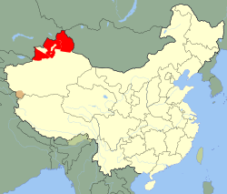
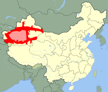
Xinjiang
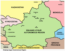
Xinjiang (Uyghur: شىنجاڭ , SASM/GNC: Xinjang; Chinese: 新疆; pinyin: Xīnjiāng; alternately romanized as Sinkiang), officially the Xinjiang Uyghur Autonomous Region[8] (XUAR), is an autonomous region of the People's Republic of China, located in the northwest of the country. Being the largest province-level division of China and the 8th largest country subdivision in the world, Xinjiang spans over 1.6 million km2 (640,000 square miles).[1] The Aksai Chin region, administered by China mostly as part of Xinjiang's Hotan Prefecture, is claimed by India. Xinjiang borders the countries of Mongolia (Bayan-Ölgii, Khovd and Govi-Altai Provinces), Russia (Altai Republic), Kazakhstan (East Kazakhstan and Almaty Provinces), Kyrgyzstan (Issyk Kul, Naryn and Osh Regions), Tajikistan (Gorno-Badakhshan Autonomous Region), Afghanistan (Badakhshan). The rugged Karakoram, Kunlun and Tian Shan mountain ranges occupy much of Xinjiang's borders, as well as its western and southern regions. Xinjiang also borders the Tibet Autonomous Region and the provinces of Gansu and Qinghai. The most well-known route of the historical Silk Road ran through the territory from the east to its northwestern border.
Xinjiang Uyghur Autonomous Region شىنجاڭ ئۇيغۇر ئاپتونوم رايونى 新疆维吾尔自治区 | |
|---|---|
| Name transcription(s) | |
| • Chinese | 新疆维吾尔自治区 (Xīnjiāng Wéiwú'ěr Zìzhìqū) |
| • Abbreviation | XJ / 新 (Pinyin: Xīn) |
| • Uyghur | شىنجاڭ ئۇيغۇر ئاپتونوم رايونى |
| • Uyghur transl. | Shinjang Uyghur Aptonom Rayoni |
     (clockwise from top)
| |
_(%2Ball_claims_hatched).svg.png) Map showing the location of the Xinjiang Uyghur Autonomous Region | |
| Coordinates: 41°N 85°E | |
| Named for | |
| Capital (and largest city) | Ürümqi |
| Divisions | 14 prefectures, 99 counties, 1005 townships |
| Government | |
| • Secretary | Chen Quanguo |
| • Chairman | Shohrat Zakir |
| Area | |
| • Total | 1,664,897 km2 (642,820 sq mi) |
| Area rank | 1st |
| Highest elevation (K2) | 8,611 m (28,251 ft) |
| Lowest elevation (Lake Ayding[2]) | −154 m (−505 ft) |
| Population (2010)[3] | |
| • Total | 21,815,815 |
| • Estimate (2018)[4] | 24,870,000 |
| • Rank | 25th |
| • Density | 15/km2 (40/sq mi) |
| • Density rank | 29th |
| Demographics | |
| • Ethnic composition | |
| • Languages and dialects | |
| ISO 3166 code | CN-XJ |
| GDP (2017 [6]) | CNY 1.1 trillion $162 billion (26th) |
| - per capita | CNY 45,099 USD 6,680 (21st) |
| HDI (2018) | 0.731[7] (high) (27th) |
| Website | Xinjiang Uyghur Autonomous Region |
In recent decades, abundant oil and mineral reserves have been found in Xinjiang and it is currently China's largest natural gas-producing region.
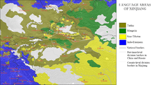
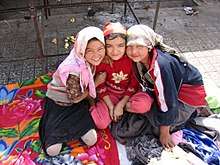
It is home to a number of ethnic groups, including the Turkic Uyghur, Kazakhs and Kyrgyz, the Han, Tibetans, Hui, Tajiks, Mongols, Russians and Xibe.[9] More than a dozen autonomous prefectures and counties for minorities are in Xinjiang. Older English-language reference works often refer to the area as Chinese Turkestan.[10] Xinjiang is divided into the Dzungarian Basin in the north and the Tarim Basin in the south by a mountain range. Only about 9.7% of Xinjiang's land area is fit for human habitation.[11]
With a documented history of at least 2,500 years, a succession of people and empires have vied for control over all or parts of this territory. The territory came under the rule of the Qing dynasty in the 18th century, later replaced by the Republic of China government. Since 1949, it has been part of the People's Republic of China following the Chinese Civil War. In 1954, Xinjiang Bingtuan was set up to strengthen the border defense against the Soviet Union and also promote the local economy. In 1955, Xinjiang was turned into an autonomous region from a province. In the last decades, the East Turkestan independent movement, separatist conflict and the influence of radical Islam have both resulted in unrest in the region, with occasional terrorist attacks and clashes between separatist and government forces.[12][13]
Names
| Xinjiang | |||||||||||||||||||||||||||||||||||||||||||||||||
|---|---|---|---|---|---|---|---|---|---|---|---|---|---|---|---|---|---|---|---|---|---|---|---|---|---|---|---|---|---|---|---|---|---|---|---|---|---|---|---|---|---|---|---|---|---|---|---|---|---|
.svg.png) "Xīnjiāng" in Chinese characters | |||||||||||||||||||||||||||||||||||||||||||||||||
| Chinese name | |||||||||||||||||||||||||||||||||||||||||||||||||
| Chinese | 新疆 | ||||||||||||||||||||||||||||||||||||||||||||||||
| Hanyu Pinyin | Xīnjiāng | ||||||||||||||||||||||||||||||||||||||||||||||||
| Postal | Sinkiang | ||||||||||||||||||||||||||||||||||||||||||||||||
| Literal meaning | "New Frontier" | ||||||||||||||||||||||||||||||||||||||||||||||||
| |||||||||||||||||||||||||||||||||||||||||||||||||
| Xinjiang Uyghur Autonomous Region | |||||||||||||||||||||||||||||||||||||||||||||||||
| Simplified Chinese | 新疆维吾尔自治区 | ||||||||||||||||||||||||||||||||||||||||||||||||
| Traditional Chinese | 新疆維吾爾自治區 | ||||||||||||||||||||||||||||||||||||||||||||||||
| Hanyu Pinyin | Xīnjiāng Wéiwú'ěr Zìzhìqū | ||||||||||||||||||||||||||||||||||||||||||||||||
| Postal | Sinkiang Uyghur Autonomous Region | ||||||||||||||||||||||||||||||||||||||||||||||||
| |||||||||||||||||||||||||||||||||||||||||||||||||
| Mongolian name | |||||||||||||||||||||||||||||||||||||||||||||||||
| Mongolian Cyrillic | Шиньжян Уйгурын өөртөө засах орон | ||||||||||||||||||||||||||||||||||||||||||||||||
| Mongolian script | ᠰᠢᠨᠵᠢᠶᠠᠩ ᠮᠤᠶᠢᠭᠤᠷ ᠮᠤᠨ ᠮᠥᠪᠡᠷᠲᠡᠭᠡᠨ ᠮᠵᠠᠰᠠᠬᠤ ᠮᠣᠷᠤᠨ | ||||||||||||||||||||||||||||||||||||||||||||||||
| |||||||||||||||||||||||||||||||||||||||||||||||||
| Uyghur name | |||||||||||||||||||||||||||||||||||||||||||||||||
| Uyghur | شىنجاڭ ئۇيغۇر ئاپتونوم رايونى | ||||||||||||||||||||||||||||||||||||||||||||||||
| |||||||||||||||||||||||||||||||||||||||||||||||||
| Manchu name | |||||||||||||||||||||||||||||||||||||||||||||||||
| Manchu script | ᡳᠴᡝ ᠵᡝᠴᡝᠨ ᡠᡳᡤᡠᡵ ᠪᡝᠶᡝ ᡩᠠᠰᠠᠩᡤᠠ ᡤᠣᠯᠣ | ||||||||||||||||||||||||||||||||||||||||||||||||
| Möllendorff | Ice Jecen Uigur beye dasangga golo | ||||||||||||||||||||||||||||||||||||||||||||||||
| Russian name | |||||||||||||||||||||||||||||||||||||||||||||||||
| Russian | Синьцзян | ||||||||||||||||||||||||||||||||||||||||||||||||
| Romanization | Sin'tsjan | ||||||||||||||||||||||||||||||||||||||||||||||||
| Kazakh name | |||||||||||||||||||||||||||||||||||||||||||||||||
| Kazakh | شينجياڭ ۇيعۇر اۆتونوميالى رايونى Shyńjań Uıǵyr aýtonomııalyq aýdany | ||||||||||||||||||||||||||||||||||||||||||||||||
| Kyrgyz name | |||||||||||||||||||||||||||||||||||||||||||||||||
| Kyrgyz | شئنجاڭ ۇيعۇر اپتونوم رايونۇ Шинжаң-Уйгур автоном району Şincañ-Uyğur avtonom rayonu | ||||||||||||||||||||||||||||||||||||||||||||||||
| Oirat name | |||||||||||||||||||||||||||||||||||||||||||||||||
| Oirat | ᠱᡅᠨᡓᡅᡕᠠᡊ ᡇᡕᡅᡎᡇᠷ ᡅᠨ ᡄᡋᡄᠷᡄᡃᠨ ᠴᠠᠰᠠᡍᡇ ᡆᠷᡇᠨ Šinǰiyang Uyiγur-in ebereen zasaqu orun | ||||||||||||||||||||||||||||||||||||||||||||||||
| Xibe name | |||||||||||||||||||||||||||||||||||||||||||||||||
| Xibe | ᠰᡞᠨᡪᠶᠠᡢ ᡠᡞᡤᡠᠷ ᠪᡝᠶᡝ ᡩᠠᠰᠠᡢᡤᠠ ᡤᠣᠯᠣ Sinjyang Uigur beye dasangga golo | ||||||||||||||||||||||||||||||||||||||||||||||||
The general region of Xinjiang has been known by many different names in earlier times, in indigenous languages as well as other languages. These names include Altishahr, the historical Uyghur name (referring to "the six cities" of the Tarim Basin), as well as Khotan, Khotay, Chinese Tartary, High Tartary, East Chagatay (it was the eastern part of the Chagatai Khanate), Moghulistan ("land of the Mongols"), Kashgaria, Little Bokhara, Serindia (due to Indian cultural influence)[14] and, in Chinese, "Western Regions".[15]
In Chinese, under the Han dynasty, Xinjiang was known as Xiyu (西域), meaning "Western Regions". Between the 2nd century BCE and 2nd century CE the Han Empire established the Protectorate of the Western Regions or Xiyu Protectorate (西域都護府) in an effort to secure the profitable routes of the Silk Road.[16] The Western Regions during the Tang era were known as Qixi (磧西). Qi refers to the Gobi Desert while Xi refers to the west. The Tang Empire had established the Protectorate General to Pacify the West or Anxi Protectorate (安西都護府) in 640 to control the region. During the Qing dynasty, the northern part of Xinjiang, Dzungaria was known as Zhunbu (準部, "Dzungar region") and the southern Tarim Basin was known as Huijiang (回疆, "Muslim Frontier") before both regions were merged and became the region of "Xiyu Xinjiang", later simplified as "Xinjiang".
The current Mandarin Chinese-derived name Xinjiang (Sinkiang), which literally means "New Frontier", "New Borderland" or "New Territory", was given during the Qing dynasty by the Qianlong Emperor.[17] According to Chinese statesman Zuo Zongtang's report to the Emperor of Qing, Xinjiang means an "old land newly returned" (故土新歸) or the "new old land".[note 1]
The term was also given to other areas conquered by Chinese empires, for instance, present-day Jinchuan County was known as "Jinchuan Xinjiang". In the same manner, present-day Xinjiang was known as Xiyu Xinjiang (Chinese: 西域新疆; lit.: 'Western Regions' New Frontier') and Gansu Xinjiang (Chinese: 甘肅新疆; lit.: 'Gansu Province's New Frontier', especially for present-day eastern Xinjiang).[19]
In 1955, Xinjiang Province was renamed "Xinjiang Uygur Autonomous Region". The name that was originally proposed was simply "Xinjiang Autonomous Region". Saifuddin Azizi, the first chairman of Xinjiang, registered his strong objections to the proposed name with Mao Zedong, arguing that "autonomy is not given to mountains and rivers. It is given to particular nationalities." As a result, the administrative region would be named "Xinjiang Uygur Autonomous Region".[20]
Description

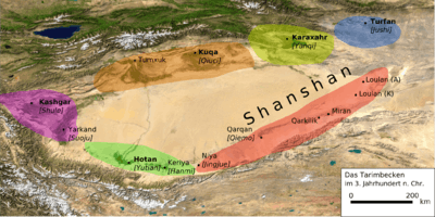
Xinjiang consists of two main geographically, historically and ethnically distinct regions with different historical names, Dzungaria north of the Tianshan Mountains and the Tarim Basin south of the Tianshan Mountains, before Qing China unified them into one political entity called Xinjiang Province in 1884. At the time of the Qing conquest in 1759, Dzungaria was inhabited by steppe dwelling, nomadic Tibetan Buddhist Dzungar people, while the Tarim Basin was inhabited by sedentary, oasis dwelling, Turkic-speaking Muslim farmers, now known as the Uyghur people. They were governed separately until 1884. The native Uyghur name for the Tarim Basin is Altishahr.
The Qing dynasty was well aware of the differences between the former Buddhist Mongol area to the north of the Tian Shan and the Turkic Muslim area south of the Tian Shan and ruled them in separate administrative units at first.[21] However, Qing people began to think of both areas as part of one distinct region called Xinjiang.[22] The very concept of Xinjiang as one distinct geographic identity was created by the Qing and it was originally not the native inhabitants who viewed it that way, but rather it was the Chinese who held that point of view.[23] During the Qing rule, no sense of "regional identity" was held by ordinary Xinjiang people; rather, Xinjiang's distinct identity was given to the region by the Qing, since it had distinct geography, history and culture, while at the same time it was created by the Chinese, multicultural, settled by Han and Hui and separated from Central Asia for over a century and a half.[24]
In the late 19th century, it was still being proposed by some people that two separate parts be created out of Xinjiang, the area north of the Tianshan and the area south of the Tianshan, while it was being argued over whether to turn Xinjiang into a province.[25]
Xinjiang is a large, sparsely populated area, spanning over 1.6 million km2 (comparable in size to Iran), which takes up about one sixth of the country's territory. Xinjiang borders the Tibet Autonomous Region and India's Leh District to the south and Qinghai and Gansu provinces to the southeast, Mongolia to the east, Russia to the north and Kazakhstan, Kyrgyzstan, Tajikistan, Afghanistan, Pakistan and India to the west.
The east-west chain of the Tian Shan separate Dzungaria in the north from the Tarim Basin in the south. Dzungaria is a dry steppe and the Tarim Basin contains the massive Taklamakan Desert, surrounded by oases. In the east is the Turpan Depression. In the west, the Tian Shan split, forming the Ili River valley.
History
Part of a series on the |
|---|
| History of Xinjiang |
 |
|
Medieval and early modern period |
Early history
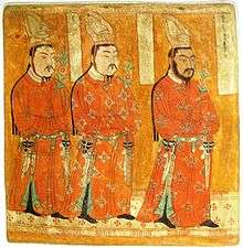
According to J. P. Mallory and Victor H. Mair, the Chinese describe the existence of "white people with long hair" or the Bai people in the Shan Hai Jing, who lived beyond their northwestern border.
The well-preserved Tarim mummies with Caucasoid features, often with reddish or blond hair,[26] today displayed at the Ürümqi Museum and dated to the 2nd millennium BC (4000 years ago), have been found in the same area of the Tarim Basin.[27] Between 2009–2015, the remains of 92 individuals found at the Xiaohe Tomb complex were analyzed for Y-DNA and mtDNA markers. Genetic analyses of the mummies showed that the maternal lineages of the Xiaohe people originated from both East Asia and West Eurasia, whereas the paternal lineages all originated from West Eurasia.[28]
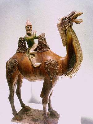
Various nomadic tribes, such as the Yuezhi, Saka, and Wusun were probably part of the migration of Indo-European speakers who were settled in eastern Central Asia (possibly as far as Gansu) at that time. The Ordos culture in northern China east of the Yuezhi, is another example. By the time the Han dynasty under Emperor Wu (r. 141–87 BC) wrestled the Western Regions of the Tarim Basin away from its previous overlords, the Xiongnu, it was inhabited by various peoples, such as Indo-European Tocharians in Turfan and Kucha and Indo-Iranian Saka peoples centered around Kashgar and Khotan.[29]
Nomadic cultures such as the Yuezhi (Rouzhi) are documented in the area of Xinjiang where the first known reference to the Yuezhi was made in 645 BC by the Chinese Guan Zhong in his work Guanzi (管子, Guanzi Essays: 73: 78: 80: 81). He described the Yúshì 禺氏 (or Niúshì 牛氏), as a people from the north-west who supplied jade to the Chinese from the nearby mountains (also known as Yushi) in Gansu.[30] The supply of jade[31] from the Tarim Basin from ancient times is well documented archaeologically: "It is well known that ancient Chinese rulers had a strong attachment to jade. All of the jade items excavated from the tomb of Fuhao of the Shang dynasty, more than 750 pieces, were from Khotan in modern Xinjiang. As early as the mid-first millennium BC, the Yuezhi engaged in the jade trade, of which the major consumers were the rulers of agricultural China."[32]
Traversed by the Northern Silk Road,[33] the Tarim and Dzungaria regions were known as the Western Regions. It was inhabited by various peoples, including Indo-European Tocharians in Turfan and Kucha and Indo-Iranian Saka peoples centered around Kashgar and Khotan.[29] At the beginning of the Han dynasty (206 BC-AD 220), the region was subservient to the Xiongnu, a powerful nomadic people based in modern Mongolia. In the 2nd century BC, the Han dynasty made preparations for war against Xiongnu when Emperor Wu of Han dispatched the explorer Zhang Qian to explore the mysterious kingdoms to the west and to form an alliance with the Yuezhi people in order to combat the Xiongnu. As a result of these battles, the Chinese controlled the strategic region from the Ordos and Gansu corridor to Lop Nor. They succeeded in separating the Xiongnu from the Qiang peoples to the south, and also gained direct access to the Western Regions. Han China sent Zhang Qian as an envoy to the states in the region, beginning several decades of struggle between the Xiongnu and Han China over dominance of the region, eventually ending in Chinese success. In 60 BC Han China established the Protectorate of the Western Regions (西域都護府) at Wulei (烏壘, near modern Luntai) to oversee the entire region as far west as the Pamir Mountains, which would remain under the influence and suzerainty of the Han dynasty with some interruptions. For instance, it fell out of their control during the civil war against Wang Mang (r. AD 9–23). It was brought back under Han control in AD 91 due to the efforts of the general Ban Chao.
The Western Jin dynasty succumbed to successive waves of invasions by nomads from the north at the beginning of the 4th century. The short-lived kingdoms that ruled northwestern China one after the other, including Former Liang, Former Qin, Later Liang, and Western Liáng, all attempted to maintain the protectorate, with varying degrees of success. After the final reunification of northern China under the Northern Wei empire, its protectorate controlled what is now the southeastern region of Xinjiang. Local states such as Shule, Yutian, Guizi and Qiemo controlled the western region, while the central region around Turpan was controlled by Gaochang, remnants of a state (Northern Liang) that once ruled part of what is now Gansu province in northwestern China.
During the Tang dynasty, a series of expeditions were conducted against the Western Turkic Khaganate, and their vassals, the oasis states of southern Xinjiang.[34] Campaigns against the oasis states began under Emperor Taizong with the annexation of Gaochang in 640.[35] The nearby kingdom of Karasahr was captured by the Tang in 644 and the kingdom of Kucha was conquered in 649.[36] The Tang Dynasty then established the Protectorate General to Pacify the West (安西都護府) or Anxi Protectorate in 640 to control the region.
During the devastating Anshi Rebellion, which nearly led to the destruction of the Tang dynasty, Tibet invaded the Tang on a wide front, from Xinjiang to Yunnan. It occupied the Tang capital of Chang'an in 763 for 16 days, and took control of southern Xinjiang by the end of the century. At the same time, the Uyghur Khaganate took control of northern Xinjiang, as well as much of Central Asia, and Mongolia.
As both Tibet and the Uyghur Khaganate declined in the mid-9th century, the Kara-Khanid Khanate, which was a confederation of Turkic tribes such as the Karluks, Chigils and Yaghmas,[37] took control of western Xinjiang in the 10th century and the 11th century. Meanwhile, after the Uyghur Khaganate in Mongolia had been smashed by the Kirghiz in 840, branches of the Uyghurs established themselves in Qocha (Karakhoja) and Beshbalik, near the modern cities of Turfan and Urumchi. This Uyghur state remained in eastern Xinjiang until the 13th century, though it was subject to foreign overlords during that time. The Kara-Khanids converted to Islam. The Uyghur state in eastern Xinjiang remained Manichaean, but later converted to Buddhism.
In 1132, remnants of the Liao dynasty from Manchuria entered Xinjiang, fleeing the rebellion of their neighbors, the Jurchens. They established a new empire, the Qara Khitai, which ruled over both the Kara-Khanid-held and Uyghur-held parts of the Tarim Basin for the next century. Although Khitan and Chinese were the primary languages of administration, the empire also administered in Persian and Uyghur.[38]
Islamisation of Xinjiang
| Part of a series on Islam in China | ||||||
|---|---|---|---|---|---|---|
 | ||||||
|
||||||
|
| ||||||
The historical area of what is contemporary Xinjiang consisted of the distinct areas of the Tarim Basin and Dzungaria and was originally populated by Indo-European Tocharian and Iranic Saka peoples who practiced the Buddhist religion. The Turfan and Tarim Basins were populated by speakers of Tocharian languages,[39] with "Europoid" mummies found in the region.[40] The area became Islamicised starting in the 10th centuries with the conversion of the Kara-Khanid Khanate who occupied Kashgar. Halfway through the 10th century the Saka Buddhist Kingdom of Khotan came under attack by the Turkic Muslim Karakhanid ruler Musa, and the Karakhanid leader Yusuf Qadir Khan conquered Khotan around 1006.[41]
Mongol period
After Genghis Khan unified Mongolia and began his advance west, the Uyghur state in the Turpan-Urumchi area offered its allegiance to the Mongols in 1209, contributing taxes and troops to the Mongol imperial effort. In return, the Uyghur rulers retained control of their kingdom. By contrast, Genghis Khan's Mongol Empire conquered the Qara Khitai in 1218.
Xinjiang was a stronghold of Ogedai and later came under the control of his descendant Kaidu. This branch of the Mongol family kept the Yuan dynasty at bay until their rule came to an end.
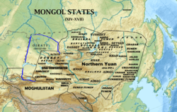
During the era of the Mongol Empire, the Yuan dynasty vied with the Chagatai Khanate for rule over the area, with the latter taking control of most of this region. After the break-up of the Chagatai Khanate into smaller khanates in the mid-14th century, the region fractured and was ruled by numerous Persianized Mongol Khans simultaneously, including the ones of Moghulistan (with the assistance of the local Dughlat Emirs), Uigurstan (later Turpan), and Kashgaria. These leaders engaged in wars with each other and the Timurids of Transoxania to the west and the Oirats to the east, the successor Chagatai regime based in Mongolia and in China. In the 17th century, the Dzungars established an empire over much of the region.
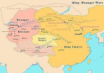
The Mongolian Dzungar was the collective identity of several Oirat tribes that formed and maintained one of the last nomadic empires. The Dzungar Khanate covered the area called Dzungaria and stretched from the west end of the Great Wall of China to present-day eastern Kazakhstan, and from present-day northern Kyrgyzstan to southern Siberia. Most of this area was only renamed "Xinjiang" by the Chinese after the fall of the Dzungar Empire. It existed from the early 17th century to the mid-18th century.
The Turkic Muslim sedentary people of the Tarim Basin were originally ruled by the Chagatai Khanate while the nomadic Buddhist Oirat Mongol in Dzungaria ruled over the Dzungar Khanate. The Naqshbandi Sufi Khojas, descendants of the Islamic prophet, Muhammad, had replaced the Chagatayid Khans as the ruling authority of the Tarim Basin in the early 17th century. There was a struggle between two factions of Khojas, the Afaqi (White Mountain) faction and the Ishaqi (Black Mountain) faction. The Ishaqi defeated the Afaqi, which resulted in the Afaq Khoja inviting the 5th Dalai Lama, the leader of the Tibetans, to intervene on his behalf in 1677. The 5th Dalai Lama then called upon his Dzungar Buddhist followers in the Dzungar Khanate to act on this invitation. The Dzungar Khanate then conquered the Tarim Basin in 1680, setting up the Afaqi Khoja as their puppet ruler.
After converting to Islam, the descendants of the previously Buddhist Uyghurs in Turfan failed to retain memory of their ancestral legacy and falsely believed that the "infidel Kalmuks" (Dzungars) were the ones who built Buddhist monuments in their area.[42]
Qing dynasty
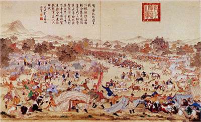
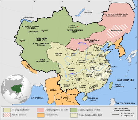
The Turkic Muslims of the Turfan and Kumul Oases then submitted to the Qing dynasty of China and asked China to free them from the Dzungars. The Qing accepted the rulers of Turfan and Kumul as Qing vassals. The Qing dynasty waged war against the Dzungars for decades until finally defeating them and then Qing Manchu Bannermen carried out the Dzungar genocide, nearly wiping them from existence and depopulating Dzungaria. The Qing then freed the Afaqi Khoja leader Burhan-ud-din and his brother Khoja Jihan from their imprisonment by the Dzungars, and appointed them to rule as Qing vassals over the Tarim Basin. The Khoja brothers decided to renege on this deal and declare themselves as independent leaders of the Tarim Basin. The Qing and the Turfan leader Emin Khoja crushed their revolt and China then took full control of both Dzungaria and the Tarim Basin by 1759.
The Manchu Qing dynasty of China gained control over eastern Xinjiang as a result of a long struggle with the Dzungars that began in the 17th century. In 1755, with the help of the Oirat noble Amursana, the Qing attacked Ghulja and captured the Dzungar khan. After Amursana's request to be declared Dzungar khan went unanswered, he led a revolt against the Qing. Over the next two years, Qing armies destroyed the remnants of the Dzungar Khanate and many Han Chinese and (Hui) moved into the pacified areas.[43]
The native Dzungar Oirat Mongols suffered heavily from the brutal campaigns and a simultaneous smallpox epidemic. One writer, Wei Yuan, described the resulting desolation in what is now northern Xinjiang as: "an empty plain for several thousand li, with no Oirat yurt except those surrendered."[44] It has been estimated that 80% of the 600,000 or more Dzungars were destroyed by a combination of disease and warfare,[45] and it took generations for it to recover.[46]
Han and Hui merchants were initially only allowed to trade in the Tarim Basin, while Han and Hui settlement in the Tarim Basin was banned, until the Muhammad Yusuf Khoja invasion, in 1830 when the Qing rewarded the merchants for fighting off Khoja by allowing them to settle down.[47] Robert Michell stated that in 1870 there were many Chinese of all occupations living in Dzungaria and they were well settled in the area, while in Turkestan (Tarim Basin) there were only a few Chinese merchants and soldiers in several garrisons among the Muslim population.[48]
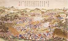
The Ush rebellion in 1765 by Uyghurs against the Manchus occurred after Uyghur women were gang raped by the servants and son of Manchu official Su-cheng.[49] It was said that Ush Muslims had long wanted to sleep on [Sucheng and son's] hides and eat their flesh. because of the rape of Uyghur Muslim women for months by the Manchu official Sucheng and his son.[50] The Manchu Emperor ordered that the Uyghur rebel town be massacred, the Qing forces enslaved all the Uyghur children and women and slaughtered the Uyghur men.[51] Manchu soldiers and Manchu officials regularly having sex with or raping Uyghur women caused massive hatred and anger by Uyghur Muslims to Manchu rule.[52]
_p61_PLATE19._SINKIANG_(14597194848).jpg)
After reconquering Xinjiang in the late 1870s from the Tajik adventurer Yaqub Beg, who had established independent emirate of Yettishar,[53] the Qing dynasty established Xinjiang ("new frontier") as a province in 1884,[54] formally applying to it the political systems of the rest of China and dropping the old names of Zhunbu (準部, Dzungar region) and Huijiang, "Muslimland".[55][56] After Xinjiang was converted into a province by the Qing, the provincialisation and reconstruction programs initiated by the Qing resulted in the Chinese government helping Uyghurs migrate from Southern Xinjiang to other areas of the province, like the area between Qitai and the capital, which was formerly nearly completely inhabited by Han Chinese and other areas like Ürümqi, Tacheng (Tabarghatai), Yili, Jinghe, Kur Kara Usu, Ruoqiang, Lop Nor and the Tarim River's lower reaches.[57] It was during Qing times that Uyghurs were settled throughout all of Xinjiang, from their original home cities in the Western Tarim Basin.
Republic of China
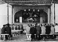
In 1912, the Qing dynasty was replaced by the Republic of China. Yuan Dahua, the last Qing governor of Xinjiang, fled. One of his subordinates, Yang Zengxin, took control of the province and acceded in name to the Republic of China in March of the same year. Through a balancing of mixed ethnic constituencies, Yang maintained control over Xinjiang until his assassination in 1928 after the Northern Expedition of the Kuomintang.[58]
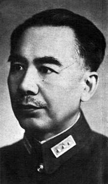
The Kumul Rebellion and other rebellions arose against his successor Jin Shuren in the early 1930s throughout Xinjiang, involving Uyghurs, other Turkic groups, and Hui (Muslim) Chinese. Jin drafted White Russians to crush the revolt. In the Kashgar region on 12 November 1933, the short-lived self-proclaimed First East Turkestan Republic was declared, after some debate over whether the proposed independent state should be called "East Turkestan" or "Uyghuristan".[59][60] The region claimed by the ETR in theory encompassed Kashgar, Khotan and Aqsu prefectures in southwestern Xinjiang.[61] The Chinese Muslim Kuomintang 36th Division (National Revolutionary Army) destroyed the army of the First East Turkestan Republic at the Battle of Kashgar (1934), bringing the Republic to an end after the Chinese Muslims executed the two Emirs of the Republic, Abdullah Bughra and Nur Ahmad Jan Bughra. The Soviet Union invaded the province in the Soviet Invasion of Xinjiang. In the Xinjiang War (1937), the entire province was brought under the control of northeast Han warlord Sheng Shicai, who ruled Xinjiang for the next decade with close support from the Soviet Union, many of whose ethnic and security policies Sheng instituted in Xinjiang. The Soviet Union maintained a military base in Xinjiang and had several military and economic advisors deployed in the region. Sheng invited a group of Chinese Communists to Xinjiang, including Mao Zedong's brother Mao Zemin, but in 1943, fearing a conspiracy, Sheng executed them all, including Mao Zemin. In 1944, then the President and Premier of China Chiang Kai-shek, was informed of Shicai's intention of joining the Soviet Union by Soviets, decided to shift him out of Xinjiang to Chongqing as the Minister of Agriculture and Forest.[62] More than one decade of Sheng's era had stopped. However, a short-lived Soviet-backed Second East Turkestan Republic was established in that year, which lasted until 1949 in what is now Ili Kazakh Autonomous Prefecture (Ili, Tarbagatay and Altay Districts) in northern Xinjiang.
People's Republic of China
During the Ili Rebellion the Soviet Union backed Uyghur separatists to form the Second East Turkestan Republic (2nd ETR) in Ili region while the majority of Xinjiang was under Republic of China Kuomintang control.[59] The People's Liberation Army entered Xinjiang in 1949, then the Kuomintang commander Tao Zhiyue and the government's chairman Burhan Shahidi surrendered the province to them.[60] Five ETR leaders who were to negotiate with the Chinese over the ETR's sovereignty died in an air crash in 1949 in Soviet airspace over the Kazakh Soviet Socialist Republic.[63]
The autonomous region of the PRC was established on 1 October 1955, replacing the province.[60] In 1955 (the first modern census in China was taken in 1953), Uyghurs were counted as 73% of Xinjiang's total population of 5.11 million.[20] Although Xinjiang as a whole is designated as an "Uyghur Autonomous Region" since 1954 more than 50% of Xinjiang's land area are designated autonomous areas for 13 native non-Uyghur groups.[64] The modern Uyghur people experienced ethnogenesis especially from 1955, when the PRC officially recognized that ethnic category – in opposition to the Han – of formerly separately self-identified oasis peoples.[65]
Southern Xinjiang is home to the majority of the Uyghur population (about nine million people). The majority of the Han (90%) population of Xinjiang, which is mostly urban, are in Northern Xinjiang.[66][67] This situation has been followed by an imbalance in the economic situation between the two ethnic groups, since the Northern Junghar Basin (Dzungaria) has been more developed than the Uyghur south.[68]
Since China's economic reform from the late 1970s has exacerbated uneven regional development, more Uyghurs have migrated to Xinjiang cities and some Hans have also migrated to Xinjiang for independent economic advancement. Deng Xiaoping made a nine-day visit to Xinjiang in 1981, describing the region as "unsteady".[69] Increased ethnic contact and labor competition coincided with Uyghur separatist terrorism from the 1990s, such as the 1997 Ürümqi bus bombings.[70]
In 2000, Uyghurs comprised 45% of Xinjiang's population, but only 13% of Ürümqi's population. Despite having 9% of Xinjiang's population, Ürümqi accounts for 25% of the region's GDP, and many rural Uyghurs have been migrating to that city to seek work in the dominant light, heavy, and petrochemical industries.[71] Hans in Xinjiang are demographically older, better-educated, and work in higher-paying professions than their Uyghur cohabitants. Hans are more likely to cite business reasons for moving to Ürümqi, while some Uyghurs also cite trouble with the law back home and family reasons for their moving to Ürümqi.[72] Hans and Uyghurs are equally represented in Ürümqi's floating population that works mostly in commerce. Self-segregation within the city is widespread, in terms of residential concentration, employment relationships, and a social norm of endogamy.[73] In 2010, Uyghurs constituted a majority in the Tarim Basin, and a mere plurality in Xinjiang as a whole.[74]
Xinjiang has been a focal point of ethnic and other tensions:[75][76] incidents include the 2007 Xinjiang raid,[77] a thwarted 2008 suicide bombing attempt on a China Southern Airlines flight,[78] and the 2008 Xinjiang attack which resulted in the deaths of sixteen police officers four days before the Beijing Olympics.[79][80]
Culturally, Xinjiang maintains 81 public libraries and 23 museums, compared to none of each in 1949, and Xinjiang has 98 newspapers in 44 languages, up from 4 newspapers in 1952. According to official statistics, the ratios of doctors, medical workers, medical clinics, and hospital beds to people surpass the national average, and immunization rates have reached 85%.[81]
Administrative divisions
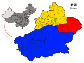
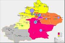
Xinjiang is divided into thirteen prefecture-level divisions: four prefecture-level cities, six prefectures and five autonomous prefectures (including the sub-provincial autonomous prefecture of Ili, which in turn has two of the seven prefectures within its jurisdiction) for Mongol, Kazakh, Kyrgyz and Hui minorities. At the end of the year 2017, the total population of Xinjiang is 24.45 million.[82]
These are then divided into 13 districts, 25 county-level cities, 62 counties and 6 autonomous counties. Ten of the county-level cities do not belong to any prefecture and are de facto administered by the Xinjiang Production and Construction Corps. Sub-level divisions of the Xinjiang Uyghur Autonomous Region is shown in the adjacent picture and described in the table below:
| Administrative divisions of Xinjiang | |||||||||||||
|---|---|---|---|---|---|---|---|---|---|---|---|---|---|
.svg.png) █ XPCC / Bingtuan administered
county-level divisions █ Subordinate to Ili Kazakh A.P.
☐ Disputed areas claimed by India
and administered by China (see Sino-Indian border dispute) | |||||||||||||
| Division code[83] | Division | Area in km2[84] | Population 2010[85] | Seat | Divisions[86] | ||||||||
| Districts | Counties | Aut. counties | CL cities | ||||||||||
| 650000 | Xinjiang Uyghur Autonomous Region | 1664900.00 | 21,813,334 | Ürümqi city | 13 | 61 | 6 | 26 | |||||
| 650100 | Ürümqi city | 13787.90 | 3,110,280 | Tianshan District | 7 | 1 | |||||||
| 650200 | Karamay city | 8654.08 | 391,008 | Karamay District | 4 | ||||||||
| 650400 | Turpan city | 67562.91 | 622,679 | Gaochang District | 1 | 2 | |||||||
| 650500 | Hami city | 142094.88 | 572,400 | Yizhou District | 1 | 1 | 1 | ||||||
| 652300 | Changji Hui Autonomous Prefecture | 73139.75 | 1,428,592 | Changji city | 4 | 1 | 2 | ||||||
| 652700 | Bortala Mongol Autonomous Prefecture | 24934.33 | 443,680 | Bole city | 2 | 2 | |||||||
| 652800 | Bayingolin Mongol Autonomous Prefecture | 470954.25 | 1,278,492 | Korla city | 7 | 1 | 1 | ||||||
| 652900 | Aksu Prefecture | 127144.91 | 2,370,887 | Aksu city | 7 | 2 | |||||||
| 653000 | Kizilsu Kyrgyz Autonomous Prefecture | 72468.08 | 525,599 | Artux city | 3 | 1 | |||||||
| 653100 | Kashgar Prefecture | 137578.51 | 3,979,362 | Kashi city | 10 | 1 | 1 | ||||||
| 653200 | Hotan Prefecture | 249146.59 | 2,014,365 | Hotan city | 7 | 1 | |||||||
| 654000 | Ili Kazakh Autonomous Prefecture | 56381.53 * | 2,482,627 * | Yining city | 7 * | 1 * | 3 * | ||||||
| 654200 | Tacheng Prefecture* | 94698.18 | 1,219,212 | Tacheng city | 4 | 1 | 2 | ||||||
| 654300 | Altay Prefecture* | 117699.01 | 526,980 | Altay city | 6 | 1 | |||||||
| 659000 | Xinjiang Production and Construction Corps | 13055.57 | 1,481,165 | Ürümqi city | 10 | ||||||||
| 659001 | Shihezi city (8th Division) | 456.84 | 635,582 | Hongshan Subdistrict | 1 | ||||||||
| 659002 | Aral city (1st Division) | 5266.00 | 190,613 | Jinyinchuan Road Subdistrict | 1 | ||||||||
| 659003 | Tumxuk city (3rd Division) | 2003.00 | 174,465 | Qiganquele Subdistrict | 1 | ||||||||
| 659004 | Wujiaqu city (6th Division) | 742.00 | 90,205 | Renmin Road Subdistrict | 1 | ||||||||
| 659005 | Beitun city (10th Division) | 910.50 | 86,300 | Xincheng Subdistrict | 1 | ||||||||
| 659006 | Tiemenguan city (2nd Division) | 590.27 | 50,000 | Chengqu Subdistrict | 1 | ||||||||
| 659007 | Shuanghe city (5th Division) | 742.18 | 53,800 | Tasierhai town | 1 | ||||||||
| 659008 | Kokdala city (4th Division) | 979.71 | 75,000 | Jieliangzi Subdistrict | 1 | ||||||||
| 659009 | Kunyu city (14th Division) | 687.13 | 45,200 | Kunyu town | 1 | ||||||||
| 659010 | Huyanghe city (7th Division) | 677.94 | 80,000 | Gongqing town | 1 | ||||||||
Sub-provincial prefecture
* – Altay Prefecture or Tacheng Prefecture are subordinate to Ili Prefecture. / The population or area figures of Ili do not include Altay Prefecture or Tacheng Prefecture which are subordinate to Ili Prefecture. | |||||||||||||
| Administrative divisions in Uyghur, Chinese and varieties of romanizations | ||||
|---|---|---|---|---|
| English | Uyghur | SASM/GNC Uyghur Pinyin | Chinese | Pinyin |
| Xinjiang Uyghur Autonomous Region | شىنجاڭ ئۇيغۇر ئاپتونوم رايونى | Xinjang Uyĝur Aptonom Rayoni | 新疆维吾尔自治区 | Xīnjiāng Wéiwú'ěr Zìzhìqū |
| Ürümqi city | ئۈرۈمچى شەھىرى | Ürümqi Xäĥiri | 乌鲁木齐市 | Wūlǔmùqí Shì |
| Karamay city | قاراماي شەھىرى | K̂aramay Xäĥiri | 克拉玛依市 | Kèlāmǎyī Shì |
| Turpan city | تۇرپان شەھىرى | Turpan Xäĥiri | 吐鲁番市 | Tǔlǔfān Shì |
| Hami city | قۇمۇل شەھىرى | K̂umul Xäĥiri | 哈密市 | Hāmì Shì |
| Changji Hui Autonomous Prefecture | سانجى خۇيزۇ ئاپتونوم ئوبلاستى | Sanji Huyzu Aptonom Oblasti | 昌吉回族自治州 | Chāngjí Huízú Zìzhìzhōu |
| Bortala Mongol Autonomous Prefecture | بۆرتالا موڭغۇل ئاپتونوم ئوبلاستى | Börtala Mongĝul Aptonom Oblasti | 博尔塔拉蒙古自治州 | Bó'ěrtǎlā Měnggǔ Zìzhìzhōu |
| Bayingolin Mongol Autonomous Prefecture | بايىنغولىن موڭغۇل ئاپتونوم ئوبلاستى | Bayinĝolin Mongĝul Aptonom Oblasti | 巴音郭楞蒙古自治州 | Bāyīnguōlèng Měnggǔ Zìzhìzhōu |
| Aksu Prefecture | ئاقسۇ ۋىلايىتى | Ak̂su Vilayiti | 阿克苏地区 | Ākèsū Dìqū |
| Kizilsu Kirghiz Autonomous Prefecture | قىزىلسۇ قىرغىز ئاپتونوم ئوبلاستى | K̂izilsu K̂irĝiz Aptonom Oblasti | 克孜勒苏柯尔克孜自治州 | Kèzīlèsū Kē'ěrkèzī Zìzhìzhōu |
| Kashi Prefecture | قەشقەر ۋىلايىتى | K̂äxk̂är Vilayiti | 喀什地区 | Kāshí Dìqū |
| Hotan Prefecture | خوتەن ۋىلايىتى | Hotän Vilayiti | 和田地区 | Hétián Dìqū |
| Ili Kazakh Autonomous Prefecture | ئىلى قازاق ئاپتونوم ئوبلاستى | Ili K̂azak̂ Aptonom Oblasti | 伊犁哈萨克自治州 | Yīlí Hāsàkè Zìzhìzhōu |
| Tacheng Prefecture | تارباغاتاي ۋىلايىتى | Tarbaĝatay Vilayiti | 塔城地区 | Tǎchéng Dìqū |
| Altay Prefecture | ئالتاي ۋىلايىتى | Altay Vilayiti | 阿勒泰地区 | Ālètài Dìqū |
| Shihezi city | شىخەنزە شەھىرى | Xihänzä Xäĥiri | 石河子市 | Shíhézǐ Shì |
| Aral city | ئارال شەھىرى | Aral Xäĥiri | 阿拉尔市 | Ālā'ěr Shì |
| Tumxuk city | تۇمشۇق شەھىرى | Tumxuk̂ Xäĥiri | 图木舒克市 | Túmùshūkè Shì |
| Wujiaqu city | ۋۇجياچۈ شەھىرى | Vujyaqü Xäĥiri | 五家渠市 | Wǔjiāqú Shì |
| Beitun city | بەيتۈن شەھىرى | Bäatün Xäĥiri | 北屯市 | Běitún Shì |
| Tiemenguan city | باشئەگىم شەھىرى | Baxägym Xäĥiri | 铁门关市 | Tiĕménguān Shì |
| Shuanghe city | قوشئۆگۈز شەھىرى | K̂oxögüz Xäĥiri | 双河市 | Shuānghé Shì |
| Kokdala city | كۆكدالا شەھىرى | Kökdala Xäĥiri | 可克达拉市 | Kěkèdálā Shì |
| Kunyu city | قۇرۇمقاش شەھىرى | Kurumkax Xäĥiri | 昆玉市 | Kūnyù Shì |
| Huyanghe city | خۇياڭخې شەھىرى | Huyanghê Xäĥiri | 胡杨河市 | Húyánghé Shì |
Urban areas
| Population by urban areas of prefecture & county cities | |||||
|---|---|---|---|---|---|
| # | City | Urban area[87] | District area[87] | City proper[87] | Census date |
| 1 | Ürümqi | 2,853,398 | 3,029,372 | 3,112,559 | 2010-11-01 |
| 2 | Korla | 425,182 | 549,324 | part of Bayingolin Prefecture | 2010-11-01 |
| 3 | Yining | 368,813 | 515,082 | part of Ili Prefecture | 2010-11-01 |
| 4 | Karamay | 353,299 | 391,008 | 391,008 | 2010-11-01 |
| 5 | Shihezi | 313,768 | 380,130 | 380,130 | 2010-11-01 |
| 6 | Hami[lower-roman 1] | 310,500 | 472,175 | 572,400 | 2010-11-01 |
| 7 | Kashi | 310,448 | 506,640 | part of Kashi Prefecture | 2010-11-01 |
| 8 | Changji | 303,938 | 426,253 | part of Changji Prefecture | 2010-11-01 |
| 9 | Aksu | 284,872 | 535,657 | part of Aksu Prefecture | 2010-11-01 |
| 10 | Usu | 131,661 | 298,907 | part of Tacheng Prefecture | 2010-11-01 |
| 11 | Bole | 120,138 | 235,585 | part of Bortala Prefecture | 2010-11-01 |
| 12 | Hotan | 119,804 | 322,300 | part of Hotan Prefecture | 2010-11-01 |
| 13 | Altay | 112,711 | 190,064 | part of Altay Prefecture | 2010-11-01 |
| 14 | Turpan[lower-roman 2] | 89,719 | 273,385 | 622,903 | 2010-11-01 |
| 15 | Tacheng | 75,122 | 161,037 | part of Tacheng Prefecture | 2010-11-01 |
| 16 | Wujiaqu | 75,088 | 96,436 | 96,436 | 2010-11-01 |
| 17 | Fukang | 67,598 | 165,006 | part of Changji Prefecture | 2010-11-01 |
| 18 | Aral | 65,175 | 158,593 | 158,593 | 2010-11-01 |
| 19 | Artux | 58,427 | 240,368 | part of Kizilsu Prefecture | 2010-11-01 |
| (–) | Beitun[lower-roman 3] | 57,889 | 57,889 | 57,889 | 2010-11-01 |
| (–) | Kokdala[lower-roman 4] | 57,537 | 57,537 | 57,537 | 2010-11-01 |
| (–) | Shuanghe[lower-roman 5] | 53,565 | 53,565 | 53,565 | 2010-11-01 |
| (–) | Korgas[lower-roman 6] | 51,462 | 51,462 | part of Ili Prefecture | 2010-11-01 |
| (–) | Kunyu[lower-roman 7] | 36,399 | 36,399 | 36,399 | 2010-11-01 |
| 20 | Tumxuk | 34,808 | 135,727 | 135,727 | 2010-11-01 |
| (–) | Tiemenguan[lower-roman 8] | 30,244 | 30,244 | 30,244 | 2010-11-01 |
| 21 | Kuytun | 20,805 | 166,261 | part of Ili Prefecture | 2010-11-01 |
| (–) | Alashankou[lower-roman 9] | 15,492 | 15,492 | part of Bortala Prefecture | 2010-11-01 |
- Hami Prefecture is currently known as Hami PLC after census; Hami CLC is currently known as Yizhou after census.
- Turpan Prefecture is currently known as Turpan PLC after census; Turpan CLC is currently known as Gaochang after census.
- Beitun CLC was established from parts of Altay CLC after census.
- Kokdala CLC was established from parts of Huocheng County after census.
- Shuanghe CLC was established from parts of Bole CLC after census.
- Korgas CLC was established from parts of Huocheng County after census.
- Kunyu CLC was established from parts of Hotan County, Pishan County, Moyu County, & Qira County after census.
- Tiemenguan CLC was established from parts of Korla CLC after census.
- Alashankou CLC was established from parts of Bole CLC & Jinghe County after census.
Geography and geology
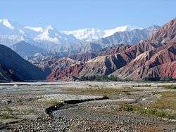
Xinjiang is the largest political subdivision of China—it accounts for more than one sixth of China's total territory and a quarter of its boundary length. Xinjiang is mostly covered with uninhabitable deserts and dry grasslands, with dotted oases at the foot of Tian Shan, Kunlun Mountains and Altai Mountains. The inhabitable oasis accounts for 9.7% of Xinjiang's total area by 2015.[11]
Mountain systems and basins
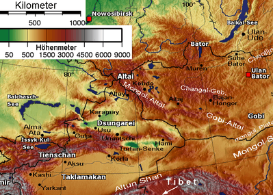
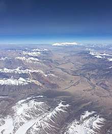
Xinjiang is split by the Tian Shan mountain range (تەڭرى تاغ, Tengri Tagh, Тәңри Тағ), which divides it into two large basins: the Dzungarian Basin in the north and the Tarim Basin in the south. A small V-shaped wedge between these two major basins, limited by the Tian Shan's main range in the south and the Borohoro Mountains in the north, is the basin of the Ili River, which flows into Kazakhstan's Lake Balkhash; an even smaller wedge farther north is the Emin Valley.
Other major mountain ranges of Xinjiang include the Pamir Mountains and Karakoram in the southwest, the Kunlun Mountains in the south (along the border with Tibet) and the Altai Mountains in the northeast (shared with Mongolia). The region's highest point is the mountain K2, 8611 metres above sea level, in the Karakoram Mountains on the border with Pakistan.
Much of the Tarim Basin is dominated by the Taklamakan Desert. North of it is the Turpan Depression, which contains the lowest point in Xinjiang and in the entire PRC, at 155 metres below sea level.
The Dzungarian Basin is slightly cooler, and receives somewhat more precipitation, than the Tarim Basin. Nonetheless, it, too, has a large Gurbantünggüt Desert (also known as Dzoosotoyn Elisen) in its center.
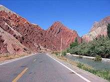
The Tian Shan mountain range marks the Xinjiang-Kyrgyzstan border at the Torugart Pass (3752 m). The Karakorum highway (KKH) links Islamabad, Pakistan with Kashgar over the Khunjerab Pass.
Geology
Xinjiang is young geologically. Collision of the Indian and the Eurasian plates formed the Tian Shan, Kunlun Shan, and Pamir mountain ranges. Xinjiang is a very active earthquake zone. Older geological formations are located in the far north, where the Junggar Block is geologically part of Kazakhstan, and in the east, where is part of the North China Craton.
Center of the continent
Xinjiang has within its borders, in the Dzoosotoyn Elisen Desert, the location in Eurasia that is furthest from the sea in any direction (a continental pole of inaccessibility): 46°16.8′N 86°40.2′E. It is at least 2,647 km (1,645 mi) (straight-line distance) from any coastline.
In 1992, local geographers determined another point within Xinjiang – 43°40′52″N 87°19′52″E in the southwestern suburbs of Ürümqi, Ürümqi County – to be the "center point of Asia". A monument to this effect was then erected there and the site has become a local tourist attraction.[88]
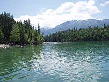
Rivers and lakes
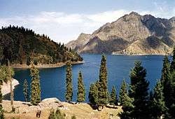
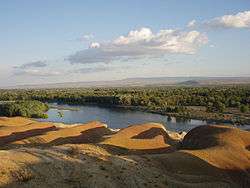
Having hot summer and low precipitation, most of Xinjiang is endorheic. Its rivers either disappear in the desert, or terminate in salt lakes (within Xinjiang itself, or in neighboring Kazakhstan), instead of running towards an ocean. The northernmost part of the region, with the Irtysh River rising in the Altai Mountains, that flows (via Kazakhstan and Russia) toward the Arctic Ocean, is the only exception. But even so, a significant part of the Irtysh's waters were artificially diverted via the Irtysh–Karamay–Ürümqi Canal to the drier regions of southern Dzungarian Basin.
Elsewhere, most of Xinjiang's rivers are comparatively short streams fed by the snows of the several ranges of the Tian Shan. Once they enter the populated areas in the mountains' foothills, their waters are extensively used for irrigation, so that the river often disappears in the desert instead of reaching the lake to whose basin it nominally belongs. This is the case even with the main river of the Tarim Basin, the Tarim, which has been dammed at a number of locations along its course, and whose waters have been completely diverted before they can reach the Lop Lake. In the Dzungarian basin, a similar situation occurs with most rivers that historically flowed into Lake Manas. Some of the salt lakes, having lost much of their fresh water inflow, are now extensively use for the production of mineral salts (used e.g., in the manufacturing of potassium fertilizers); this includes the Lop Lake and the Manas Lake.
Time
Xinjiang is in the same time zone as the rest of China, Beijing time, UTC+8. But while Xinjiang being about two time zones west of Beijing, some residents, local organizations and governments watch another time standard known as Xinjiang Time, UTC+6.[89] Han people tend to use Beijing Time, while Uyghurs tend to use Xinjiang Time as a form of resistance to Beijing.[90] But, regardless of the time standard preferences, most businesses, schools open and close two hours later than in the other regions of China.[91]
Deserts
Deserts include:
- Gurbantünggüt Desert, also known as Dzoosotoyn Elisen
- Taklamakan Desert
- Kumtag Desert, east of Taklamakan
Major cities
Due to the water situation, most of Xinjiang's population lives within fairly narrow belts that are stretched along the foothills of the region's mountain ranges, where irrigated agriculture can be practised. It is in these belts where most of the region's cities are found.
Climate
A semiarid or desert climate (Köppen BSk or BWk, respectively) prevails in Xinjiang. The entire region has great seasonal differences in temperature with cold winters. The Turpan Depression recorded the hottest temperatures nationwide in summer,[92] with air temperatures easily exceeding 40 °C (104 °F). Winter temperatures regularly fall below −20 °C (−4 °F) in the far north and highest mountain elevations.
Continuous permafrost is typically found in the Tian Shan starting at the elevation of about 3,500–3,700 m above sea level. Discontinuous alpine permafrost usually occurs down to 2,700–3,300 m, but in certain locations, due to the peculiarity of the aspect and the microclimate, it can be found at elevations as low as 2,000 m.[93]
Politics
.jpg)
- Secretaries of the CPC Xinjiang Committee
- 1949–1952 Wang Zhen (王震)
- 1952–1967 Wang Enmao (王恩茂)
- 1970–1972 Long Shujin (龙书金)
- 1972–1978 Saifuddin Azizi (赛福鼎·艾则孜; سەيپىدىن ئەزىزى)
- 1978–1981 Wang Feng (汪锋)
- 1981–1985 Wang Enmao (王恩茂)
- 1985–1994 Song Hanliang (宋汉良)
- 1994–2010 Wang Lequan (王乐泉)
- 2010–2016 Zhang Chunxian (张春贤)
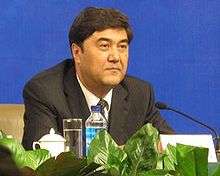
- 2016–present Chen Quanguo (陈全国)
- Chairmen of the Xinjiang Government
- 1949–1955 Burhan Shahidi (包尔汉·沙希迪; بۇرھان شەھىدى)
- 1955–1967 Saifuddin Azizi (赛福鼎·艾则孜; سەيپىدىن ئەزىزى)
- 1968–1972 Long Shujin (龙书金)
- 1972–1978 Saifuddin Azizi (赛福鼎·艾则孜; سەيپىدىن ئەزىزى)
- 1978–1979 Wang Feng (汪锋)
- 1979–1985 Ismail Amat (司马义·艾买提; ئىسمائىل ئەھمەد)
- 1985–1993 Tömür Dawamat (铁木尔·达瓦买提; تۆمۈر داۋامەت)
- 1993–2003 Abdul'ahat Abdulrixit (阿不来提·阿不都热西提; ئابلەت ئابدۇرىشىت)
- 2003–2007 Ismail Tiliwaldi (司马义·铁力瓦尔地; ئىسمائىل تىلىۋالدى)
- 2007–2015 Nur Bekri (努尔·白克力; نۇر بەكرى)
- 2015–present Shohrat Zakir (雪克来提·扎克尔; شۆھرەت زاكىر)
Human rights
Human Rights Watch has documented the denial of due legal process and fair trials and failure to hold genuinely open trials as mandated by law e.g. to suspects arrested following ethnic violence in the city of Ürümqi's 2009 riots.[94]
According to the Radio Free Asia and HRW, at least 120,000 members of Kashgar's Muslim Uyghur minority have been detained in Xinjiang's re-education camps, aimed at changing the political thinking of detainees, their identities and their religious beliefs.[95][96][97] Reports from the World Uyghur Congress submitted to the United Nations in July 2018 suggest that 1 million Uyghurs are currently being held in the re-education camps. The camps were established under General Secretary Xi Jinping’s administration.[98][99]
An October 2018 exposé by the BBC News claimed based on analysis of satellite imagery collected over time that hundreds of thousands of Uyghurs must be interned in the camps, and they are rapidly being expanded.[100] In 2019, The Art Newspaper reported that "hundreds" of writers, artists, and academics had been imprisoned, in what the magazine qualified as an attempt to "punish any form of religious or cultural expression" among Uighurs.[101]
In July 2019, 22 countries—Australia, Austria, Belgium, Canada, Denmark, Estonia, Finland, France, Germany, Iceland, Ireland, Japan, Latvia, Lithuania, Luxembourg, the Netherlands, New Zealand, Norway, Spain, Sweden, Switzerland, and the UK—sent a letter to the UN Human Rights Council, criticizing China for its mass arbitrary detentions and other violations against Muslims in China's Xinjiang region. However, on 12 July, a group of 37 countries submitted a similar letter in defense of China's policies: Algeria, Angola, Bahrain, Belarus, Bolivia, Burkina Faso, Burundi, Cambodia, Cameroon, Comoros, Congo, Cuba, Democratic Republic of the Congo, Egypt, Eritrea, Gabon, Kuwait, Laos, Myanmar, Nigeria, North Korea, Oman, Pakistan, Philippines, Qatar, Russia, Saudi Arabia, Somalia, South Sudan, Sudan, Syria, Tajikistan, Togo, Turkmenistan, United Arab Emirates, Venezuela, and Zimbabwe.[102][103] However, in August 2019, Qatar withdrew its signature for 12 July letter, with Qatari Ambassador to the UN Ali Al-Mansouri quoted as: "co-authorizing the aforementioned letter would compromise our foreign policy key priorities".[104][105]
Economy
Xinjiang has traditionally been an agricultural region, but is also rich in minerals and oil.
Nominal GDP was about 932.4 billion RMB (US$140 billion) as of 2015 with an average annual increase of 10.4% for the past four years,[106] due to discovery of the abundant reserves of coal, oil, gas as well as the China Western Development policy introduced by the State Council to boost economic development in Western China.[107] Its per capita GDP for 2009 was 19,798 RMB (US$2,898), with a growth rate of 1.7%.[107] Southern Xinjiang, with 95% non-Han population, has an average per capita income half that of Xinjiang as a whole.[108]
In July 2010, China Daily reported that:
Local governments in China's 19 provinces and municipalities, including Beijing, Shanghai, Guangdong, Zhejiang and Liaoning, are engaged in the commitment of "pairing assistance" support projects in Xinjiang to promote the development of agriculture, industry, technology, education and health services in the region.[109]
Agriculture and fishing
Main area is of irrigated agriculture. By 2015, the agricultural land area of the region is 631 thousand km2 or 63.1 million ha, of which 6.1 million ha is arable land.[110] In 2016, the total cultivated land rose to 6.2 million ha, with the crop production reaching 15.1 million tons.[111] Wheat was the main staple crop of the region, maize grown as well, millet found in the south, while only a few areas (in particular, Aksu) grew rice.[112]
Cotton became an important crop in several oases, notably Khotan, Yarkand and Turpan by the late 19th century.[112] Sericulture is also practiced.[113] Xinjiang is the world's largest cotton exporter, producing 84% of Chinese cotton while the country provides 26% of global cotton export.[114]
Xinjiang is famous for its grapes, melons, pears, walnuts, particularly Hami melons and Turpan raisins. The region is also a leading source for tomato paste, which it supplies for international brands.[114]
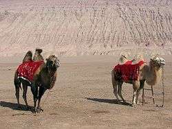
The main livestock of the region have traditionally been sheep. Much of the region's pasture land is in its northern part, where more precipitation is available,[115] but there are mountain pastures throughout the region.
Due to the lack of access to the ocean and limited amount of inland water, Xinjiang's fish resources are somewhat limited. Nonetheless, there is a significant amount of fishing in Lake Ulungur and Lake Bosten and in the Irtysh River. A large number of fish ponds have been constructed since the 1970s, their total surface exceeding 10,000 hectares by the 1990s. In 2000, the total of 58,835 tons of fish was produced in Xinjiang, 85% of which came from aquaculture.[116]
In the past, the Lop Lake was known for its fisheries and the area residents, for their fishing culture; now, due to the diversion of the waters of the Tarim River, the lake has dried out.
Mining and minerals
Xinjiang was known for producing salt, soda, borax, gold, jade in the 19th century.[117]
The oil and gas extraction industry in Aksu and Karamay is growing, with the West–East Gas Pipeline linking to Shanghai. The oil and petrochemical sector get up to 60 percent of Xinjiang's economy.[118] Containing over a fifth of China's coal, natural gas and oil resources, Xinjiang has the highest concentration of fossil fuel reserves of any region in the country.[119]
Foreign trade
Xinjiang's exports amounted to US$19.3 billion, while imports turned out to be US$2.9 billion in 2008. Most of the overall import/export volume in Xinjiang was directed to and from Kazakhstan through Ala Pass. China's first border free trade zone (Horgos Free Trade Zone) was located at the Xinjiang-Kazakhstan border city of Horgos.[120] Horgos is the largest "land port" in China's western region and it has easy access to the Central Asian market. Xinjiang also opened its second border trade market to Kazakhstan in March 2006, the Jeminay Border Trade Zone.[121]
Economic and Technological Development Zones
- Bole Border Economic Cooperation Area[122]
- Shihezi Border Economic Cooperation Area[123]
- Tacheng Border Economic Cooperation Area[124]
- Ürümqi Economic & Technological Development Zone is northwest of Ürümqi. It was approved in 1994 by the State Council as a national level economic and technological development zones. It is 1.5 km (0.93 mi) from the Ürümqi International Airport, 2 km (1.2 mi) from the North Railway Station and 10 km (6.2 mi) from the city center. Wu Chang Expressway and 312 National Road passes through the zone. The development has unique resources and geographical advantages. Xinjiang's vast land, rich in resources, borders eight countries. As the leading economic zone, it brings together the resources of Xinjiang's industrial development, capital, technology, information, personnel and other factors of production.[125]
- Ürümqi Export Processing Zone is in Urumuqi Economic and Technology Development Zone. It was established in 2007 as a state-level export processing zone.[126]
- Ürümqi New & Hi-Tech Industrial Development Zone was established in 1992 and it is the only high-tech development zone in Xinjiang, China. There are more than 3470 enterprises in the zone, of which 23 are Fortune 500 companies. It has a planned area of 9.8 km2 (3.8 sq mi) and it is divided into four zones. There are plans to expand the zone.[127]
- Yining Border Economic Cooperation Area[128]
Culture
Demographics
| Historical population | ||
|---|---|---|
| Year | Pop. | ±% |
| 1912[129] | 2,098,000 | — |
| 1928[130] | 2,552,000 | +21.6% |
| 1936–37[131] | 4,360,000 | +70.8% |
| 1947[132] | 4,047,000 | −7.2% |
| 1954[133] | 4,873,608 | +20.4% |
| 1964[134] | 7,270,067 | +49.2% |
| 1982[135] | 13,081,681 | +79.9% |
| 1990[136] | 15,155,778 | +15.9% |
| 2000[137] | 18,459,511 | +21.8% |
| 2010[138] | 21,813,334 | +18.2% |
The earliest Tarim mummies, dated to 1800 BC, are of a Caucasoid physical type.[139] East Asian migrants arrived in the eastern portions of the Tarim Basin about 3000 years ago, ans the Uyghur peoples appeared after the collapse of the Orkon Uyghur Kingdom, based in modern-day Mongolia, around 842 AD.[140][141]
The Islamization of Xinjiang started around 1000 AD by eliminating Buddhism.[142] Xinjiang Muslim Turkic peoples contain Uyghurs, Kazaks, Kyrgyz, Tatars, Uzbeks; Muslim Iranian peoples comprise Tajiks, Sarikolis/Wakhis (often conflated as Tajiks); Muslim Sino-Tibetan peoples are such as the Hui. Other ethnic groups in the region are Hans, Mongols (Oirats, Daurs, Dongxiangs), Russians, Xibes, Manchus. Around 70,000 Russian immigrants were living in Xinjiang in 1945.[143]
The Han Chinese of Xinjiang arrived at different times from different directions and social backgrounds. There are now descendants of criminals and officials who had been exiled from China proper during the second half of the 18th and the first half of the 19th centuries; descendants of families of military and civil officers from Hunan, Yunnan, Gansu and Manchuria; descendants of merchants from Shanxi, Tianjin, Hubei, and Hunan; and descendants of peasants who started immigrating into the region in 1776.[144]
Some Uyghur scholars claim descent from both the Turkic Uyghurs and the pre-Turkic Tocharians (or Tokharians, whose language was Indo-European); also, Uyghurs often have relatively-fair skin, hair, and eyes and other Caucasoid physical traits.
In 2002, there were 9,632,600 males (growth rate of 1.0%) and 9,419,300 females (growth rate of 2.2%). The population overall growth rate was 1.09%, with 1.63% of birth rate and 0.54% mortality rate.
The Qing began a process of settling Han, Hui, and Uyghur settlers into Northern Xinjiang (Dzungaria) in the 18th century. At the start of the 19th century, 40 years after the Qing reconquest, there were around 155,000 Han and Hui Chinese in northern Xinjiang and somewhat more than twice that number of Uyghurs in southern Xinjiang.[145] A census of Xinjiang under Qing rule in the early 19th century tabulated ethnic shares of the population as 30% Han and 60% Turkic, and it dramatically shifted to 6% Han and 75% Uyghur in the 1953 census. However, a situation similar to the Qing era's demographics with a large number of Han had been restored by 2000, with 40.57% Han and 45.21% Uyghur.[146] Professor Stanley W. Toops noted that today's demographic situation is similar to that of the early Qing period in Xinjiang.[147] Before 1831, only a few hundred Chinese merchants lived in Southern Xinjiang oases (Tarim Basin), and only a few Uyghurs lived in Northern Xinjiang (Dzungaria).[148] After 1831, the Qing encouraged Han Chinese migration into the Tarim Basin, in southern Xinjiang, but with very little success, and permanent troops were stationed on the land there as well.[149] Political killings and expulsions of non-Uyghur populations during the uprisings in the 1860s[149] and the 1930s saw them experience a sharp decline as a percentage of the total population[150] though they rose once again in the periods of stability from 1880, which saw Xinjiang increase its population from 1.2 million[151][152], to 1949. From a low of 7% in 1953, the Han began to return to Xinjiang between then and 1964, where they comprised 33% of the population (54% Uyghur), like in Qing times. A decade later, at the beginning of the Chinese economic reform in 1978, the demographic balance was 46% Uyghur and 40% Han,[146] which has not did not change drastically until the last census, in 2000, when the Uyghur population had reduced to 42%.[153] Military personnel are not counted and national minorities are undercounted in the Chinese census, as in most other censuses.[154] While some of the shift has been attributed to an increased Han presence,[9] Uyghurs have also emigrated to other parts of China, where their numbers have increased steadily. Uyghur independence activists express concern over the Han population changing the Uyghur character of the region though the Han and Hui Chinese mostly live in Northern Xinjiang Dzungaria and are separated from areas of historic Uyghur dominance south of the Tian Shan mountains (Southwestern Xinjiang), where Uyghurs account for about 90% of the population.[155]
In general, Uyghurs are the majority in Southwestern Xinjiang, including the prefectures of Kashgar, Khotan, Kizilsu and Aksu (about 80% of Xinjiang's Uyghurs live in those four prefectures) as well as Turpan Prefecture, in Eastern Xinjiang. The Han are the majority in Eastern and Northern Xinjiang (Dzungaria), including the cities of Ürümqi, Karamay, Shihezi and the prefectures of Changjyi, Bortala, Bayin'gholin, Ili (especially the cities of Kuitun) and Kumul. Kazakhs are mostly concentrated in Ili Prefecture in Northern Xinjiang. Kazakhs are the majority in the northernmost part of Xinjiang.
| Ethnic groups in Xinjiang 根据2015年底人口抽查统计 [156] | ||
|---|---|---|
| Nationality | Population | Percentage |
| Uyghur | 11,303,300 | 46.42% |
| Han | 8,611,000 | 38.99% |
| Kazakh | 1,591,200 | 7.02% |
| Hui | 1,015,800 | 4.54% |
| Kirghiz | 202,200 | 0.88% |
| Mongols | 180,600 | 0.83% |
| Tajiks | 50,100 | 0.21% |
| Xibe | 43,200 | 0.20% |
| Manchu | 27,515 | 0.11% |
| Tujia | 15,787 | 0.086% |
| Uzbek | 18,769 | 0.066% |
| Russian | 11,800 | 0.048% |
| Miao | 7,006 | 0.038% |
| Tibetan | 6,153 | 0.033% |
| Zhuang | 5,642 | 0.031% |
| Tatar | 5,183 | 0.024% |
| Salar | 3,762 | 0.020% |
| Other | 129,190 | 0.600% |
| Major ethnic groups in Xinjiang by region (2000 census)[upper-roman 1] P = Prefecture; AP = Autonomous prefecture; PLC = Prefecture-level city; DACLC = Directly administered county-level city.[157] | ||||
|---|---|---|---|---|
| Uyghurs (%) | Han (%) | Kazakhs (%) | others (%) | |
| Xinjiang | 43.6 | 40.6 | 8.3 | 7.5 |
| Ürümqi PLC | 11.8 | 75.3 | 3.3 | 9.6 |
| Karamay PLC | 13.8 | 78.1 | 3.7 | 4.5 |
| Turpan Prefecture | 70.0 | 23.3 | < 0.1 | 6.6 |
| Kumul Prefecture | 18.4 | 68.9 | 8.8 | 3.9 |
| Changji AP + Wujiaqu DACLC | 3.9 | 75.1 | 8.0 | 13.0 |
| Bortala AP | 12.5 | 67.2 | 9.1 | 11.1 |
| Bayin'gholin AP | 32.7 | 57.5 | < 0.1 | 9.7 |
| Aksu Prefecture + Aral DACLC | 71.8 | 26.6 | 0.1 | 1.4 |
| Kizilsu AP | 64.0 | 6.4 | < 0.1 | 29.6 |
| Kashgar Prefecture + Tumushuke DACLC | 89.3 | 9.2 | < 0.1 | 1.5 |
| Khotan Prefecture | 96.4 | 3.3 | < 0.1 | 0.2 |
| Ili AP[note 2] | 16.1 | 44.4 | 25.6 | 13.9 |
| – Kuitun DACLC | 0.5 | 94.6 | 1.8 | 3.1 |
| – former Ili Prefecture | 27.2 | 32.4 | 22.6 | 17.8 |
| – Tacheng Prefecture | 4.1 | 58.6 | 24.2 | 13.1 |
| – Altay Prefecture | 1.8 | 40.9 | 51.4 | 5.9 |
| Shihezi DACLC | 1.2 | 94.5 | 0.6 | 3.7 |
- Does not include members of the People's Liberation Army in active service.
Vital statistics
| Year[158] | Population | Live births | Deaths | Natural change | Crude birth rate (per 1000) |
Crude death rate (per 1000) |
Natural change (per 1000) |
|---|---|---|---|---|---|---|---|
| 2011 | 22,090,000 | 14.99 | 4.42 | 10.57 | |||
| 2012 | 22,330,000 | 15.32 | 4.48 | 10.84 | |||
| 2013 | 22,640,000 | 15.84 | 4.92 | 10.92 | |||
| 2014 | 22,980,000 | 16.44 | 4.97 | 11.47 | |||
| 2015 | 23,600,000 | 15.59 | 4.51 | 11.08 | |||
| 2016 | 23,980,000 | 15.34 | 4.26 | 11.08 | |||
| 2017 | 24,450,000 | 15.88 | 4.48 | 11.40 | |||
| 2018 | 24,870,000 | 10.69 | 4.56 | 6.13 |
Religion
Religion in Xinjiang (around 2010)
The major religions in Xinjiang are Islam among the Uyghurs and the Hui Chinese minority, and many of the Han Chinese practice Chinese folk religions, Confucianism, Taoism and Buddhism. According to a demographic analysis of the year 2010, Muslims form 58% of the province's population.[159] In 1950, there were 29,000 mosques and 54,000 imams in Xinjiang, which fell to 14,000 mosques and 29,000 imams by 1966. Following the Cultural Revolution, there were only about 1,400 remaining mosques. By the mid-1980's, the number of mosques had returned to 1950 levels.[161] Christianity in Xinjiang is the religion of 1% of the population according to the Chinese General Social Survey of 2009.[160]
A majority of the Uyghur Muslims adhere to Sunni Islam of the Hanafi school of jurisprudence or madhab. A minority of Shias, almost exclusively of the Nizari Ismaili (Seveners) rites are located in the higher mountains of Tajik and Tian Shan. In the western mountains (the Tajiks), almost the entire population of Tajiks (Sarikolis and Wakhis), are Nizari Ismaili Shia.[9] In the north, in the Tian Shan, the Kazakhs and Kyrgyz are Sunni.
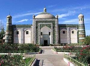
Afaq Khoja Mausoleum and Id Kah Mosque in Kashgar are most important Islamic Xinjiang sites. Emin Minaret in Turfan is a key Islamic site. Bezeklik Thousand Buddha Caves is a noticeable Buddhist site.
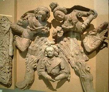 "Heroic Gesture of the Bodhisattva", example of 6th-7th-century terracotta Greco-Buddhist art (local populations were Buddhist) from Tumxuk, Xinjiang
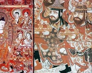 Sogdian donors to the Buddha, 8th century fresco (with detail), Bezeklik, Eastern Tarim Basin
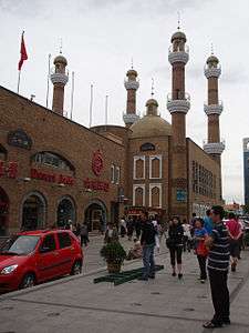 A mosque in Ürümqi
.jpg) Temple of the Great Buddha in Midong, Ürümqi
Temple of the Great Buddha in Midong, Ürümqi_Taoist_Temple_at_Tianchi_(Heavenly_Lake)_in_Fukang%2C_Changji%2C_Xinjiang.jpg) Taoist Temple of Fortune and Longevity at the Heavenly Lake of Tianshan in Fukang, Changji Hui Autonomous Prefecture
Taoist Temple of Fortune and Longevity at the Heavenly Lake of Tianshan in Fukang, Changji Hui Autonomous Prefecture.jpg)
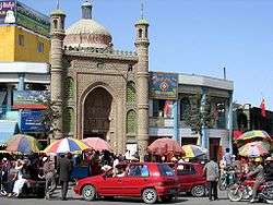
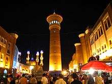
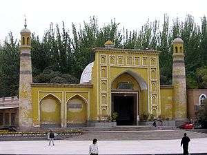 Id Kah mosque in Kashgar, largest mosque in China
Media
The Xinjiang Networking Transmission Limited operates the Urumqi People Broadcasting Station and the Xinjiang People Broadcasting Station, broadcasting in Mandarin, Uyghur, Kazakh and Mongolian.
In 1995, there were 50 minority-language newspapers published in Xinjiang, including the Qapqal News, the world's only Xibe language newspaper.[162] The Xinjiang Economic Daily is considered one of China's most dynamic newspapers.[163]
For a time after the July 2009 riots, authorities placed restrictions on the internet and text messaging, gradually permitting access to state-controlled websites like Xinhua's,[164] until restoring Internet to the same level as the rest of China on 14 May 2010.[165][166][167]
As reported by the BBC News, "China strictly controls media access to Xinjiang so reports are difficult to verify."[168]
Sports
Xinjiang is home to the Xinjiang Guanghui Flying Tigers professional basketball team of the Chinese Basketball Association, and to Xinjiang Tianshan Leopard F.C., a football team that plays in China League One.
The capital, Ürümqi, is home to the Xinjiang University baseball team, an integrated Uyghur and Han group profiled in the documentary film Diamond in the Dunes.
Transportation
Roads
In 2008, according to the Xinjiang Transportation Network Plan, the government has focused construction on State Road 314, Alar-Hotan Desert Highway, State Road 218, Qingshui River Line-Yining Highway, and State Road 217, as well as other roads.
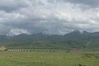
The construction of the first expressway in the mountainous area of Xinjiang began a new stage in its construction on 24 July 2007. The 56 km (35 mi) highway linking Sayram Lake and Guozi Valley in Northern Xinjiang area had cost 2.39 billion yuan. The expressway is designed to improve the speed of national highway 312 in northern Xinjiang. The project started in August 2006 and several stages have been fully operational since March 2007. Over 3,000 construction workers have been involved. The 700 m-long Guozi Valley Cable Bridge over the expressway is now currently being constructed, with the 24 main pile foundations already completed. Highway 312 national highway Xinjiang section, connects Xinjiang with China's east coast, Central and West Asia, plus some parts of Europe. It is a key factor in Xinjiang's economic development. The population it covers is around 40% of the overall in Xinjiang, who contribute half of the GDP in the area.
The head of the Transport Department was quoted as saying that 24,800,000,000 RMB had been invested into Xinjiang's road network in 2010 alone and, by this time, the roads covered approximately 152,000 km (94,000 mi).[169]
Rail
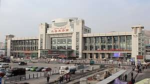

Xinjiang's rail hub is Ürümqi. To the east, a conventional and a high-speed rail line runs through Turpan and Hami to Lanzhou in Gansu Province. A third outlet to the east connects Hami and Inner Mongolia.
To the west, the Northern Xinjiang runs along the northern footslopes of the Tian Shan range through Changji, Shihezi, Kuytun and Jinghe to the Kazakh border at Alashankou, where it links up with the Turkestan-Siberia Railway. Together, the Northern Xinjiang and the Lanzhou-Xinjiang lines form part of the Trans-Eurasian Continental Railway, which extends from Rotterdam, on the North Sea, to Lianyungang, on the East China Sea. The Second Ürümqi-Jinghe Railway provides additional rail transport capacity to Jinghe, from which the Jinghe-Yining-Horgos Railway heads into the Ili River Valley to Yining, Huocheng, and Khorgos, a second rail border crossing with Kazakhstan. The Kuytun-Beitun Railway runs from Kuytun north into the Junggar Basin to Karamay and Beitun, near Altay.
In the south, the Southern Xinjiang Line from Turpan runs southwest along the southern footslopes of the Tian Shan into the Tarim Basin, with stops at Yanqi, Korla, Kuqa, Aksu, Maralbexi (Bachu), Artux, and Kashgar. From Kashgar, the Kashgar-Hotan Railway, follows the southern rim of the Tarim to Hotan, with stops at Shule, Akto, Yengisar, Shache (Yarkant), Yecheng (Karghilik), Moyu (Karakax).
The Ürümqi-Dzungaria Railway connects Ürümqi with coal fields in the eastern Junggar Basin. The Hami–Lop Nur Railway connects Hami with potassium salt mines in and around Lop Nur.
The Golmud-Korla Railway, under construction as of August 2016, would provide an outlet to Qinghai. Railways to Pakistan and Kyrgyzstan have been proposed.
East Turkestan independence movement
Some factions in Xinjiang province advocate establishing an independent country, which has caused tension and ethnic strife in the Xinjiang province.[170][171] The Xinjiang conflict[172] is an ongoing[173] separatist conflict in the northwestern part of China. The separatist movement claims that the region, which they view as their homeland and refer to as "East Turkestan", is not part of China, but was invaded by China in 1949 and has been under Chinese occupation since then. China asserts that the region has been part of China since ancient times.[174] The separatist movement is led by ethnically Uyghur Muslim underground organizations, most notably the East Turkestan independence movement, against the Chinese government. According to the Asia-Pacific Center for Security Studies, the two main sources for separatism in the Xinjiang Province are religion and ethnicity. Religiously, the Uyghur peoples of Xinjiang follow Islam, while in the large cities of Han China, the primary religions practiced are Buddhism, Confucianism, Taoism or a combination of them. The other major difference and source of friction with eastern China is ethnicity. The Uyghurs are ethnically, linguistically, and culturally Turkic, a clear distinction from the Han and other ethnicities that are the majority in the eastern regions of China. Hence, there is a noticeable voice of ethnic Uyghurs who would like to separate their region from China. Ironically, the capital of Xinjiang, Ürümqi, was originally a Han and Hui (Tungan) city with few Uyghur people before recent Uyghur migration to the city.[175] In retaliation against separatists, China has engaged in "strike hard" campaigns since 1996.[176] On 5 June 2014, China sentenced nine persons to death for terrorist attacks. They were seeking to overthrow Chinese rule in Xinjiang, and re-establish an independent Uyghur state of East Turkestan.[177]
See also
- Xinjiang under Qing rule
- Islamization and Turkification of Xinjiang
- Soviet invasion of Xinjiang
- Tajiks of Xinjiang
- Xinjiang Production and Construction Corps
- Affirmative action in China
- Xinjiang re-education camps
- Administrative divisions of China
- Autonomous regions of China
- China Cotton Association
- East Turkestan
- East Turkestan independence movement
- List of universities and colleges in Xinjiang
- Western Regions
- Xinjiang coins
- Xinjiang conflict
- Xinjiang cuisine
- Xinjiang Wars
Notes
- The imperial-era Chinese word gui 歸 is not descriptive, but normative: It is a term which seeks to justify new conquests by presenting them as a naturally appropriate "return." It does not indicate that the territory already had been conquered earlier. Thus, the term "Xinjiang" was also used in many other places newly conquered, but never were ruled by Chinese empires before, including in what is now Southern China.[18]
- Ili Kazakh Autonomous Prefecture is composed of Kuitun DACLC, Tacheng Prefecture, Aletai Prefecture, and the former Ili Prefecture. Ili Prefecture has been disbanded and its former area is now directly administered by Ili AP.
References
Citations
- 6-1 自然资源划 [6-1 Natural Resources] (in Chinese). Statistics Bureau of Xinjiang. Archived from the original on 22 December 2015. Retrieved 19 December 2015.
- Mackerras, Colin; Yorke, Amanda (1991). The Cambridge handbook of contemporary China. Cambridge University Press. p. 192. ISBN 978-0-521-38755-2. Retrieved 4 June 2008.
- Susan M. Walcott; Corey Johnson (1 November 2013). "Where Inner Asia Meets Outer China: The Xinjiang Uyghur Autonomous Region of China". Eurasian Corridors of Interconnection: From the South China to the Caspian Sea. Routledge. pp. 64–65.
- "National Data". Archived from the original on 15 April 2020. Retrieved 10 April 2020.
- "China". Ethnologue. Archived from the original on 26 December 2018. Retrieved 3 June 2015.
- 新疆维吾尔自治区2017年国民经济和社会发展统计公报 [Statistical Communiqué of Xinjiang on the 2017 National Economic and Social Development] (in Chinese). Statistical Bureau of Xinjiang. 25 April 2018. Archived from the original on 22 June 2018. Retrieved 22 June 2018.
- United Nations Development Program (2013). China Human Development Report 2013: Sustainable and Liveable Cities: Toward Ecological Urbanisation (PDF). Beijing: Translation and Publishing Corporation. ISBN 978-7-5001-3754-2. Archived (PDF) from the original on June 11, 2014. Retrieved May 14, 2014.
- "______". The Government of Xinjiang Uygur Autonomous Region of China. Archived from the original on December 1, 2017. Retrieved August 19, 2018.
- "Regions and territories: Xinjiang". BBC News. 7 May 2011. Archived from the original on 20 May 2011.
- "Turkestan". Catholic Encyclopedia. XV. New York: Robert Appleton Company. 1912. Archived from the original on April 20, 2008. Retrieved November 26, 2008.
- 新疆绿洲面积已从4.3%增至9.7%. 人民网 (in Chinese). Archived from the original on 11 October 2017. Retrieved 27 May 2017.
- Tiezzi, Shannonb (October 3, 2015). "China's 'Protracted War' in Xinjiang". The Diplomat. Archived from the original on October 24, 2016. Retrieved October 29, 2016.
- "East Turkestan: Chinese Authorities Confiscate Passports Amid Security Crackdown". Unrepresented Nations and Peoples Organization (UNPO). October 21, 2016. Archived from the original on October 30, 2016. Retrieved October 29, 2016.
- Tyler (2004), p. 3.
- Hill (2009), pp. xviii, 60.
- Whitfield, Susan (2004). The Silk Road: trade, travel, war and faith. Serindia Publications. p. 27.
- "Introduction". The Lost Frontier Treaty Maps that Changed Qing's Northwestern Boundaries. Archived from the original on 29 January 2020. Retrieved 29 January 2020.
The Qianlong emperor (1736-1796) named the region Xinjiang, for New Territory.
- Weinstein (2013), p. 4
- "Cultivating and Guarding the West Regions: the Establishment of Xinjiang Province" (in Chinese). China Central Television. December 6, 2004. Archived from the original on November 9, 2011. Retrieved August 27, 2009.
- Bovingdon (2010), p. 199.
- Liu & Faure (1996), p. 69.
- Liu & Faure (1996), p. 70.
- Liu & Faure (1996), p. 67.
- Liu & Faure (1996), p. 77.
- Liu & Faure (1996), p. 78.
- "The Dead Tell a Tale China Doesn't Care to Listen To". The New York Times. 18 November 2008. Archived from the original on 12 June 2018. Retrieved 11 April 2020.
- Coonan, Clifford (28 August 2006). "A meeting of civilisations: The mystery of China's celtic mummies". Independent. Archived from the original on 4 January 2016. Retrieved 3 January 2020.
- Chunxiang Li; Hongjie Li; Yinqiu Cui; Chengzhi Xie; Dawei Cai; Wenying Li; Victor H Mair; Zhi Xu; Quanchao Zhang; Idelis Abuduresule; Li Jin; Hong Zhu; Hui Zhou (2010). "Evidence that a West-East admixed population lived in the Tarim Basin as early as the early Bronze Age". BMC Biology. 8 (15): 15. doi:10.1186/1741-7007-8-15. PMC 2838831. PMID 20163704.
- Tremblay, Xavier (2007). "The Spread of Buddhism in Serindia: Buddhism Among Iranians, Tocharians and Turks before the 13th Century". In Ann Heirman & Stephan Peter Bumbacker (eds.). The Spread of Buddhism. Leiden & Boston: Koninklijke Brill. p. 77. ISBN 978-90-04-15830-6.
- Iaroslav Lebedynsky, Les Saces, ISBN 2-87772-337-2, p. 59.
- Dillon, Michael (1998). China: A Historical and Cultural Dictionary. Psychology Press. ISBN 978-0-7007-0439-2.
- Liu (2001), pp. 267–268
- C. Michael Hogan (2007). "Silk Road, North China". The Megalithic Portal. Archived from the original on 2 October 2013. Retrieved 26 November 2008.
- Ebrey, Patricia Buckley (2010). The Cambridge Illustrated History of China. Cambridge University Press. p. 111. ISBN 978-0-521-12433-1.
- Twitchett, Denis; Wechsler, Howard J. (1979). "Kao-tsung (reign 649-83) and the Empress Wu: The Inheritor and the Usurper". In Denis Twitchett; John Fairbank (eds.). The Cambridge History of China, Volume 3: Sui and T'ang China Part I. Cambridge University Press. p. 228. ISBN 978-0-521-21446-9.
- Skaff, Jonathan Karem (2009). Nicola Di Cosmo (ed.). Military Culture in Imperial China. Harvard University Press. pp. 183–185. ISBN 978-0-674-03109-8.
- Soucek, Svatopluk (2000). "Chapter 5 – The Qarakhanids". A history of Inner Asia. Cambridge University Press. ISBN 978-0-521-65704-4.
- The Empire of the Qara Khitai in Eurasian History: Between China and the Islamic World, pp. 94
- Millward (2007), p. 15.
- Millward (2007), p. 16.
- Millward (2007), p. 55.
- Hamilton Alexander Rosskeen Gibb; Bernard Lewis; Johannes Hendrik Kramers; Charles Pellat; Joseph Schacht (1998). The Encyclopaedia of Islam. Brill. p. 677. Archived from the original on 1 January 2016. Retrieved 10 July 2015.
- Millward (2007), p. 98.
- Wei Yuan, 聖武記 Sheng Wu Ji, vol. 4.
- Chu, Wen-Djang (1966). The Moslem Rebellion in Northwest China 1862–1878. Mouton & co.. p. 1.
- Tyler (2004), p. 55.
- Millward (2007), p. 113.
- Martin (1847), p. 21.
- Millward (1998), p. 124.
- Millward (2007), p. 108.
- Millward (2007), p. 109.
- Millward (1998), pp. 206–207.
- Ildikó Bellér-Hann, "Situating the Uyghurs Between China and Central Asia"; Ashgate Publishing, Ltd., 2007; p.39
- Mesny (1905), p. 5.
- Tyler (2004), p. 61.
- 从 斌静案 看清代驻疆官员与新疆的稳定 [Viewing the Stability of Xinjiang Officials and Xinjiang in the Case of Bin Jing] (in Chinese). Archived from the original on 20 April 2016. Retrieved 16 April 2011.
- Millward (2007), p. 151.
- Falkenheim, Victor C.; Hsieh, Chiao-Min (9 August 2018) [Online article added 26 July 1999]. "Xinjiang: autonomous region, China". Encyclopædia Britannica. Archived from the original on 14 August 2018. Retrieved 19 August 2018.
- R. Michael Feener, "Islam in World Cultures: Comparative Perspectives", ABC-CLIO, 2004, ISBN 1-57607-516-8
- "Uighurs and China's Xinjiang Region". cfr.org. Archived from the original on 13 September 2018. Retrieved 13 October 2018.
- Millward (2007), p. 24.
- Jeremy Brown; Paul Pickowicz, eds. (2010). Dilemmas of Victory. Harvard University Press. p. 186. ISBN 978-0-6740-4702-0.
- Amy Goodman (8 July 2009). "Uyghur Protests Widen as Xinjiang Unrest Flares". Axis of Logic. Archived from the original on 7 July 2011. Retrieved 20 July 2009.
- Bovingdon (2010), pp. 43–46.
- Hopper & Webber (2009), p. 176.
- Guo & Guo (2007), p. 220.
- Guo & Hickey (2009), p. 164.
- Howell (2009), p. 37.
- Tiziano Terzani (1985). The Forbidden Door. Asia 2000 Ltd. p. 224-225 – via Internet Archive.
- Hopper & Webber (2009), pp. 173–175.
- Hopper & Webber (2009), pp. 178–179.
- Hopper & Webber (2009), p. 184.
- Hopper & Webber (2009), pp. 187–188.
- Bovingdon (2010), p. 11.
- Rudelson, Justin Ben-Adam (16 February 2000). "Uyghur "separatism": China's policies in Xinjiang fuel dissent". Central Asia-Caucasus Institute Analyst. Archived from the original on 29 February 2012. Retrieved 29 January 2010.
- Gunaratna, Rohan; Pereire, Kenneth George (2006). "An al-Qaeda associate group operating in China?" (PDF). China and Eurasia Forum Quarterly. 4 (2): 59. Archived from the original (PDF) on 6 January 2011.
Since the Ghulja Incident, numerous attacks including attacks on buses, clashes between ETIM militants and Chinese security forces, assassination attempts, attempts to attack Chinese key installations and government buildings have taken place, though many cases go unreported.
- "Chinese police destroy terrorist camp in Xinjiang, one policeman killed". CCTV International. 1 October 2007. Archived from the original on 3 January 2009. Retrieved 26 November 2008.
- Elizabeth Van Wie Davis, "China confronts its Uyghur threat Archived 12 May 2008 at the Wayback Machine," Asia Times Online, 18 April 2008.
- Jacobs, Andrew (5 August 2008). "Ambush in China Raises Concerns as Olympics Near". The New York Times. Archived from the original on 10 April 2009. Retrieved 27 March 2010.
- "Waterhouse Caulfield Cup breakthrough". Archived from the original on 4 October 2009. Retrieved 7 July 2009.
- "VI. Progress in Education, Science and Technology, Culture and Health Work". History and Development of Xinjiang. State Council of the People's Republic of China. 26 May 2003. Archived from the original on 29 January 2011. Retrieved 31 December 2010.
- "中国统计年鉴—2018". Archived from the original on 6 January 2019. Retrieved 28 January 2019.
- Ministry of Civil Affairs. 2014年12月中华人民共和国县以上行政区划代码 [Administrative code of the county or above in the People's Republic of China in December 2014] (in Chinese). Archived from the original on 2 April 2015. Retrieved 12 December 2015.
- Shenzhen Bureau of Statistics. 深圳统计年鉴2014 [Shenzhen Statistical Yearbook 2014] (in Chinese). China Statistics Print. Archived from the original on 12 May 2015. Retrieved 29 May 2015.
- 国务院人口普查办公室 [Department of Population Census of the State Council]; 国家统计局人口和就业统计司编 [Department of Population and Employment Statistics, National Bureau of Statistics] (2012). 中国2010年人口普查分乡, 镇, 街道资料 [China 2010 Census by Country, Town, Street Information] (in Chinese). Beijing: Z Hongguo Statistics Press. ISBN 978-7-5037-6660-2. OCLC 992517929.
- Ministry of Civil Affairs (August 2014). 中国民政统计年鉴2014 [China Civil Affairs Statistics Yearbook 2014] (in Chinese). China Statistics Print. ISBN 978-7-5037-7130-9.
- 国务院人口普查办公室 [Department of Population Census of the State Council]; 国家统计局人口和社会科技统计司编 [Department of Population and Social Science and Statistics, National Bureau of Statistics] (2012). 中国2010年人口普查分县资料. Beijing: China Statistics Print. ISBN 978-7-5037-6659-6.
- "DCP: Geographic Center of Asia (visit #1)". www.confluence.org. Archived from the original on 2 June 2016. Retrieved 13 October 2013.
- "The Working-Calendar for The Xinjiang Uygur Autonomous Region Government". Archived from the original on 4 December 2011.
- Han, Enze (2010). "Boundaries, Discrimination, and Interethnic Conflict in Xinjiang, China". International Journal of Conflict and Violence. 4 (2): 251. Archived from the original on 19 October 2014. Retrieved 14 December 2012.
- Demick, Barbara (31 March 2009). "Clocks square off in China's far west". Archived from the original on 17 December 2012. Retrieved 14 December 2012 – via LA Times.
- 吐鲁番 – 气象数据 – 中国天气网. www.weather.com.cn. Archived from the original on 14 October 2013. Retrieved 30 June 2012.
- Gorbunov, A.P. (1993), "Geocryology in Mt. Tianshan", PERMAFROST: Sixth International Conference. Proceedings. July 5–9, Beijing, China, 2, South China University of Technology Press, pp. 1105–1107, ISBN 978-7-5623-0484-5
- "China Promises Unfulfilled, An Assessment of China's National Human Rights Action Plan" (PDF). Human Rights Watch. 2011. Archived (PDF) from the original on 11 October 2017. Retrieved 4 December 2016.
- "China 'holding at least 120,000 Uighurs in re-education camps'". The Guardian. 25 January 2018. Archived from the original on 19 August 2018. Retrieved 4 August 2018.
- "Former inmates of China's Muslim 'reeducation' camps tell of brainwashing, torture". The Washington Post. 16 May 2018. Archived from the original on 21 September 2018. Retrieved 4 August 2018.
- "China: Free Xinjiang 'Political Education' Detainees". Human Rights Watch. Archived from the original on 25 October 2018. Retrieved 5 August 2018.
- Ramzy, Austin; Buckley, Chris (16 November 2019). "'Absolutely No Mercy': Leaked Files Expose How China Organized Mass Detentions of Muslims". The New York Times. ISSN 0362-4331. Archived from the original on 22 December 2019. Retrieved 16 November 2019.
- Kate O’Keeffe and Katy Stech Ferek (14 November 2019). "Stop Calling China's Xi Jinping 'President,' U.S. Panel Says". The Wall Street Journal. Archived from the original on 15 November 2019. Retrieved 27 November 2019.
- Sudworth, John (24 October 2018). "China's hidden camps". BBC News. Archived from the original on 5 January 2019. Retrieved 17 February 2019.
- Movius, Lisa. "'Hundreds' of cultural figures caught up in China's Uyghur persecution". The Art Newspaper. Archived from the original on 2 January 2019. Retrieved 3 January 2019.
- "37 countries rally around China at top UN human rights body". Associated Press. 12 July 2019. Archived from the original on 13 July 2019. Retrieved 18 July 2019.
- "Which Countries Are For or Against China's Xinjiang Policies?". The Diplomat. 15 July 2019. Archived from the original on 16 July 2019. Retrieved 18 July 2019.
- "Qatar refuses to certify China's human rights record on treatment of Uighur Muslims". The Print. Archived from the original on 11 February 2020. Retrieved 30 November 2019.
- Yellinek, Roie; Chen, Elizabeth (31 December 2019). "The "22 vs. 50" Diplomatic Split Between the West and China Over Xinjiang and Human Rights". China Brief. Vol. 19 no. 22. Jamestown Foundation. Archived from the original on 7 May 2020. Retrieved 8 May 2020.
- "Bulletin for the economy and society development in 2015". Retrieved 6 May 2010.
- "Xinjiang Province: Economic News and Statistics for Xinjiang's Economy". Archived from the original on 8 October 2011. Retrieved 22 October 2011.
- Millward (2007), p. 305.
- "Efforts to boost 'leapfrog development' in Xinjiang". China Daily / Xinhua. July 5, 2010. Archived from the original on July 23, 2010. Retrieved July 14, 2010.
- 12–13 主要年份农作物播种面积 [12–13 Sown Area of Crops in Major Years] (in Chinese). Statistics Bureau of Xinjiang. Archived from the original on 2 January 2018. Retrieved 2 January 2018.
- 新疆维吾尔自治区2016年国民经济和社会发展统计公报 [Statistical Communique of 2016 National Economic and Social Development of Xinjiang Uygur Autonomous Region] (in Chinese). Xinjiang Uygur Autonomous Region People's Government. 17 April 2017. Archived from the original on 9 June 2017. Retrieved 17 April 2017.
- Bellér-Hann (2008), pp. 112–113.
- Bellér-Hann (2008), p. 152.
- Caster, Michael (27 October 2019). "It's time to boycott any company doing business in Xinjiang". The Guardian. ISSN 0261-3077. Archived from the original on 27 November 2019. Retrieved 27 November 2019.
- Bellér-Hann (2008), p. 37.
- Guo Yan, Fisheries Development in Xinjiang, China Archived 8 October 2013 at the Wayback Machine
- Mesny (1899), p. 386.
- Alain Charles (2005). The China Business Handbook (8th ed.). ISBN 978-0-9512512-8-7.
- Jinhui Duan; Shuying Wei; Ming Zeng; Yanfang Ju (1 January 2016). "The Energy Industry in Xinjiang, China: Potential, Problems, and Solutions". Power Mag. Archived from the original on 2 July 2016. Retrieved 4 July 2016.
- "Work on free trade zone on the agenda". People's Daily Online. 2 November 2004. Archived from the original on 29 September 2008. Retrieved 26 November 2008.
- "Xinjiang to open 2nd border trade market to Kazakhstan". Xinhua. 12 December 2006. Archived from the original on 7 January 2009. Retrieved 26 November 2008.
- "RightSite.asia – Bole Border Economic Cooperation Area". Archived from the original on 26 August 2011. Retrieved 22 July 2010.
- "RightSite.asia – Shihezi Border Economic Cooperation Area". Archived from the original on 9 May 2012. Retrieved 22 July 2010.
- "RightSite.asia – Tacheng Border Economic Cooperation Area". Archived from the original on 9 May 2012. Retrieved 22 July 2010.
- "RightSite.asia | Ürümqi Economic & Technological Development Zone". Archived from the original on 9 May 2012. Retrieved 22 July 2010.
- "RightSite.asia | Ürümqi Export Processing Zone". Archived from the original on 9 May 2012. Retrieved 22 July 2010.
- "RightSite.asia | Urumuqi Hi-Tech Industrial Development Zone". Archived from the original on 9 May 2012. Retrieved 22 July 2010.
- "RightSite.asia | Yining Border Economic Cooperation Area". Archived from the original on 9 May 2012. Retrieved 22 July 2010.
- 1912年中国人口. Archived from the original on 24 September 2015. Retrieved 6 March 2014.
- 1928年中国人口. Archived from the original on 24 September 2015. Retrieved 6 March 2014.
- 1936–37年中国人口. Archived from the original on 24 September 2015. Retrieved 6 March 2014.
- 1947年全国人口. Archived from the original on 13 September 2013. Retrieved 6 March 2014.
- 中华人民共和国国家统计局关于第一次全国人口调查登记结果的公报. National Bureau of Statistics of China. Archived from the original on 5 August 2009.
- 第二次全国人口普查结果的几项主要统计数字. National Bureau of Statistics of China. Archived from the original on 14 September 2012.
- 中华人民共和国国家统计局关于一九八二年人口普查主要数字的公报. National Bureau of Statistics of China. Archived from the original on 10 May 2012.
- 中华人民共和国国家统计局关于一九九〇年人口普查主要数据的公报. National Bureau of Statistics of China. Archived from the original on 19 June 2012.
- 现将2000年第五次全国人口普查快速汇总的人口地区分布数据公布如下. National Bureau of Statistics of China. Archived from the original on 29 August 2012.
- "Communiqué of the National Bureau of Statistics of People's Republic of China on Major Figures of the 2010 Population Census". National Bureau of Statistics of China. Archived from the original on 27 July 2013.
- Mallory, J. P.; Mair, Victor H. (2000). The Tarim Mummies: Ancient China and the Mystery of the Earliest Peoples from the West. London: Thames & Hudson. p. 237.
- A meeting of civilisations: The mystery of China's Celtic mummies Archived 3 April 2008 at the Wayback Machine. The Independent. 28 August 2006.
- Wong, Edward. "Rumbles on the Rim of China's Empire". Archived from the original on 1 July 2017. Retrieved 23 February 2017.
- {https://thediplomat.com/2017/10/buddhism-and-islam-in-asia-a-long-and-complicated-history}
- Ginsburgs, George (1983). The Citizenship Law of the USSR. BRILL. p. 309. ISBN 978-90-247-2863-3. Archived from the original on 10 November 2018. Retrieved 13 October 2015.
- Bellér-Hann (2008), pp. 51–52.
- Millward (2007), p. 306.
- Toops, Stanley (May 2004). "Demographics and Development in Xinjiang after 1949" (PDF). East-West Center Washington Working Papers. East–West Center (1): 1. Archived (PDF) from the original on 16 July 2007. Retrieved 14 November 2010.
- Starr (2004), p. 243.
- Millward (2007), p. 104.
- Millward (2007), p. 105.
- Bellér-Hann (2008), p. 52.
- Mesny (1896), p. 272.
- Mesny (1899), p. 485.
- "China: Human Rights Concerns in Xinjiang". Human Rights Watch Backgrounder. Human Rights Watch. October 2001. Archived from the original on November 12, 2008. Retrieved December 4, 2016.
- Starr (2004), p. 242.
- Department of Population, Social, Science and Technology Statistics of the National Bureau of Statistics of China (国家统计局人口和社会科技统计司); Department of Economic Development of the State Ethnic Affairs Commission of China (国家民族事务委员会经济发展司), eds. (2003). 2000年人口普查中国民族人口资料 [Tabulation on Nationalities of 2000 Population Census of China] (in Chinese). 2 vols. Beijing: Nationalities PublishingHouse. ISBN 978-7-105-05425-1. OCLC 54494505.
- 3-8 主要年份分民族人口数. Archived from the original on 21 November 2018.
- 新疆公布第六次人口普查数据:全区常住人口2181万 [Xinjiang publishes the data of the sixth census: 21.81 million permanent residents of the district]. 新疆天山网 Xinjiang Tianshan Net (in Chinese). 6 May 2011. Archived from the original on 5 February 2012. Retrieved 12 July 2013.
- Source: China Statistical Yearbook Archived 15 April 2020 at the Wayback Machine
- Min Junqing. The Present Situation and Characteristics of Contemporary Islam in China. JISMOR, 8. 2010 Islam by province, page 29 Archived 27 April 2017 at the Wayback Machine. Data from Yang Zongde, Study on Current Muslim Population in China, Jinan Muslim, 2, 2010.
- Wang, Xiuhua (2015). Explaining Christianity in China: Why a Foreign Religion has Taken Root in Unfertile Ground (PDF) (PhD thesis). p. 15. Archived (PDF) from the original on 25 September 2015.
- James D. Seymour (1985). China Rights Annals 1 Human Rights Developments in the People's Republic of China from October 1983 through September 1984. M. E. Sharpe. p. 90 – via Internet Archive.
- "News Media for Ethnic Minorities in China". Xinhua News. 25 October 1995. Archived from the original on 25 October 2012. Retrieved 13 April 2009.
- Hathaway, Tim (9 November 2007). "A journalist in China: Tim Hathaway writes about his experience reporting and writing for state-run 'Xinjiang Economic Daily'". AsiaMedia. UCLA Asia Institute. Archived from the original on 18 July 2010. Retrieved 8 May 2009.
- Grammaticas, Damian (11 February 2010). "Trekking 1,000km in China for e-mail". BBC News. Archived from the original on 11 March 2010. Retrieved 11 February 2010.
- 新疆互联网业务全面恢复 [Xinjiang internet service completely restored]. Tianshan Net (in Chinese). May 14, 2010. Archived from the original on September 30, 2011. Retrieved May 14, 2010.
- 新疆"7-5"事件后全面恢复互联网业务 [After the '5 July' riots, Xinjiang completely restores Internet service]. news.163.com (in Chinese). 14 May 2010. Archived from the original on 16 May 2010. Retrieved 14 May 2010.
- Summers, Josh (May 14, 2010). "Xinjiang Internet restored after 10 months". FarWestChina blog. Archived from the original on May 17, 2010. Retrieved May 14, 2010.
- "Chinese forces kill 28 people 'responsible for Xinjiang mine attack'". BBC News. 20 November 2015. Archived from the original on 20 November 2015. Retrieved 20 November 2015.
- Su Qingxia (苏清霞), ed. (March 3, 2011). 祖丽菲娅·阿不都卡德尔代表:见证新疆交通事业的日益腾飞 [Representative Zulfiya Abdiqadir: evidence that Xinjiang's transport projects are developing more with each passing day]. Tianshan Net (in Chinese). Archived from the original on February 24, 2017. Retrieved February 24, 2017.
- Deaths From Clashes in China's Xinjiang Area Rises to 35 Archived 6 October 2014 at the Wayback Machine. Bloomberg. Retrieved on 12 July 2013.
- The Uyghurs in Xinjiang – The Malaise Grows Archived 11 May 2013 at the Wayback Machine. Chinaperspectives.revues.org. Retrieved on 12 July 2013.
- The Xinjiang Conflict: Uyghur Identity, Language, Policy, and Political Discourse Archived 11 October 2017 at the Wayback Machine
- "Uyghur Separatist Conflict". Archived from the original on 4 October 2013. Retrieved 29 June 2013.
- History and Development of Xinjiang Archived 31 March 2012 at the Wayback Machine. News.xinhuanet.com. Retrieved on 12 July 2013.
- Millward (2007), pp. 77–78, 133–134.
- Uyghur Muslim Ethnic Separatism in Xinjiang, China Archived 15 December 2013 at the Wayback Machine
- Bodeen, Christopher (5 June 2014). "China Sentences 9 Persons to Death for Xinjiang Attacks". Time. Xinjiang. Archived from the original on 6 June 2014. Retrieved 6 June 2014.
Sources
- Andreyev, Alexandre (2003). Soviet Russia and Tibet: The Debarcle of Secret Diplomacy, 1918-1930s. Brill's Tibetan Studies Library. 4. BRILL. ISBN 978-90-04-12952-8.
- Andreyev, Alexandre (2014). The Myth of the Masters Revived: The Occult Lives of Nikolai and Elena Roerich. BRILL. ISBN 978-90-04-27043-5.
- Baabar (1999). Kaplonski, Christopher (ed.). Twentieth Century Mongolia, Volume 1. White Horse Press. ISBN 978-1874267409.
- Baabar, Bat-Ėrdėniĭn Batbayar (1999). Kaplonski, Christopher (ed.). History of Mongolia. Monsudar Pub. ISBN 978-9992900383.
- Beckwith, Christopher I. (2009). Empires of the Silk Road: A History of Central Eurasia from the Bronze Age to the Present. Princeton University Press. ISBN 978-0-691-13589-2.
- Bellér-Hann, Ildikó, ed. (2007). Situating the Uyghurs Between China and Central Asia. Ashgate Publishing, Ltd. ISBN 978-0-7546-7041-4. ISSN 1759-5290.
- Bellér-Hann, Ildikó (2008). Community Matters in Xinjiang, 1880–1949: Towards a Historical Anthropology of the Uyghur. BRILL. ISBN 978-90-04-16675-2.
- Bovingdon, Gardner (2010). The Uyghurs: Strangers in Their Own Land. Columbia University Press. ISBN 978-0231519410.
- Hopper, Ben; Webber, Michael (2009), "Migration, Modernisation and Ethnic Estrangement: Uyghur migration to Urumqi, Xinjiang Uyghur Autonomous Region, PRC", Inner Asia, Global Oriental Ltd., 11 (2): 173–203, doi:10.1163/000000009793066460
- Sautman, Barry (2000), "Is Xinjiang an Internal Colony?", Inner Asia, 2 (33): 239–271, doi:10.1163/146481700793647788
- Qiu, Yuanyao (1994), 《跨世纪的中国人口:新疆卷》 [China's population across the centuries: Xinjiang volume], Beijing: China Statistics Press
- The Encyclopædia Britannica: A Dictionary of Arts, Sciences, and General Literature, Volume 23 (9th ed.). Maxwell Sommerville. 1894.
- Harvard University. Asia Center; Harvard Asia Law Society; Harvard Asia Business Club; Asia at the Graduate School of Design (Harvard University) (2005). Harvard Asia Quarterly, Volume 9. Harvard Asia Law Society, Harvard Asia Business Club, and Asia at the Graduate School of Design.
- Association for Linguistic Typology (1998). Linguistic Typology, Volume 2. Mouton de Gruyter.
- "Contents". Journal of the North-China Branch of the Royal Asiatic Society. New Series. Shanghai: Printed at the "Celestial Empire" Office 10-Hankow Road-10. X. 1876. (Another online copy)
- Great Britain. Parliament. House of Commons (1871). Parliamentary Papers, House of Commons and Command, Volume 51. H.M. Stationery Office.
- Great Britain. Parliament. House of Commons (1914). Papers by Command, Volume 101. H.M. Stationery Office.
- Great Britain. Foreign Office. Historical Section, George Walter Prothero (1920). Handbooks Prepared Under the Direction of the Historical Section of the Foreign Office, Issues 67–74. H.M. Stationery Office.
- Great Britain. Foreign Office. Historical Section (1973). George Walter Prothero (ed.). China, Japan, Siam. Peace Handbooks. 12. ISBN 9780842017046.
- Burns, John F. (6 July 1983). "On Soviet-China Border, The Thaw Is Just A Trickle". The New York Times.
- Bretschneider, E. (1876). Notices of the Mediæval Geography and History of Central and Western Asia. Trübner & Company.
- Bridgman, Elijah Coleman; Williams, Samuel Wells (1837). The Chinese Repository (reprint ed.). Maruzen Kabushiki Kaisha.
- The Chinese Repository, Volume 5 (reprint ed.). Kraus Reprint. 1837.
- Britannica Educational Publishing (2010). Pletcher, Kenneth (ed.). The Geography of China: Sacred and Historic Places. Britannica Educational Publishing. ISBN 978-1615301829.
- Britannica Educational Publishing (2011). Pletcherb, Kenneth (ed.). The Geography of China: Sacred and Historic Places. The Rosen Publishing Group. ISBN 978-1-61530-134-8.
- Falkenheim, Victor C.; Hsieh, Chiao-Min (9 August 2018) [Online article added 26 July 1999]. "Xinjiang: autonomous region, China". Encyclopædia Britannica.
- Benson, Linda; Svanberg, Ingvar C. (1998). China's Last Nomads: The History and Culture of China's Kazaks. M.E. Sharpe. ISBN 978-1563247828.
- Clarke, Michael E. (2011). Xinjiang and China's Rise in Central Asia - A History. Taylor & Francis. ISBN 978-1136827068.
- Clarke, Michael Edmund (2004). In the Eye of Power: China and Xinjiang from the Qing Conquest to the 'New Great Game' for Central Asia, 1759–2004 (PDF) (Thesis). Brisbane: Dept. of International Business & Asian Studies, Griffith University. Archived from the original (PDF) on July 6, 2011. Retrieved May 7, 2014.
- Crowe, David M. (2014). War Crimes, Genocide, and Justice: A Global History. Palgrave Macmillan. ISBN 978-1-137-03701-5.
- Dunnell, Ruth W.; Elliott, Mark C.; Foret, Philippe; Millward, James A. (2004). New Qing Imperial History: The Making of Inner Asian Empire at Qing Chengde. Routledge. ISBN 978-1-134-36222-6.
- Debata, Mahesh Ranjan; Central Asian Studies Programme (2007). China's Minorities: Ethnic-religious Separatism in Xinjiang. Pentagon Press. ISBN 978-8182743250.
- Dickens, Mark (1990). "The Soviets in Xinjiang 1911-1949". OXUS COMMUNICATIONS.
- Dillon, Michael (2008). Contemporary China - An Introduction. Routledge. ISBN 978-1-134-29054-3.
- Dillon, Michael (2003). Xinjiang: China's Muslim Far Northwest. Routledge. ISBN 978-1134360963.
- Dupree, Louis; Naby, Eden (1994). Black, Cyril E. (ed.). The Modernization of Inner Asia. Contributor Elizabeth Endicott-West (reprint ed.). M.E. Sharpe. ISBN 978-0873327794.
- Dwyer, Arienne M. (2007). Salar: A Study in Inner Asian Language Contact Processes, Part 1. Otto Harrassowitz Verlag. ISBN 978-3447040914.
- Elliott, Mark C. (2001). The Manchu Way: The Eight Banners and Ethnic Identity in Late Imperial China. Stanford University Press. ISBN 978-0804746847.
- Fairbank, John K., ed. (1978). The Cambridge History of China: Volume 10, Late Ch'ing 1800-1911, Part 1. Cambridge University Press. ISBN 978-0521214476.
- Fisher, Richard Swainson (1852). The book of the world, Volume 2. J. H. Colton.
- Forbes, Andrew D. W. (1986). Warlords and Muslims in Chinese Central Asia: A Political History of Republican Sinkiang 1911–1949. CUP Archive. ISBN 978-0521255141.
- Garnaut, Anthony (2008). "From Yunnan to Xinjiang : Governor Yang Zengxin and his Dungan Generals" (PDF). Etudes Orientales N° 25 (1er Semestre 2008). Archived from the original (PDF) on 9 March 2012. Retrieved 17 April 2014.
- Gernet, Jacques (1996). A History of Chinese Civilization. Cambridge University Press. ISBN 978-0521497817.
- Gorelova, Liliya M., ed. (2002). Manchu Grammar, Section 8 Uralic & Central Asian Studies. Handbook of Oriental Studies. 7. Brill Academic Pub. ISBN 978-9004123076.
- Guo, Baogang; Hickey, Dennis V., eds. (2009). Toward Better Governance in China: An Unconventional Pathway of Political Reform. Lexington Books. ISBN 978-0739140291.
- Guo, Sujian; Guo, Baogang, eds. (2007). Challenges facing Chinese political development. Lexington Books. ISBN 978-0739120941.
- Harris, Rachel (2004). Singing the Village: Music, Memory and Ritual Among the Sibe of Xinjiang. Oxford University Press. ISBN 978-0197262979.
- Hill, John E. (2009). Through the Jade Gate to Rome: A Study of the Silk Routes during the Later Han Dynasty, 1st to 2nd centuries CE. Charleston, South Carolina: BookSurge. ISBN 978-1-4392-2134-1.
- Howell, Anthony J. (2009). Population Migration and Labor Market Segmentation: Empirical Evidence from Xinjiang, Northwest China (M.S. thesis). Michigan State University. ISBN 978-1109243239 – via ProQuest.
- Islamic Culture Board (1971). Islamic Culture, Volumes 27-29. Deccan. ISBN 978-0842017046.
- Juntunen, Mirja; Schlyter, Birgit N., eds. (2013). Return To The Silk Routes. Routledge. ISBN 978-1136175190.
- Lattimore, Owen; Nachukdorji, Sh (1955). Nationalism and Revolution in Mongolia. Brill Archive.
- Lattimore, Owen (1950). Pivot of Asia; Sinkiang and the inner Asian frontiers of China and Russia. Little, Brown. ISBN 978-0-404-10634-8.
- Levene, Mark (2008). "Empires, Native Peoples, and Genocides". In Moses, A. Dirk (ed.). Empire, Colony, Genocide: Conquest, Occupation, and Subaltern Resistance in World History. Oxford and New York: Berghahn. pp. 183–204. ISBN 978-1-84545-452-4.
- Liew, Leong H.; Wang, Shaoguang, eds. (2004). Nationalism, Democracy and National Integration in China. Taylor & Francis. ISBN 978-0203404294.
- Lin, Hsiao-ting (2007). "Nationalists, Muslims Warlords, and the "Great Northwestern Development" in Pre-Communist China" (PDF). China and Eurasia Forum Quarterly. 5 (1). ISSN 1653-4212. Archived from the original (PDF) on 23 September 2010.
- Lipman, Jonathan Neaman (1998). Familiar strangers: a history of Muslims in Northwest China. University of Washington Press. ISBN 978-0295800554.
- Liu, Tao Tao; Faure, David (1996). Unity and Diversity: Local Cultures and Identities in China. Hong Kong University Press. ISBN 978-9622094024.
- Lorge, Peter (2006). War, Politics and Society in Early Modern China, 900–1795. Routledge. ISBN 978-1134372867.
- Marks, Robert B. (2011). China: Its Environment and History. Rowman & Littlefield Publishers. ISBN 978-1442212770.
- Martin, Robert Montgomery (1847). China; Political, Commercial, and Social: In an Official Report to Her Majesty's Government, Volume 1. London: J. Madden.
- Martyn, Norma (1987). The Silk Road. Australia: Methuen. ISBN 978-0-4540-0836-4.
- Meehan, Lieutenant Colonel Dallace L. (May–June 1980). "Ethnic Minorities in the Soviet Military implications for the decades ahead". Air University Review.
- Mentelle, Edme; Malte Conrad Brun; Pierre-Etienne Herbin de Halle (1804). Géographie mathématique, physique & politique de toutes les parties du monde, Volume 12. H. Tardieu.
- Mesny, William (1896). Mesny's Chinese Miscellany. Vol. II. Shanghai.
- Mesny, William (1899). Mesny's Chinese Miscellany. Vol. III. Shanghai.
- Mesny, William (1905). Mesny's Chinese Miscellany. Vol. IV. Shanghai.
- Michell, Robert (2015). Eastern Turkestan and Dzungaria, and the rebellion of the Tungans and Taranchis, 1862 to 1866. Sagwan Press. ISBN 978-1-3405-4298-6. Reprint of: Romanovski, M., ed. (1870). Notes on the Central Asiatic Question. Calcutta: Office of Superintendent of Government Printing.
- Millward, James A. (1998). Beyond the Pass: Economy, Ethnicity, and Empire in Qing Central Asia, 1759–1864. Stanford University Press. ISBN 978-0804729338.
- Millward, James A. (2007). Eurasian Crossroads: A History of Xinjiang. Columbia University Press. ISBN 978-0-231-13924-3.
- Morozova, Irina Y. (2009). Socialist Revolutions in Asia: The Social History of Mongolia in the 20th Century. Routledge. ISBN 978-1135784379.
- Myer, Will (2003). Islam and Colonialism Western Perspectives on Soviet Asia. Routledge. ISBN 978-1135785833.
- Nathan, Andrew James; Scobell, Andrew (2013). China's Search for Security. Columbia University Press. ISBN 978-0231511643.
- Newby, L. J. (2005). The Empire And the Khanate: A Political History of Qing Relations With Khoqand C.1760-1860. Brill's Inner Asian Library. 16. BRILL. ISBN 978-9004145504.
- Nyman, Lars-Erik (1977). Great Britain and Chinese, Russian and Japanese interests in Sinkiang, 1918-1934. Lund studies in international history. 8. Esselte studium. ISBN 978-9124272876.
- Paine, S. C. M. (1996). Imperial Rivals: China, Russia, and Their Disputed Frontier. M.E. Sharpe. ISBN 978-1563247248.
- Palmer, James (2011). The Bloody White Baron: The Extraordinary Story of the Russian Nobleman Who Became the Last Khan of Mongolia (reprint ed.). Basic Books. ISBN 978-0465022076.
- Parker, Charles H. (2010). Global Interactions in the Early Modern Age, 1400–1800. Cambridge University Press. ISBN 978-1139491419.
- Pegg, Carole (2001). Mongolian Music, Dance, & Oral Narrative: Performing Diverse Identities, Volume 1. University of Washington Press. ISBN 978-0295980300.
- Perdue, Peter C. (2009). China Marches West: The Qing Conquest of Central Eurasia (reprint ed.). Harvard University Press. ISBN 978-0-6740-4202-5.
- Perdue, Peter C. (October 1996), "Military Mobilization in Seventeenth and Eighteenth-Century China, Russia, and Mongolia", Modern Asian Studies, 30 (No. 4 Special Issue: War in Modern China): 757–793, doi:10.1017/s0026749x00016796, JSTOR 312949
- Pollard, Vincent, ed. (2011). State Capitalism, Contentious Politics and Large-Scale Social Change. Studies in Critical Social Sciences. 29. BRILL. ISBN 978-9004194458.
- Powers, John; Templemanb, David (2012). Historical Dictionary of Tibet. Scarecrow Press. ISBN 978-0810879843.
- Prakash, Buddha (1963). The modern approach to history. University Publishers.
- Rahul, Ram (2000). March of Central Asia. Indus Publishing. ISBN 978-8173871092.
- Reed, J. Todd; Raschke, Diana (2010). The ETIM: China's Islamic Militants and the Global Terrorist Threat. ABC-CLIO. ISBN 978-0313365409.
- Roberts, John A.G. (2011). A History of China (revised ed.). Palgrave Macmillan. ISBN 978-0230344112.
- Rudelson, Justin Jon; Rudelson, Justin Ben-Adam (1992). Bones in the Sand: The Struggle to Create Uighur Nationalist Ideologies in Xinjiang, China (reprint ed.). Harvard University.
- Rudelson, Justin Jon (1997). Oasis Identities: Uyghur Nationalism Along China's Silk Road. Columbia University Press. ISBN 978-0231107860. ISBN 0231107870 (pbk.).
- Ryan, William L. (2 January 1969). "Russians Back Revolution in Province Inside China". The Lewiston Daily Sun. p. 3.
- Sanders, Alan J. K. (2010). Historical Dictionary of Mongolia. Historical Dictionaries of Asia, Oceania, and the Middle East. 74 (3rd, illustrated ed.). Scarecrow Press. ISBN 978-0810874527.
- Shelton, Dinah C. (2005). Shelton, Dinah (ed.). Encyclopedia of genocide and crimes against humanity, Volume 3. Macmillan Reference. ISBN 978-0028658506.
- Sinor, Denis (ed.). Aspects of Altaic Civilization III: Proceedings of the Thirtieth Meeting of the Permanent International Altaistic Conference, Indiana University, Bloomington, Indiana, June 19-25, 1987. Volume 3 of Aspects of Altaic civilization.
- Sinor, Denis, ed. (1990). Volume 145 of Indiana University Uralic and Altaic series, Indiana University Bloomington. Contributor: Indiana University, Bloomington. Research Institute for Inner Asian Studies. Psychology Press. ISBN 978-0700703807.
- Starr, S. Frederick, ed. (2004). Xinjiang: China's Muslim Borderland. M.E. Sharpe. ISBN 978-0-7656-1318-9.
- Seymour, James D.; Anderson, Richard (1999). New Ghosts, Old Ghosts: Prisons and Labor Reform Camps in China. Socialism and Social Movements Series. Contributor - Sidong Fan. M.E. Sharpe. ISBN 978-0765605108.
- Tamm, Eric (2013). The Horse that Leaps Through Clouds: A Tale of Espionage, the Silk Road, and the Rise of Modern China. Counterpoint. ISBN 978-1582438764.
- Theobald, Ulrich (2013). War Finance and Logistics in Late Imperial China: A Study of the Second Jinchuan Campaign (1771–1776). BRILL. ISBN 978-9004255678.
- Tinibai, Kenjali (28 May 2010). "China and Kazakhstan: A Two-Way Street". Bloomberg Businessweek. Archived from the original on 5 July 2015.
- Tinibai, Kenjali (27 May 2010). "Kazakhstan and China: A Two-Way Street". Transitions Online.
- Tyler, Christian (2004). Wild West China: The Taming of Xinjiang. Rutgers University Press. ISBN 978-0-8135-3533-3.
- Walcott, Susan M.; Johnson, Corey, eds. (2013). Eurasian Corridors of Interconnection: From the South China to the Caspian Sea. Routledge. ISBN 978-1135078751.
- Wang, Gungwu; Zheng, Yongnian, eds. (2008). China and the New International Order. Taylor & Francis. ISBN 978-0203932261.
- Wayne, Martin I. (2007). China's War on Terrorism: Counter-Insurgency, Politics and Internal Security. Routledge. ISBN 978-1134106233.
- Wong, John; Zheng, Yongnian, eds. (2002). China's Post-Jiang Leadership Succession: Problems and Perspectivesb. World Scientific. ISBN 978-9812706508.
- Westad, Odd Arne (2012). Restless Empire: China and the World Since 1750. Basic Books. ISBN 978-0465029365.
- Wong, John; Zheng, Yongnian, eds. (2002). China's Post-Jiang Leadership Succession: Problems and Perspectives. World Scientific. ISBN 978-9812706508.
- Zhao, Gang (2006). "Reinventing China Imperial Qing Ideology and the Rise of Modern Chinese National Identity in the Early Twentieth Century". Modern China. 32 (1): 3–30. doi:10.1177/0097700405282349. JSTOR 20062627.
- Znamenski, Andrei (2011). Red Shambhala: Magic, Prophecy, and Geopolitics in the Heart of Asia (illustrated ed.). Quest Books. ISBN 978-0835608916.
Further reading
| Library resources about Xinjiang |
- Côté, Isabelle (2011). "Political mobilization of a regional minority: Han Chinese settlers in Xinjiang". Ethnic and Racial Studies. 34 (11): 1855–1873. doi:10.1080/01419870.2010.543692.
- Croner, Don (2009). "False Lama – The Life and Death of Dambijantsan" (PDF). dambijantsan.doncroner.com. Ulaan Baatar: Don Croner. Archived from the original (PDF) on 3 September 2014.
- Croner, Don (2010). "Ja Lama – The Life and Death of Dambijantsan" (PDF). dambijantsan.doncroner.com. Ulaan Baatar: Don Croner. Archived from the original (PDF) on 3 September 2014.
- Hierman, Brent. "The Pacification of Xinjiang: Uighur Protest and the Chinese State, 1988–2002." Problems of Post-Communism, May/June 2007, Vol. 54 Issue 3, pp. 48–62.
- Kim, Hodong (2004). Holy War in China: The Muslim Rebellion and State in Chinese Central Asia, 1864-1877. Stanford University Press. ISBN 978-0804767231.
- Kim, Kwangmin (2008). Saintly Brokers: Uyghur Muslims, Trade, and the Making of Qing Central Asia, 1696–1814. University of California. ISBN 978-1109101263.
- Nan, Susan Allen; Mampilly, Zachariah Cherian; Bartoli, Andrea, eds. (2011). Peacemaking: From Practice to Theory. ABC-CLIO. OCLC 715288234. ISBN 978-0-3133-7576-7 (set); ISBN 978-0-3133-7578-1 (v. 1); ISBN 978-0-3133-7580-4 (v. 2); ISBN 978-0-3133-7577-4 (ebk.).
- Norins, Martin R. Gateway to Asia : Sinkiang, Frontier of the Chinese Far West (1944)
- Yap, Joseph P. (2009). Wars With The Xiongnu – A translation From Zizhi Tongjian. AuthorHouse. ISBN 978-1-4490-0604-4
- Yellinek, Roie (5 March 2019). "Islamic Countries Engage with China Against the Background of Repression in Xinjiang". China Brief. Vol. 19 no. 5. Jamestown Foundation. Retrieved 8 May 2020.
- Asiatische Forschungen, Volumes 73-75. Universität Bonn. Ostasiatische Seminar (in German). O. Harrassowitz. 1982. ISBN 978-3447022378.
- Bulletin de la Section de géographie (in French). 10. Comité des travaux historiques et scientifiques. Section de géographie. Paris: IMPRIMERIE NATIONALE. 1895.CS1 maint: others (link)
- Ethnological Information on China: A Collection; Articles from Various Issues of Sovetskai͡a Ėtnografii͡a (Moscow). CCM Information Corporation. 1969.
- Inner Asia, Volume 4, Issues 1–2. Mongolia and Inner Asia Studies Unit at the University of Cambridge. The White Horse Press. 2002. ISBN 978-0804729338.CS1 maint: others (link)
- "Radio war aims at China Moslems". The Montreal Gazette. UPI. 22 September 1981. p. 11 – via Google News.
External links
| Wikimedia Commons has media related to Xinjiang. |
| Wikivoyage has a travel guide for Xinjiang. |
- Colin Renfrew, Before Silk: Unsolved Mysteries of the Silk Road, video of lecture, Penn Museum, 13 May 2011.
- Xinjiang Travel Information Website
- Xinjiang Government website(in Chinese) and an additional government site
- Economic profile for Xinjiang at HKTDC
- "Xinjiang: autonomous region, China". Encyclopædia Britannica.
- General Atlas of Xinjiang
- Xinjiang Video Project
Places adjacent to Xinjiang | ||||||||||
|---|---|---|---|---|---|---|---|---|---|---|
| ||||||||||
| Provinces | ||
|---|---|---|
| Autonomous regions | ||
| Municipalities | ||
| Special administrative regions | ||
| Other | ||
Note: Taiwan is claimed by the People's Republic of China but administered by the Republic of China (see Political status of Taiwan). | ||
Inner Asia history series | ||
|---|---|---|
| Nomadic empires | .png) | |
| Chinese empire | ||
| Related topics | ||
| Authority control |
|
|---|