Tacheng Prefecture
Tacheng Prefecture is located in northern Xinjiang, People's Republic of China. It has an area of 98,824 km2 (38,156 sq mi) and a population of 935,600 (2017). It is a part of Ili Kazakh Autonomous Prefecture. The prefecture level city of Karamay forms a separate enclave in the middle of Tacheng.
Tacheng Prefecture 塔城地区 · تارباغاتاي ۋىلايىتى Chuguchak; Tahcheng | |
|---|---|
Prefecture | |
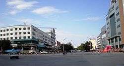 Usu in Tacheng Prefecture | |
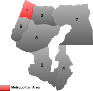
 Tacheng prefecture (red) in Ili prefecture (light red) and Xinjiang (orange) | |
| Country | People's Republic of China |
| Province | Xinjiang |
| Sub-provincial | Ili Prefecture |
| Time zone | UTC+8 (China Standard) |
| ISO 3166 code | CN-XJ-42 |
| Website | xjtc |
| Tacheng Prefecture | |||||||||||||
|---|---|---|---|---|---|---|---|---|---|---|---|---|---|
| Chinese name | |||||||||||||
| Simplified Chinese | 塔城地区 | ||||||||||||
| Traditional Chinese | 塔城地區 | ||||||||||||
| |||||||||||||
| Alternative Chinese name | |||||||||||||
| Simplified Chinese | 塔尔巴哈台地区 | ||||||||||||
| Traditional Chinese | 塔爾巴哈台地區 | ||||||||||||
| |||||||||||||
| Mongolian name | |||||||||||||
| Mongolian script | ᠲᠠᠷᠪᠠᠭᠠᠲᠠᠢ | ||||||||||||
| Uyghur name | |||||||||||||
| Uyghur | تارباغاتاي ۋىلايىتى | ||||||||||||
| |||||||||||||
| Kazakh name | |||||||||||||
| Kazakh | تارباعاتاي ايماعى Tarbaǵataı Aımaǵy Тарбағатай аймағы | ||||||||||||
Subdivisions
Tacheng prefecture is divided into 2 county level cities, 4 counties, and 1 autonomous county.
 | ||||||||||
| # | Name | Hanzi | Hanyu Pinyin | Uyghur (UEY) | Uyghur Latin (ULY) | Kazakh (Arabic script) | Kazakh Latin transcription | Population (2010 Census) | Area (km2) | Density (/km2) |
|---|---|---|---|---|---|---|---|---|---|---|
| 1 | Tacheng[1] | 塔城市 | Tǎchéng Shì | چۆچەك شەھىرى | Chöchek Shehiri | شاۋەشەك قالاسى | Sháýeshek qalasy | 161,037 | 4,007 | 40.18 |
| 2 | Usu[1] | 乌苏市 | Wūsū Shì | ۋۇسۇ شەھىرى | Usu Shehiri | شيحۋ قالاسى | Shıhý qalasy | 298,907 | 14,394 | 20.76 |
| 3 | Emin County[1] | 额敏县 | Émǐn Xiàn | دۆربىلجىن ناھىيىسى | Dörbiljin Nahiyisi | ءدوربىلجىن اۋدانى | Dórbiljin aýdany | 187,112 | 9,147 | 20.45 |
| 4 | Shawan County[1] | 沙湾县 | Shāwān Xiàn | ساۋەن ناھىيىسى | Saven Nahiyisi | ساۋان اۋدانى | Saýan aýdany | 365,196 | 12,460 | 29.30 |
| 5 | Toli County | 托里县 | Tuōlǐ Xiàn | تولى ناھىيىسى | Toli Nahiyisi | تولى اۋدانى | Toly aýdany | 93,098 | 19,992 | 4.65 |
| 6 | Yumin County[1] | 裕民县 | Yùmín Xiàn | چاغانتوقاي ناھىيىسى | Chaghantoqay Nahiyisi | شاعانتوعاي اۋدانى | Shaǵantoǵaı aýdany | 51,919 | 6,107 | 8.50 |
| 7 | Hoboksar Mongol Autonomous County | 和布克赛尔蒙古自治县 | Hébùkèsài'ěr Měnggǔ Zìzhìxiàn | ئاپتونوم ناھىيىسى قوبۇقسار موڭغۇل | Qobuqsar Mongghul Aptonom Nahiyisi | قوبىقسارى موڭعۇل اۆتونوميالى اۋدانى | Qobyqsary Mońǵul avtonomıaly aýdany | 62,100 | 28,784 | 2.15 |
Geography
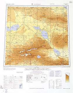
Map of Tacheng (labeled as T'A-CH'ENG (CHUGUCHAK)) in the International Map of the World (1960)
See Emin Valley, Tarbagatai Mountains, Saur Mountains, Gurbantünggüt Desert.
Heads
Secretary
- Xue Bin (薛斌)
Governors
- Baspaı Sholaquly 1945–1952[2]
- Aqanuly Sarqyt
- Muqııat Jarmuqamet (木合亚提·加尔木哈买提)
References
- The official spelling according to 中国地名录. Beijing: SinoMaps Press (中国地图出版社). 1997. ISBN 7-5031-1718-4.
- Баспай байдың ауылында. baq.kz. Retrieved 2019-09-08.
This article is issued from Wikipedia. The text is licensed under Creative Commons - Attribution - Sharealike. Additional terms may apply for the media files.