Yuli County
Yuli County as the official romanized name, also transliterated from Mongolian as Lopnur County (Lop Nur), is a county in the Xinjiang Uyghur Autonomous Region and is under the administration of the Bayin'gholin Mongol Autonomous Prefecture. It contains an area of 59,399 km2 (22,934 sq mi). According to the 2002 census, it has a population of 100,000.
Yuli County 尉犁县 · ᠯᠣᠪ ᠨᠠᠭᠤᠷ ᠰᠢᠶᠠᠨ · لوپنۇر ناھىيىسى Yülihsien | |
|---|---|
County | |
 | |
.png) Yuli County (red) within Bayingolin Prefecture (yellow) and Xinjiang | |
 Yuli Location of the seat in Xinjiang | |
| Coordinates: 41°20′38″N 86°15′40″E | |
| Country | People's Republic of China |
| Autonomous region | Xinjiang |
| Autonomous prefecture | Bayingolin |
| Area | |
| • Total | 59,401.78 km2 (22,935.16 sq mi) |
| Population | |
| • Total | 103,300 |
| • Density | 1.7/km2 (4.5/sq mi) |
| Ethnic groups | |
| • Major ethnic groups | Han Chinese, Uyghur[3] |
| Time zone | UTC+8 (China Standard) |
| Postal code | 841500 |
| Website | yuli |
| Yuli County | |||||||||||
|---|---|---|---|---|---|---|---|---|---|---|---|
| Chinese name | |||||||||||
| Simplified Chinese | 尉犁县 | ||||||||||
| Traditional Chinese | 尉犁縣 | ||||||||||
| |||||||||||
| Alternative Chinese name | |||||||||||
| Simplified Chinese | 罗布淖尔县 | ||||||||||
| Traditional Chinese | 羅布淖爾縣 | ||||||||||
| |||||||||||
| Second alternative Chinese name | |||||||||||
| Simplified Chinese | 罗布泊县 | ||||||||||
| Traditional Chinese | 羅布泊縣 | ||||||||||
| |||||||||||
| Mongolian name | |||||||||||
| Mongolian script | ᠯᠣᠪ ᠨᠠᠭᠤᠷ ᠰᠢᠶᠠᠨ | ||||||||||
| Uyghur name | |||||||||||
| Uyghur | لوپنۇر ناھىيىسى | ||||||||||
| |||||||||||
Name
The etymology was discussed in detail in the article On the Place Name Yuli and Rouran (《尉犁地名和柔然源流考》) by Li Shuhui (李树辉).
The name Yuli was postulated to have come from Turkic (J)yrægir (“one who is stationed; one who stays”), the name of a Turkic clan, and derived from yræ- (verb form yryk, “to be stationed in”) + -gir (adjectival suffix).
Both (J)yrægir and yryk were said to be recorded in the ancient dictionary Dīwān Lughāt al-Turk, although the exact Arabic-script forms are unknown, perhaps اُرَكِرْ Üregir, يُرَكِرْ Yüregir, the 15th clan of the Oghuz.
History
In 2016, Tuanjie was upgraded from a township to a town.[4]
In 2018, Xingping was upgraded from a township to a town.[5]
Geography
The county is bordered to the northeast by Toksun County.
Administrative divisions
Yuli County includes three towns and five townships:[1][2][5]
Towns (镇)
Townships (乡)
- Tarim Township[6] (Talimu; تارىم يېزىسى[7] / 塔里木乡), Dunkuotan Township (墩阔坦乡), Ka'erquga Township (喀尔曲尕乡), Aksopi Township[8] (Akesupu, Akesufu; 阿克苏普乡/阿克苏甫乡[8]), Gulebage Township (古勒巴格乡)
Others
- 兵团团场: 31团场, 32团场, 33团场, 34团场, 35团场
Demographics
As of 2015, 68,281 of the 103,143 residents of the county were Han Chinese, 33,752 were Uyghur and 1,110 were from other ethnic groups.[9]
As of 1999, 70.54% of the population of Yuli (Lopnur) County was Han Chinese and 28.68% of the population was Uyghur.[10]
As of 1997, several townships had a majority of Uyghur residents including Xingping Township (61.6%), Donghetan Township (东河滩乡) (98.5%), Ka'erquga Township (98.6%), Akesufu/Akesupu Township (90.1%), Gulebage Township (65.3%) and others.[3]
Transportation
Gallery
 Map including Yuli and surrounding region (DMA, 1982)
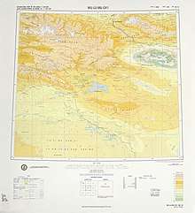 Map including Yuli (labeled as WEI-LI) and surrounding region from the International Map of the World (1975)
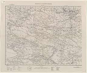 Map including eastern Yuli County area (1935)
.jpg)

.jpg)
See also
References
- 行政区划. 尉犁县政府网 (in Chinese). Retrieved 28 November 2019.
尉犁县行政区域面积6万平方公里,县辖5乡3镇,为尉犁镇、团结镇、兴平镇、塔里木乡、墩阔坦乡、喀尔曲尕乡、阿克苏甫乡、古勒巴格乡,另有肖唐管委会、尉北管委会。有生产建设兵团农二师驻县团场及州直驻县单位7个,县域总人口10.33万人。
- 尉犁县历史沿革 [Yuli County Historical Development] (in Chinese). XZQH.org. 30 January 2015. Retrieved 1 December 2019.
2003年,尉犁县总面积59401.78平方千米,总人口109431人,{...}2010年第六次人口普查,尉犁县常住总人口96068人,其中:尉犁镇22474人,塔里木乡6713人,兴平乡10871人,团结乡7258人,墩阔坦乡4163人,喀尔曲尕乡3590人,阿克苏普乡2765人,古勒巴格乡5530人,兵团三十一团9291人,农二师三十三团12320人,兵团三十四团11093人。【注:阿克苏甫乡为民政部门的写法,阿克苏普乡为统计部门的写法】
- 1997年尉犁县行政区划 [1997 Yuli County Administrative Divisions]. XZQH.org. 10 December 2010. Retrieved 4 April 2020.
面积59760.8平方千米,人口9万,有汉、维吾尔、蒙古、满等民族,其中汉族占70.2%{...}其中维吾尔族占90.1%
- 2016年统计用区划代码和城乡划分代码:尉犁县 [2016 Statistical Area Numbers and Rural-Urban Area Numbers: Yuli County] (in Chinese). National Bureau of Statistics of the People's Republic of China. 2016. Retrieved 14 January 2020.
统计用区划代码 名称 652823100000 尉犁镇 652823110000 团结镇 652823200000 塔里木乡 652823201000 兴平乡 652823203000 墩阔坦乡 652823204000 喀尔曲尕乡 652823205000 阿克苏普乡 652823206000 古勒巴格乡 652823501000 兵团三十一团 652823502000 兵团三十三团 652823503000 兵团三十四团
- 2018年统计用区划代码和城乡划分代码:尉犁县 [2018 Statistical Area Numbers and Rural-Urban Area Numbers: Yuli County] (in Chinese). National Bureau of Statistics of the People's Republic of China. 2018. Retrieved 30 November 2019.
统计用区划代码 名称 652823100000 尉犁镇 652823110000 团结镇 652823120000 兴平镇 652823200000 塔里木乡 652823203000 墩阔坦乡 652823204000 喀尔曲尕乡 652823205000 阿克苏普乡 652823206000 古勒巴格乡 652823501000 兵团三十一团 652823502000 兵团三十三团 652823503000 兵团三十四团
- Tarim (Approved - N) at GEOnet Names Server, United States National Geospatial-Intelligence Agency
- تارىم (Variant Non-Roman Script - VS) at GEOnet Names Server, United States National Geospatial-Intelligence Agency
- Xie Yuzhong 解玉忠 (2003). 地名中的新疆 (in Chinese). Ürümqi: 新疆人民出版社. p. 143. ISBN 7-228-08004-1.
阿克苏甫 Aksopi {...}
- 3-7 各地、州、市、县(市)分民族人口数 (in Chinese). شىنجاڭ ئۇيغۇر ئاپتونوم رايونى 新疆维吾尔自治区统计局 Statistic Bureau of Xinjiang Uygur Autonomous Region. 15 March 2017. Archived from the original on 11 October 2017. Retrieved 3 September 2017.
- Morris Rossabi, ed. (2004). Governing China’s Multiethnic Frontiers (PDF). University of Washington Press. p. 178. ISBN 0-295-98390-6.
| Wikimedia Commons has media related to Yuli County. |
| Authority control |
|
|---|