Manzhouli
Manzhouli (Chinese: 满洲里; pinyin: Mǎnzhōulǐ; Mongolian: Манжуур хот; ᠮᠠᠨᠵᠤᠤᠷ ᠬᠣᠲᠠ) is a sub-prefectural city located in Hulunbuir prefecture-level city, Inner Mongolia Autonomous Region, China. Located on the border with Russia, it is a major land port of entry. It has an area of 696.3 square kilometres (268.8 sq mi) and a population of almost 250,000 (in 2010).
Manzhouli 满洲里市 • ᠮᠠᠨᠵᠤᠤᠷᠬᠣᠲᠠ | |
|---|---|
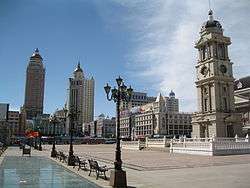 Manzhouli city centre | |
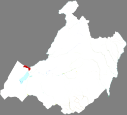 Manzhouli in Hulunbuir | |
 Manzhouli Location in Inner Mongolia | |
| Coordinates: 49°35′53″N 117°22′44″E | |
| Country | People's Republic of China |
| Region | Inner Mongolia |
| Prefecture-level city | Hulunbuir |
| Area | |
| • Total | 732.4 km2 (282.8 sq mi) |
| Population (2017)[1] | |
| • Total | 212,000 |
| • Density | 290/km2 (750/sq mi) |
| Time zone | UTC+8 (China Standard) |
| Postal code | 021400 |
| Area code(s) | 0470 |
| Website | www |
| Manzhouli | |||||||||
|---|---|---|---|---|---|---|---|---|---|
| Traditional Chinese | 滿洲里 | ||||||||
| Simplified Chinese | 满洲里 | ||||||||
| Postal | Manchouli | ||||||||
| |||||||||
History
In ancient times the area was inhabited by the Donghu, the Xiongnu, the Xianbei, the Khitan, and the Mongols. During the decline of China's last dynasty, the Russian Empire forced the house of Qing (1644–1912) to cede the Outer Manchurian territory in the 1858 Treaty of Aigun. That treaty effectively made the Argun River, which originates in this area, the border between the China and Russia.
In 1901, the China Far East Railway was completed in accordance with the Sino-Russian Secret Treaty of 1896, linking Siberia, northeast China ("(Inner) Manchuria"), and the Russian Far East. A settlement then formed around Manchzhuriya Station, the first stop within Manchuria for Russians. It was the beginning of the modern city of Manzhouli and the name of Manzhouli came from Russian Манжули (Manzhuli).
In 1905, Manzhouli was designated a trading center, greatly boosting Manzhouli's growth. In 1908 the Manzhouli customs was set up. Under the Republic of China, Manzhouli came under the jurisdiction of the province of Hsingan. In 1927, Manzhouli was designated as a city. Although with Hsingan and surrounding areas, Manzhouli came under Japanese control in 1931, and was part of the Empire of Manchuria from 1932 to 1945. It became part of Inner Mongolia under the China from 1946.
In 1992, Manzhouli became one of the first land border cities opened up by the People's Republic of China. It has since experienced somewhat of a boom as a center of border trade between China and Russia.[2]
Geography and climate
Manzhouli is located in the western part of the Hulunbuir prefecture-level city. To the east, south and west it borders New Barghu Left Banner and New Barghu Right Banner, also in Hulunbuir, and Russia to the north, with which it shares a border 54 kilometres (34 mi) long. The Russian townlet of Zabaykalsk is situated immediately north of Abagaitu Islet and Manzhouli.
Manzhouli is located on the Hulunbuir grasslands. Lake Hulun to its immediate south is the PRC's fifth largest freshwater lake with an area of 2,600 square kilometers (1,000 sq mi) and an average depth of just 5 meters (16 ft).
Manzhouli has a rather dry, monsoon-influenced humid continental climate (Köppen Dwb), with temperatures in winter capable of plummeting below −40 °C (−40 °F). However, in each month there is more than 55% of possible sunshine, and over three-fourths of annual precipitation occurs from June to August.
| Climate data for Manzhouli (1981–2010 normals, extremes 1971–2010) | |||||||||||||
|---|---|---|---|---|---|---|---|---|---|---|---|---|---|
| Month | Jan | Feb | Mar | Apr | May | Jun | Jul | Aug | Sep | Oct | Nov | Dec | Year |
| Record high °C (°F) | −0.6 (30.9) |
8.1 (46.6) |
18.4 (65.1) |
30.0 (86.0) |
34.3 (93.7) |
40.2 (104.4) |
40.5 (104.9) |
36.6 (97.9) |
34.0 (93.2) |
25.6 (78.1) |
11.5 (52.7) |
1.2 (34.2) |
40.5 (104.9) |
| Average high °C (°F) | −17.3 (0.9) |
−11.5 (11.3) |
−2.1 (28.2) |
9.6 (49.3) |
18.4 (65.1) |
24.6 (76.3) |
26.2 (79.2) |
24.2 (75.6) |
17.3 (63.1) |
7.7 (45.9) |
−5.3 (22.5) |
−14.6 (5.7) |
6.4 (43.6) |
| Daily mean °C (°F) | −23.2 (−9.8) |
−18.8 (−1.8) |
−9.3 (15.3) |
2.5 (36.5) |
11.4 (52.5) |
18.1 (64.6) |
20.3 (68.5) |
17.9 (64.2) |
10.2 (50.4) |
0.6 (33.1) |
−11.9 (10.6) |
−20.2 (−4.4) |
−0.2 (31.6) |
| Average low °C (°F) | −28.0 (−18.4) |
−24.5 (−12.1) |
−15.9 (3.4) |
−4.6 (23.7) |
3.4 (38.1) |
10.8 (51.4) |
14.1 (57.4) |
11.8 (53.2) |
3.8 (38.8) |
−5.5 (22.1) |
−17.0 (1.4) |
−24.8 (−12.6) |
−6.4 (20.5) |
| Record low °C (°F) | −43.8 (−46.8) |
−42.5 (−44.5) |
−34.0 (−29.2) |
−21.6 (−6.9) |
−11.6 (11.1) |
−2.4 (27.7) |
2.5 (36.5) |
0.8 (33.4) |
−9.5 (14.9) |
−23.8 (−10.8) |
−35.1 (−31.2) |
−39.4 (−38.9) |
−43.8 (−46.8) |
| Average precipitation mm (inches) | 1.4 (0.06) |
0.7 (0.03) |
2.9 (0.11) |
6.8 (0.27) |
18.7 (0.74) |
50.9 (2.00) |
90.9 (3.58) |
69.0 (2.72) |
29.8 (1.17) |
7.7 (0.30) |
2.1 (0.08) |
2.1 (0.08) |
283.0 (11.14) |
| Average precipitation days (≥ 0.1 mm) | 1.8 | 1.7 | 2.7 | 3.5 | 5.3 | 10.8 | 13.9 | 12.1 | 8.1 | 3.6 | 2.8 | 3.6 | 69.9 |
| Average relative humidity (%) | 74 | 70 | 60 | 44 | 41 | 55 | 67 | 68 | 62 | 58 | 69 | 74 | 62 |
| Mean daily sunshine hours | 6 | 7 | 8 | 9 | 9 | 10 | 9 | 9 | 8 | 7 | 6 | 5 | 8 |
| Percent possible sunshine | 63 | 72 | 70 | 63 | 61 | 60 | 56 | 59 | 61 | 68 | 63 | 59 | 64 |
| Source 1: China Meteorological Administration,[3] Weather China (precipitation days 1971–2000)[4] | |||||||||||||
| Source 2: World Climate Guide (sun only) | |||||||||||||
Administration
Manzhouli is divided into ten subdistricts and one town. Six of the subdistricts of Manzhouli are grouped into Jalainur District. Technically however, only a prefecture-level city (half a level higher than Manzhouli) can have districts, so Jalainur District belongs to Hunlunbuir administratively though it is under Manzhouli's administration and covered in the statistics of Manzhouli.[5]
Tourism
The border crossing with Russia is a tourist attraction. The Manzhouli China-Russia Border Tourist Area is a destination that brings together the border gate, a giant Matryoshka doll shaped hotel, and park filled with Matryoshka dolls. Other attractions within the scenic area are the No 41 Border Monument and the Locomotive Square.[6] It had been rated as a AAAAA (5A) tourist attraction before being downgraded to 4A.
Manzhouli Ice & Snow Festival takes place every winter from some time in February to early March. This is a smaller version of the Harbin International Ice and Snow Sculpture Festival.
Economy
Manzhouli is China's busiest land port of entry, and is responsible for 60% of all imports from and exports to Eastern Europe.
Demographics
| Historical population | ||
|---|---|---|
| Year | Pop. | ±% |
| 1990 | 137,000 | — |
| 2004 | 160,000 | +16.8% |
| 2007 | 163,441 | +2.2% |
| 2010 | 249,473 | +52.6% |
| Population size may be affected by changes on administrative divisions. | ||
Ninety-five percent of Manzhouli's population is Han Chinese. The remainder are Buryat, Russian, Mongol, Manchu, or of other ethnicities.
Transportation
Railway
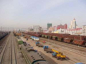
Trains from Beijing to Moscow on the Trans-Manchurian branch of the Trans-Siberian Railway pass through Manzhouli Railway Station. There are also tourist lines to Chita, Krasnokamensk, Irkutsk, and Ulan Ude.
A break of gauge multi-modal transshipment facility was completed in 2008 across the Russian border in Zabaikalsk.
Air
Manzhouli Airport is located in the western part of the city. Passengers can fly to Beijing and Inner Mongolia's capital city Hohhot from the airport as well as the Russian city of Chita and the Mongolian capital city Ulaanbaatar via Choibalsan.[7]
Highway
- By China National Highway 301 linked to Inner Mongolia and Heilongjiang cities.
Sister cities
Manzhouli is twinned with the following sister cities.[8]
| City | Region | Country |
|---|---|---|
| Chita | ||
| Krasnokamensk | ||
| Ulan-Ude |
References
- Ministry of Housing and Urban-Rural Development, ed. (2019). China Urban Construction Statistical Yearbook 2017. Beijing: China Statistics Press. p. 46. Retrieved 11 January 2020.
- Siberia's black market logging (BBC News, 2008-04-09)
- 中国气象数据网 - WeatherBk Data (in Chinese). China Meteorological Administration. Retrieved 2020-04-15.
- "Code of administrative divisions(County level divisions and the higher) of People's Republic of China in 2013". Ministry of Civil Affairs of the People's Republic of China.
- "Manzhouli China-Russia Border Tourist Area". China Daily. December 12, 2017.
- Mongolian Hunnu Air launches flight to Manchuria
- Sister cities Archived 2013-05-14 at the Wayback Machine
External links
| Wikivoyage has a travel guide for Manzhouli. |
| Wikimedia Commons has media related to Manzhouli. |
- Official Site (Simplified Chinese)
- Information Portal (Simplified Chinese)
- Manzhouli : Where the Clock Always Strikes Nine Manzhouli: Photos and observations
- Manzhouli : City of the Plain Pictures and Stories of a trip to Manzhouli at www.pocopico.com
- St. Jonah of Manchuria (Russian Orthodox Saint who lived and died in Manzhouli)
- Post codes of Inner Mongolia (English)
| Authority control |
|
|---|