Xianning
Xianning (simplified Chinese: 咸宁; traditional Chinese: 咸寧/咸甯; pinyin: Xiánníng) is a prefecture-level city in southeastern Hubei province, People's Republic of China, bordering Jiangxi to the southeast and Hunan to the southwest. It is known as the "City of Osmanthus".
Xianning 咸宁市 Sienning | |
|---|---|
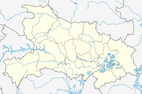
.png) Location of Xianning City jurisdiction in Hubei | |
 Xianning Location of the city centre in Hubei | |
| Coordinates (Xianning municipal government): 29°50′29″N 114°19′21″E | |
| Country | People's Republic of China |
| Province | Hubei |
| Municipal seat | Xian'an District |
| Area | |
| • Prefecture-level city | 9,750 km2 (3,760 sq mi) |
| • Urban (2017)[1] | 165.00 km2 (63.71 sq mi) |
| • Districts[1] | 1,503.1 km2 (580.4 sq mi) |
| Population (2010 census) | |
| • Prefecture-level city | 2,462,583 |
| • Density | 250/km2 (650/sq mi) |
| • Urban (2017)[1] | 412,400 |
| • Urban density | 2,500/km2 (6,500/sq mi) |
| • Districts[1] | 676,000 |
| Time zone | UTC+8 (China Standard) |
| Postal code | 437000 |
| Area code(s) | 0715 |
| ISO 3166 code | CN-HB-12 |
| Licence plate prefixes | 鄂L |
| Website | xianning |
Geography and climate
Xianning is located in southeastern Hubei province, just south of Wuhan, between the southern bank of the Yangtze River in the north and the Mufu Mountains in the south. It borders Jiangxi to the southeast and Hunan to the southwest. It is called Hubei's southern gateway. Xianning is hilly and mountainous (especially in its southern part), with some flatlands (mostly in the north) and lakes. It was home to 2,462,583 inhabitants as of the 2010 census whom 512,517 lived in the built-up (or metro) area made of Xia'nan District. Its area is 1,504 square kilometres (581 sq mi), 56% of which is forested.. Its proximity to Wuhan is transforming the city into an outer suburb of the Hubei's capital.
Xianning has a humid subtropical climate (Köppen Cfa). The normal monthly mean temperature ranges from 4.6 °C (40.3 °F) in January to 29.2 °C (84.6 °F) in July; the annual mean temperature is 17.22 °C (63.0 °F) and annual precipitation is just below 1,600 millimetres (63.0 in).[2]
| Climate data for Xianning (1981–2010 normals) | |||||||||||||
|---|---|---|---|---|---|---|---|---|---|---|---|---|---|
| Month | Jan | Feb | Mar | Apr | May | Jun | Jul | Aug | Sep | Oct | Nov | Dec | Year |
| Average high °C (°F) | 8.7 (47.7) |
11.1 (52.0) |
15.3 (59.5) |
22.5 (72.5) |
27.5 (81.5) |
30.4 (86.7) |
33.8 (92.8) |
32.9 (91.2) |
28.6 (83.5) |
23.2 (73.8) |
17.5 (63.5) |
11.5 (52.7) |
21.9 (71.5) |
| Daily mean °C (°F) | 4.6 (40.3) |
6.9 (44.4) |
10.9 (51.6) |
17.5 (63.5) |
22.5 (72.5) |
25.9 (78.6) |
29.2 (84.6) |
28.2 (82.8) |
23.8 (74.8) |
18.2 (64.8) |
12.3 (54.1) |
6.6 (43.9) |
17.2 (63.0) |
| Average low °C (°F) | 1.6 (34.9) |
3.8 (38.8) |
7.4 (45.3) |
13.6 (56.5) |
18.5 (65.3) |
22.4 (72.3) |
25.6 (78.1) |
24.7 (76.5) |
20.3 (68.5) |
14.5 (58.1) |
8.7 (47.7) |
3.3 (37.9) |
13.7 (56.7) |
| Average precipitation mm (inches) | 71.1 (2.80) |
86.2 (3.39) |
132.1 (5.20) |
180.1 (7.09) |
197.0 (7.76) |
230.2 (9.06) |
234.9 (9.25) |
156.6 (6.17) |
93.3 (3.67) |
93.0 (3.66) |
78.9 (3.11) |
45.9 (1.81) |
1,599.3 (62.97) |
| Average relative humidity (%) | 79 | 77 | 78 | 77 | 76 | 78 | 75 | 78 | 78 | 77 | 77 | 76 | 77 |
| Source: China Meteorological Administration[2] | |||||||||||||
History
Xianning was under the jurisdiction of Nanjun County during the Qin dynasty. At the end of the Han dynasty, Xianning became a strategic point where conflict occurred. During the Cultural Revolution, it was an important area for the Hunan, Hubei and Jiangxi Revolutionary Bases.[3]
Administration
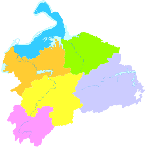
Xianning has 1 district, 4 counties, 1 county-level city and 1 other area.[4][5][6][7]
District:
- Xian'an District (咸安区) (location of Xianning's main urban area, i.e. the place that low-resolution maps would label as "Xianning")
Counties:
City:
Other Area:
| Map |
|---|
 Advanced Technology
Industry Area Tongshan
County Chibi (city) |
Demographics
Xianning has a population of 2,772,000 people. Most of the inhabitants of Xianning are Han; only 4,785 are from other ethnic groups including Hui, Tujia, Zhuang, Miao, Manchu, and Dong. The place with the largest ethnic minority population is in Chibi City.
Economy

Agriculture and forestry are two of Xianning's biggest industries. It is known by the three names, "City of Osmanthus", "City of Nan Bamboo", and "City of Tea". There are more than 1 million mu (~151,822 English acres) of "Nan" Bamboo, 30,000 Chinese acres of osmanthus, and more than 150,000 Chinese acres of tea.
Mineral resources are also an important part of Xianning's economy. Niobium, gold, magnesium, antimony, monazite, coal, manganese, vanadium, mica, and marble are all mined or quarried in Xianning.
Xianning Nuclear Power Plant is under construction near Dafan Town, Tongshan County. On 17 August 2010, the Shaw Group announced an agreement with State Nuclear Power Engineering Corp. Ltd., a subsidiary of China's State Nuclear Power Technology Corp. Ltd. (SNPTC), to add two new AP1000 units at the Xianning Nuclear Power Plant.[10]
Transportation
Xianning has major rail lines, including the Beijing-Guangzhou line, many national highways, and a large stretch of the Yangtze River, making it an important transportation and shipping center.
As of 2015, four different train stations located in or near Xianning's main urban area have "Xianning" in their name; several other stations are located elsewhere within the prefecture-level city.
There are two passenger train stations on the "conventional" Beijing-Guangzhou line within the Prefecture-level city of Xianning - the Xianning Railway Station in urban area itself (80 kilometres (50 mi) from Wuhan's Wuchang train station), and the one in Chibi (118 kilometres (73 mi) from Wuchang) - are usually the first and the second stops for the slower trains leaving Wuchang toward Changsha and Guangzhou. Typical travel times from Wuchang is 40-50 min and 1 hour 20 min, respectively.[11]
The new Wuhan–Guangzhou High-Speed Railway has Xianning North Railway Station, which is located on the northern outskirts of the city's main urban area, about 2 km (1.2 mi) northeast of Xianning Railway Station.
The Wuhan–Xianning Intercity Railway (part of the future Wuhan Metropolitan Area Intercity Railway system), opened in December 2013, provides direct rail service from Wuhan's Wuchang Railway Station to Xianning city center. It has two stations in the city's main urban area: Xianning East Railway Station in the downtown Xianning, and Xianning South, the end-of-line (dead-end) station in the industrial area south of downtown. When the system was under construction, the expected travel time from Wuchang to Xianning was stated to be 28 min,[12][13] but as of 2015, the typical scheduled time from Wuchang to Xianning South (91 km or 57 mi) is more like 70 to 100 min.[14]
Tourism

Xianning's biggest tourist draw is its natural scenery. There are many sites including Taiyi Cave (太乙洞), Star Bamboo Sea (星星竹海), Mount Jiugong (九宫山, in Tongshan County), Lushui Lake (陆水湖), as well as the historical site the Chibi Ancient Ruins (赤壁遗址).
At the "Underground Project 131" site, some 15 kilometres (9.3 mi) southeast of downtown Xianning (within Xian'an District, tourists can visit a system of tunnels that were built in 1969-71 to accommodate national military headquarters in the case of a war, but never used.[15] The Xianning Sports Centre Stadium is located in the city. It has a capacity of 12,000 and it attracts many football fans from the region.
References
- Ministry of Housing and Urban-Rural Development, ed. (2019). China Urban Construction Statistical Yearbook 2017. Beijing: China Statistics Press. p. 66. Retrieved 11 January 2020.
- 中国气象数据网 - WeatherBk Data (in Chinese). China Meteorological Administration. Retrieved 2020-04-15.
- "Brief Introduction of Xianning City - English Channel xianning.gov.cn". english.xianning.gov.cn. Retrieved 2016-05-06.
- 咸宁市行政区划 (in Chinese). Xianning People's Government. Archived from the original on 12 June 2018. Retrieved 3 March 2018.
咸宁市辖嘉鱼县、通城县、崇阳县、通山县、赤壁市、咸安区四县一市一区和一个高新技术产业园区,共设12个乡、51个镇、6个办事处,下辖1049个村民委员会、10145个村民小组。
- 咸宁市历史沿革 (in Chinese). XZQH.org. 7 December 2011. Retrieved 3 March 2018.
2000年第五次全国人口普查,咸宁市总人口2700678人。其中:咸安区567598人,嘉鱼县358646人,通城县427867人,崇阳县456792人,通山县378849人,赤壁市510926人。 2004年末,咸宁市总面积10022平方千米,总人口约276.9万人。辖1个市辖区、4个县,代管1个县级市。共有6个街道、51个镇、12个乡,131个居委会、1034个村委会。
- 2016年统计用区划代码和城乡划分代码:咸宁市 (in Chinese). National Bureau of Statistics of the People's Republic of China. 2016. Retrieved 3 March 2018.
统计用区划代码 名称 421201000000 市辖区 421202000000 咸安区 421221000000 嘉鱼县 421222000000 通城县 421223000000 崇阳县 421224000000 通山县 421281000000 赤壁市
- 湖北咸宁市. 博雅地名网 (in Chinese). Retrieved 3 March 2018.
- 咸宁市行政区划 (in Chinese). Xianning People's Government. Archived from the original on 12 June 2018. Retrieved 3 March 2018.
咸宁市辖{...}和一个高新技术产业园区,{...}咸宁高新技术产业园区下辖横沟桥镇;
- 咸安区人民政府 (in Chinese). Xian'an District People's Government. Retrieved 6 March 2018.
【咸宁高新区托管咸安区横沟桥镇】2015年11月26日,咸宁高新区管委会和咸安区政府举行签约仪式,正式托管咸安区横沟桥镇。
- BUSINESS WIRE
- Xianning schedule search at tielu.org Archived December 5, 2016, at the Wayback Machine
- 武咸城际铁路将通车 13站串起湖北首条市郊客运线. huochepiao.com (in Chinese). December 16, 2013. Archived from the original on December 19, 2013. Retrieved December 18, 2013.
- See the detailed system map at "Archived copy". Archived from the original on 2013-12-19. Retrieved 2013-12-18.CS1 maint: archived copy as title (link)
- Xianning South train schedule Archived March 23, 2015, at the Wayback Machine (in Chinese)
- 林彪为毛主席修建的地下避难所“131地下工程” [Lin Biao constructed the "131 Underground Project" as a haven for Chairman Mao]. cqzg.cn (in Chinese).
- Sohan Das. "Labuan to twin with Xianning". Daily Express. Archived from the original on 4 April 2017. Retrieved 4 April 2017.
External links
| Wikimedia Commons has media related to Xianning. |
- Xianning City People's Government, Official Website (in Chinese)
Hubei topics | |
|---|---|
Wuhan (capital) | |
| General | |
| Geography |
|
| Education | |
| Culture |
|
| Cuisine |
|
| Visitor attractions |
|
| |
| Authority control |
|
|---|