Ili Kazakh Autonomous Prefecture
Ili (also as Yili; Chinese: 伊犁哈萨克自治州; pinyin: Yīlí Hǎsàkè Zìzhìzhōu) is an autonomous prefecture for Kazakh people in Xinjiang, China, one of 5 autonomous prefectures in Xinjiang. Yining City is its capital. It is bordered by Mongolia, Russian Federation and Republic of Kazakhstan on the northeast to southwest, with a boundary line of 2,019 kilometers. Including Khorgas, Bakhty (巴克图) and Jeminay, there are 9 ports of entry at the national level. With the unique location advantage, Ili has been an important commercial hub and international channel of opening up to the west.
Ili Prefecture 伊犁州 ىله وبلىسى ئىلى ئوبلاستى | |
|---|---|
Sub-provincial autonomous prefecture | |
| 伊犁哈萨克自治州 ىله قازاق اۆتونومىيالى وبلىسى ئىلى قازاق ئاپتونوم ئوبلاستى Ili Kazakh Autonomous Prefecture | |
 Yining (Ghulja), seat of Ili | |
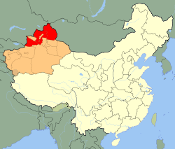 Ili Prefecture (red) in Xinjiang (orange) | |
| Coordinates (Ili Prefecture government): 43.92°N 81.32°E | |
| Country | People's Republic of China |
| Region | Xinjiang |
| Prefecture seat | Yining (Ghulja) |
| Area | |
| • Land | 56,381.52 km2 (21,769.03 sq mi) |
| • inc. Altay & Tacheng | 268,778.71 km2 (103,776.04 sq mi) |
| Population (2018) | |
| • Total | 4,582,500 |
| Time zone | UTC+8 (China Standard) |
| ISO 3166 code | CN-XJ-40 |
| GDP (2014) | CNY 164.0 billion US$25.2 billion (including Altay & Tacheng) |
| - per capita | CNY 34,119 US$5,249 (including Altay & Tacheng) |
| Ili Kazakh Autonomous Prefecture | |||||||||||
|---|---|---|---|---|---|---|---|---|---|---|---|
| Chinese name | |||||||||||
| Simplified Chinese | 伊犁哈萨克自治州 | ||||||||||
| Traditional Chinese | 伊犁哈薩克自治州 | ||||||||||
| |||||||||||
| Dunganese name | |||||||||||
| Dungan | Йили Хасакə Зыҗыҗу | ||||||||||
| Romanization | Jili Xasakə Zьⱬьⱬu | ||||||||||
| Uyghur name | |||||||||||
| Uyghur | ئىلى قازاق ئاپتونوم ئوبلاستى | ||||||||||
| |||||||||||
| Kazakh name | |||||||||||
| Kazakh | ىله قازاق اۆتونومىيالى وبلىسى
Ile Qazaq aýtonomııalyq oblysy Іле Қазақ аутономиялық облысы | ||||||||||
The autonomous prefecture covers an area of 268,591 square kilometers, accounting for 16.18% of Xinjiang.[1] As of 2018, the prefecture has a registered population (户籍人口) of 4,582,500, of which 2,745,500 are minorities (or 59.91% of registered population). Direct-administered regions (直辖区域) within the prefecture cover 56,622 square kilometers (21.08% of total area) and have a population of 2,930,600 (or 63.95% of registered population).[2]
The Kazakh autonomous prefecture of Ili (伊犁哈萨克自治州) is a special case of administrative divisions in China, its legal status is actually an administrative division at prefecture - level. It is the only autonomous prefecture in the country that has both directly administered county-level divisions and prefectures under its jurisdiction. When the People's Republic of China was established in 1949, the 3 prefectures of Altay, Ili and Tacheng were directly under the leadership of Xinjiang provincial government. The Mongol autonomous prefecture of Bortala was founded from Bole, Jinghe and Wenquan, 3 counties of Ili Prefecture (伊犁专区) in July 1954. The Kazakh autonomous prefecture of Ili had 3 prefectures of Altay, Ili and Tacheng under its administration when it was established in November 1954. The Ili Prefecture (伊犁专区) firstly ceased to be as a separate prefecture in December 1955, its county-level administrative units were directly administered by the autonomous prefecture of Ili. Since then, the Kazakh autonomous prefecture of Ili has existed as a separate administrative division. Its administrative divisions have either been reduced to the geographical scope of the former Ili Prefecture or expanded back to the territory of the former 3 prefectures. As a separate administrative unit, Ili Prefecture (伊犁地区) existed until its final dissolution in 2001.
History

Early history
Before the advent of the Qin dynasty (221 BC – 206 BC), Ili was occupied by the Ussuns, a tributary tribe of the Huns. The Ussuns were driven away in the 6th century AD by the Northern Xiongnu, who established the First Turkic Khaganate in 552. Later this Khulja territory became a dependency of Dzungaria. During the Tang dynasty (618–907), the khanate became the Protectorate General to Pacify the West of the Tang Empire.
The Uyghur Khaganate and in the 12th century the Kara-Khitai, took possession of the area in turn. Genghis Khan conquered Kulja in the 13th century and the Mongol Khans resided in the valley of the Ili. It is supposed that the Oirats conquered it at the end of the 16th or the beginning of the 17th century.
Qing dynasty
The Oirats, or more precisely Dzungars, controlled both Dzungaria and the Ili Basin until 1755 as the Dzungar Khanate, when it was annexed by the Manchu-run Qing dynasty under the Qianlong Emperor. Having defeated the Dzungars in the Dzungarian and Ili Basins, as well as the Afaqi Khojas in Kashgaria, the Qing court decided to make the Ili basin the main base of their control in Xinjiang.
In the 1760s, the Qing built nine fortified towns (九城) in the Ili Basin:
| Original Chinese name | Chinese | Turki (Uyghur) name[3] | Modern name of the location[4] | Notes |
|---|---|---|---|---|
| Huiyuan Cheng | 惠远城 | Kürä Shahr | Huiyuan Town (惠远镇) in Huocheng County | The Old Huiyuan was the residence of the General of Ili from 1765 to 1866. The New Huiyuan was the residence of the General of Ili from 1894 to 1912. Also known as New Kulja, Manchu Kulja, or Ili at the time. |
| Ningyuan Cheng | 宁远城 | Kulja (Ghulja) | Yining City | Also was known as Old Kulja or Taranchi Kulja. County seat of Ningyuan County (1888–1914) and Yining County (1914–1952) |
| Huining Cheng | 惠宁城 | Bayandai | Bayandai Town (巴彦岱镇) within Yining City, some 10[5] to 18[6] km to the west of the Yining center city | |
| Taleqi Cheng | 塔勒奇城 | Tarchi | Within Huocheng County | |
| Zhande Cheng | 瞻德城 | Chaghan Usu | Qingshuihe Town (清水河镇) in Huocheng County | |
| Guangren Cheng | 广仁城 | Ukurborosuk | Lucaogou Town (芦草沟镇) in Huocheng County, NE of Qingshuihe | |
| Gongchen Cheng | 拱宸城 | Khorgos | Khorgas City (霍尔果斯市) | |
| Xichun Cheng | 熙春城 | Khara Bulaq | Area commonly referred to as Chengpanzi (城盘子) in the Hanbin Township (汉宾乡) within Yining City, a few km west of the city center | |
| Suiding Cheng | 绥定城 | Ukharliq | Shuiding Town (水定镇), county seat of Huocheng County since 1966 | General of Ili's residence 1762–1765 and 1883–1894, when it became known as New/Manchu/Chinese Kulja. County seat of Suiding County (1888–1965) and Shuiding County (1965–1966). Renamed Shuiding in 1965. |
Huiyuan Cheng, as the seat of the General of Ili, the chief commander of the Qing troops in Xinjiang, became the administrative capital of the region. It was provided with a large penal establishment and a strong garrison. This city was called New Kulja, Manhcu Kulja, Chinese Kulja, or Ili by the Russians and Westerners, to distinguish it from Nigyuan/Yining, known as Old Kulja or Taranchi Kulja.
The first General of Ili was Ming Rui. The Qing tradition, unbroken until the days of Zuo Zongtang in the 1870s, was to only appoint Manchus as officials in Xinjiang.
During the insurrection of 1864 the Dungans and Taranchis of the area formed the Taranchi Sultanate. Huiyuan (Manchu Kulja) was the last Qing fortress in the Ili Valley to fall to the rebels. The insurgent Dungans massacred most of Manchu Kulja's inhabitants; Governor General Mingsioi (Ming Xü) assembled his family and staff in his mansion, and blew it up, dying under its ruins.
The insurrection led to the occupation of the Ili basin (Kulja in contemporary Western terms) by the Russians in 1871. Ten years later, part of the territory was restored to China, and its boundary with Russia was assigned in accordance with the Treaty of Saint Petersburg (1881).
In October 1884, the Qing Government officially approved the foundation of Xinjiang Province. First of all, a major reform of General Ili system was made, and the Amban (军府制) and Baig systems (伯克制) were abolished and replaced by circuit, urban prefecture, prefecture and county systems. Although General Ili still existed, but its name was changed to "Ili Garrison General" (伊犁驻防将军). its power and management scope greatly were reduced, no longer the military affairs in the entire territory of Xinjiang, only the military and defensive affairs in Ili and Tacheng, and the Ili Garrison General and Xinjiang Grand coordinator (新疆巡抚) were separate directly under the Qing Government. As a sudivision of Xinjiang Province, Yita Circuit (伊塔道) was formed in Ili and Tacheng in 1888, it was headquartered in Ningyuan County (present Yining). Yita Circuit was divided into Ili Prefecture (Yili Fu, 伊犁府), Tacheng Direct-administered Division (塔城直隶厅) and Jinghe Direct-administered Division (精河直隶厅). Meanwhile, Ili Garrison General in charge of frontier defence and station troops, was headquartered in Huiyuan Town. Altay region was formed from Khovd (科布多; headquartered in Khovd Town) in 1904.[7]
Modern times
The Xinhai Revolution broke out in October 1911. Under the leadship of Yang Zuanxu (楊纘緒), a general of Ili New Army, an armed rebellion against Qing Government broke out on January 7, 1912. The rebels occupied Huiyuan Town and killed Zhi Rui (志锐), the Ili Garrison General, whose predecessor Guang Fu (广福) served as the military governor (都督) of Ili provisional government. On February 12, 1912, the Provisional Government of the Republic of China was established in Beijing, and on March 15, the Beijing government ordered Yuan Dahua (袁大化) of the Xinjiang Grand Goordinator (新疆巡抚) to end the Qing dynasty's rule in Xinjiang. The conflict between the two sides was over, the position of military governor (都督) replaced grand goordinator (巡抚). On April 25, Yuan Dahua was forced to announce his resignation from the grand goordinator of Xinjiang. On May 18, with shrewdness and actual strength, Yang Zengxin (杨增新) was recommended for the Military Governor of Xinjiang, meanwhile the both sides continued peace negotiations. On July 8, the two sides signed a peace agreement, that the position of Garrison General of Ili (伊犁驻防将军) was replaced by Defence Governor of Ili (伊犁镇边使) with the responsibilities and rights by the former garrison general of Ili. Guang Fu (广福) still served as the Defence Governor of Ili (伊犁镇边使) under the jurisdiction of Beijing central government. The two sides confirmed republican and democratic system, Yang Zengxin presided over the military and political affairs, and recognized Yang Zengxin as the top military and political chief in the whole territory of Xinjiang. In August 1912, the Nationalist Government adjusted administrative divisions, the Defence Governor of Ili (伊犁镇边使) headquartered in Huiyuan Town, the Counsellor (参赞) established from Tacheng and the Business Executive (办事长官) found in Altay were directly under the central government, as a division of local civil affairs, Yita Circuit (伊塔道) was retained and under the administraion of the Defence Governor of Ili (伊犁镇边使).
The position of Ili Defence Governor (伊犁镇边使) was vacant after that Guang Fu died of illness on February 1, 1914. Yang Zengxin, the Military Governor of Xinjiang flew a petition to Beiyang government, finally Yang Feixia (杨飞霞) held the position of Ili Defence Governor (伊犁镇守使), its administrative jurisdiction was changed to Xinjiang Province from the central government. Yita Circuit was divided into Ili and Tacheng two circuits, the circuit governor of Tacheng (塔城道尹) replaced the counsellor of Tacheng (塔城参赞) with the establishment of Tacheng Circuit (塔城道) in 1916. The Beiyang government assigned the Altay Chief to Xinjiang Province and Ashan Circuit (阿山道) of Xinjiang was established from the Altay region in 1919. With the decree for the abolition of minggans (千户长) and centenarii (百户长), and the establishment of district and township divisions issued in August 1939, Kazakh pastoralist affairs was gradually integrated into Local government services.[7]
Ili Prefecure (伊犁专区) was established in 1943, there were 11 counties and Xinyuan Division (新源设治局, present Xinyuan County), including Yining, Suiding (绥定; part of present Huocheng), Khorgas (present Huocheng), Gongliu, Tekes, Gongha (巩哈, present Nilka), Ningxi (宁西, present Qapqal), Jinghe, Bole, Wenquan and Zhaosu Counties under its administration.[8] In December 1953, the Ili Kazakh Autonomous Region was approved to set up, it was an administrative division at prefecure-level and under the jurisdiction of Xinjiang Province, the 3 prefectures of Ili, Tacheng and Altay were under its administration. The Mongol autonomous prefecture of Bortala was founded from Bole, Jinghe and Wenquan, 3 counties of Ili Prefecture (伊犁专区) in July 1954. Ili Kazakh Autonomous Region was renamed to Ili Kazakh Autonomous Prefecture on February 5, 1955.[9]
Geography
The autonomous prefecture of Ili is located in the hinterland of Eurasia, the northwest of Xinjiang and north of Tianshan, between the north latitude of 40 degrees 14′16″ - 49 degrees 10′45″, the east longitude of 80 degrees 09′42″ - 91 degrees 01′45″. It covers a total area of 268,591 square kilometers, accounting for 16.18% of the total area of Xinjiang. The autonomous prefecture, which is bordered on the east by Mongolia, by Aksu Prefecture, Bayingolin Autonomous Prefecture, Changji Autonomous Prefecture, Ürümqi City and the provincial direct-administered county-level city of Shihezi to the south, by Bortala Autonomous Prefecture to the west, by the Republic of Kazakhstan to the northwest, by the Russian Federation to the north, the prefecture-level city of Karamay in the middle south, is located in the north west corner of China. Chongqing-Xinjiang-Europe Railway, G218, G217 National Highways, and S316 Provincial Highway pass through its territory. With a boundary line of 2,019 kilometers, including Khorgas, Bakhty (巴克图) and Jeminay, there are 9 ports of entry at the national level. With the unique location advantage, Ili has been an important commercial hub and international channel of opening up to the west.[1]
In the autonomous prefecture, there are four types of landforms, 83,632 square kilometres of mountains, 62,989 square kilometres of hills, 102,974 square kilometres of plains, 20,439 square kilometres of deserts. Three major mountain ranges of Altai, Dzungar (准噶尔山) and Tianshan with year-round ice and snow stand from north to south. Located in Burqin County, the highest Friendship Peak of the Altai Range is 4,374 meters high, the snow line is 3,000 - 3,200 meters high, the glacier area is 293.2 square kilometers, and the glacier reserves are 16.4 billion cubic meters. The peaks of Dzungar Mountains (准噶尔山) are 3,500-3,700 meters high. The snow line of Tianshan Mountains is 3,600-4,400 meters high with a glacier area of 3,139 square kilometers and its glacier reserves of 118.5 billion cubic meters.[10]
Administrative divisions
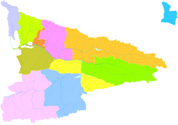
Ili Kazakh Autonomous Prefecture is administratively divided into three parts -- Altay Prefecture and Tacheng Prefecture, together with a direct-administered region that includes Yining City, 2 other county-level cities, 7 counties and 1 autonomous county. In the legal status itself is only a prefecture-level division, which is a special case in China's administrative divisions. It is not accurate to regard Ili Kazakh Autonomous Region as a sub-provincial division, which has no legal basis. This situation can only assume that, the autonomous prefecture enjoys partial authority in sub-provincial division. Its direct-administered region is exactly coterminous with the historical area that in the past was often called by Russians and Westerners as Kulja or Kuldja.[11]
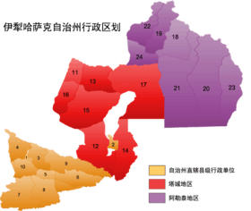 Ili Prefecture under its direct administration |
|||||||||||
| Part | Division code |
Name | Chinese | Hanyu Pinyin | Uyghur (UEY) | Uyghur Latin (ULY) | Kazakh (Arabic script) |
Kazakh Latin alphabet | Population (2010 Census) |
Area (km2) | Density (/km2) |
|---|---|---|---|---|---|---|---|---|---|---|---|
| Ili Prefecture (direct administration) |
654002 | Yining[12] | 伊宁市 | Yīníng Shì | غۇلجا شەھىرى | Ghulja Shehiri | قۇلجا قالاسى | Qulja qalasy | 515,082 | 629 | 818.89 |
| 654003 | Kuytun[12] | 奎屯市 | Kuítún Shì | كۈيتۇن شەھىرى | Küytun Shehiri | كۇيتۇن قالاسى | Kýıtyn qalasy | 166,261 | 1,171 | 141.98 | |
| 654004 | Korgas[12] | 霍尔果斯市 | Huò'ěrguǒsī Shì | قورغاس شەھىرى | Qorghas Shehiri | قالاسى قورعاس | Qorǵas qalasy | 85,000(?) | 1,900 | 44.73 | |
| 654021 | Yining County[12] | 伊宁县 | Yīníng Xiàn | غۇلجا ناھىيىسى | Ghulja Nahiyisi | قۇلجا اۋدانى | Qulja aýdany | 372,590 | 4,486 | 83.05 | |
| 654020 | Qapqal Xibe Autonomous County | 察布查尔锡伯自治县 | Chábùchá'ěr Xībó Zìzhìxiàn | چاپچال شىبە ئاپتونوم ناھىيىسى | Chapchal Shibe Aptonom Nahiyisi | شاپشال سىبە اۆتونوميالى اۋدانى | Shapshal Sybe avtonomıalyq aýdany | 179,744 | 4,489 | 40.04 | |
| 654023 | Huocheng County[12] | 霍城县 | Huòchéng Xiàn | قورغاس ناھىيىسى | Qorghas Nahiyisi | قورعاس اۋدانى | Qorǵas aýdany | 352,689 | 5,466 | 64.52 | |
| 654024 | Gongliu County[12] | 巩留县 | Gǒngliú Xiàn | توققۇزتارا ناھىيىسى | Toqquztara Nahiyisi | توعىزتاراۋ اۋدانى | Toǵyztaraý aýdany | 164,860 | 4,124 | 39.97 | |
| 654025 | Xinyuan County[12] | 新源县 | Xīnyuán Xiàn | كۈنەس ناھىيىسى | Künes Nahiyisi | كۇنەس اۋدانى | Kúnes aýdany | 282,718 | 7,583 | 37.28 | |
| 654026 | Zhaosu County[12] | 昭苏县 | Zhāosū Xiàn | موڭغۇلكۈرە ناھىيىسى | Mongghulküre Nahiyisi | موڭعۇلكۇرە اۋدانى | Mońǵulkúre aýdany | 148,187 | 10,465 | 14.16 | |
| 654027 | Tekes County | 特克斯县 | Tèkèsī Xiàn | تېكەس ناھىيىسى | Tëkes Nahiyisi | تەكەس اۋدانى | Tekes aýdany | 142,713 | 8,080 | 17.66 | |
| 654028 | Nilka County | 尼勒克县 | Nílèkè Xiàn | نىلقا ناھىيىسى | Nilqa Nahiyisi | نىلقى اۋدانى | Nylqy aýdany | 157,743 | 10,130 | 15.57 | |
| ↪ Altay Prefecture | 阿勒泰地区 | Ālètài Dìqū | ئالتاي ۋىلايىتى | Altay Wilayiti | التاي ايماعى | Altaı aımaǵy | 603,283 | 117,800 | 5.12 | ||
| ↪ Tacheng Prefecture[12] | 塔城地区 | Tǎchéng Dìqū | تارباغاتاي ۋىلايىتى | Tarbaghatay Wilayiti | تارباعاتاي ايماعى | Tarbaǵataı aımaǵy | 1,219,369 | 104,546 | 11.66 | ||

Ethnic groups
Ili is a multi-ethnic autonomous prefecture, there are 13 local ethnic groups: Kazakh, Han, Uyghur, Hui, Mongol, Xibe, Kyrgyz, Uzbek, Manchu, Tatar, Russ, Daur and Tajik peoples.[13] As of the end of 2018, it had a population of 4,582,500; of which 2,745,500 were ethnic minorities, which accounted for 59.9% of its total population.[2]
A 2015 report provided the following ethnic breakdown of the population: the Han people numbered at 1,934,571 (making up 41.19% of the population), the Kazakh population was 1,257,003 (26.77%), Uyghurs were 819,701 (17.45%), Hui at 433,045 (9.22%), Mongols were 75,597 (1.61%), Xibes were 34,457, 22,428 Kyrgyz, 8,298 Uzbeks, 8,298 Daurs, 5,394 Russians, 5,199 Manchus, 2,852 Tatars, 153 Tajiks and 91,749 'others'.[14]
Tourism
Ili Kazakh Autonomous Prefecture is a famous tourist destination for its relatively humid climate, which earned its reputation as 'wetland in Central Asia'. Major tourist attractions include Narati Grassland, Guozigou and Kanas Lake. In 2015 alone, Ili has seen over 25 million travellers and earned over 19 billion CNY (US$2.92 billion) tourism receipts.[15]
Transport
Road and Railway
An extensive road network is being built across the prefecture for economic development. In 2015, 66 million passengers travelled on road.
The railway has extended to both the very north part of Altay City and the westmost city of Khorgas on the China-Kazakhstan border.
Border crossings
Ili Kazak's 8 functioning ports of entry are:
- With Kazakhstan
- Aqimbek (Chinese: 阿黑木别克) of Altay Prefecture
- Bakhtu (巴克图), 17 km (11 mi) from Tacheng; another primary point or port
- Dulat (都拉塔), in Qapqal Xibe Autonomous County: under Ili
- Jeminay (吉木乃) of Altay Prefecture; another primary point or port
- Khorgas (霍尔果斯), in Huocheng County; under Ili; a primary Chinese "national" border crossing point or port of entry
- Muzart (木扎尔特), in Zhaosu County: directly controlled by Ili; another primary point or port
- With Mongolia
- Khiziltaw (红山嘴) of Altay Prefecture
- Taskhin (塔克什肯) of Altay Prefecture to Khovd
- Dayan-Khunshanzyui of Altay Prefecture to Bayan-Ölgii. Only open during Summer.[16]
Head
First Secretary
- Zhao Tianjie (赵天杰)
Governors
- Pätiqan Sügirbayev (Chinese: zh:帕提汗·苏古尔巴也夫; Kazakh: Фатхан (Пәтіхан) Дәлелханұлы Сүгірбаев), November 1954 – June 1955
- Jağda Babalıqulı (贾和达·巴巴里科夫; Жағда Бабалықұлы), June 1955 – February 1957 Acting Act, from May 1958
- Qurmanäli Ospanulı (库尔班阿里·乌斯曼诺夫; Құрманәлі Оспанұлы), June 1958 – September 1963
- Erğalï Äbilqaýırulı (zh:伊尔哈里·阿不力海依尔; Ерғали Әбілқайырұлы), September 1963 – May 1969
- Zhong Liangshu (钟良树,[17] Чұң Лияң Шо), May 1969 – May 1970 (military government)
- Wang Zhenzhong (王振中,[17] Уаң Жын Жұң), May 1970 – July 1975 (military government)
- Xie Gaozhong (谢高忠,[17] Шие Гау Жұң), July 1975 – September 1975 (military government)
- Jänäbil Smağululı (贾那布尔•司马胡里; Жанәбіл Смағұлұлы), September 1975 – February 1978
- Qasımbek Seýitjanulı (哈生别克·赛依提江; Қасымбек Сейітжанұлы), March 1979 – April 1983
- Dïyar Qurmaşulı (迪牙尔·库马什; Дияр Құрмашұлы), April 1983 – May 1988
- Ashat Kerimbay (艾斯海提·克里木拜; Асхат Керімбайұлы), May 1988 – May 1993
- Bekmuxamet Musaulı (别克木哈买提·木沙, Бекмұхамет Мұсаұлы), April 1993 – March 1998
- Alpısbaý Raxımulı (阿勒布斯拜·拉合木, Алпысбай Рахымұлы), March 1998 – June 2001
- Nurlan Äbilmäjinulı (努尔兰·阿不都满金, Нұрлан Әбілмәжінұлы), March 2002 – January 2003
- Qızaýjan Seýilqojaulı (柯赛江·赛力禾加, Қызайжан Сейілқожаұлы), March 2003 – November 2007
- Mäwken Seýitqamzaulı (毛肯·赛衣提哈木扎; Мәукен Сейітқамзаұлы), November 2007 – January 2012
- Mänen Zeýnelulı (马宁·再尼勒, Мәнен Зейнелұлы), February 2012 – January 2016
- Qurmaş Sırjanulı (库尔玛什·斯尔江, Құрмаш Сыржанұлы), from February 2016[18][19][20]
Notable persons
References
Citations
- 伊犁哈萨克自治州概况. xzqh.org. 2014-12-02. Retrieved 2019-08-11.
- 伊犁州2018年国民经济和社会发展统计公报. tjcn.org. 2019-05-21. Retrieved 2019-08-13.
- As per Kim (2004), pp. 54, 229
- Info from Chinese Wikipedia and "History". Yining County Historical Development. Archived from the original on 2007-01-06.
- Direct distance from modern maps
- Road distance from Lansdell (1885), p. 190
- 阿拉腾奥其尔著 (1996). 清代伊犁将军论稿. Publishing House of Minority Nationalities. also see 清代伊犁将军论稿. book118.com. 2018-08-23. Retrieved 2019-08-22.
- 新疆伊犁哈萨克自治州来源、地位及与塔城、阿勒泰地区关系. fangdd.com. 2016-06-03. Retrieved 2019-08-22.
- 伊犁哈萨克自治州历史沿革. xzqh.org. 2014-12-02. Retrieved 2019-08-22.
- 伊犁哈萨克自治州地理概况与生态环境. Yili Normal University. Retrieved 2019-08-13.
- Encyclopædia Britannica. 1911.
- The official spelling according to 中国地名录. Beijing: SinoMaps Press (中国地图出版社). 1997. ISBN 7-5031-1718-4.
- Office of the Ili Prefecture Historical Almanac (新疆伊犁地区史志办公室) (2000). 伊犁历代移民开发与世居民族的形成. 新疆大学学报(社会科学版). Retrieved 2019-08-13.
- 2016年新疆统计年鉴. xingjiang.stats.gov.cn. 2016-08-17. Retrieved 2019-08-14.
- "National Data". Archived from the original on 6 February 2017. Retrieved 18 April 2016.
- http://discover-bayanolgii.com/travelers-information/
- 伊犁哈萨克自治州地方志编纂委员会 (June 2004). 伊犁哈萨克自治州志 (in Chinese). Ürümqi: Xinjiang People's Publishing House. p. 282. ISBN 7-228-08827-1. Retrieved 3 May 2019.
- (ҚЫТАЙДАҒЫ ІЛЕ ҚАЗАҚ АВТОНОМИЯЛЫ ОБЛЫСЫН БАСҚАРҒАНДАР.)
- (Ауыт Мұқибек. О, менің Іле Қазақ облысым!. Абай ақпарат порталы.)
- (Дауылбек, ed. (2017-02-05). Қытайдағы қазақ облсы басшыларының қысқаша өмір баяны, іле қазақ Автономиялы облысы құрылғаннан бергі облыс бастықтарының қысқаша өмір баяны (in Kazakh). Жүңгө қазақ радио торабы.)
Sources
- Henry Lansdell, "Russian Central Asia: Including Kuldja, Bokhara, Khiva and Merv". Full text available at Google Books; there is also a 2001 facsimile reprint of the 1885 edition, ISBN 1-4021-7762-3. (Chapters XIV-XVI describe Lansdell visit to the area in the early 1880s, soon after the Russian withdrawal). (in English)
External links
| Wikimedia Commons has media related to Ili Kazakh Autonomous Prefecture. |
- Official site (in Chinese)
- Official site (in Kazakh)
- Subdivision info (in Simplified Chinese)
- A TALE OF TWO CITIES: NEW MUSEUMS FOR YINING AND URUMQI "CHINA HERITAGE NEWSLETTER", China Heritage Project, The Australian National University. ISSN 1833-8461. No. 3, September 2005. (Talks about Ili Kazak Autonomous Prefecture Museum in Yining).