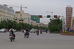
Kargilik County
Kargilik County[4][5] (transliterated from Uyghur: قاغىلىق ناھىيىسى ; Chinese: 喀格勒克县); from Mandarin Chinese Yecheng County (Chinese: 叶城县), is a county in southwest of the Xinjiang Uyghur Autonomous Region and is under the administration of the Kashgar Prefecture. It contains an area of 28,600 km². To the north, the county borders Makit County. To the east, the county borders Guma County (Pishan) in Hotan Prefecture. To the west, the county borders Yarkant County, Poskam County and Taxkorgan Tajik Autonomous County. In the south, the county has a border of more than 80 km (50 mi) with Pakistan and India administered areas of Kashmir.[2]
Kargilik County قاغىلىق ناھىيىسى 叶城县 Yecheng; Karghalik; Yehcheng | |
|---|---|
County | |
 | |
.png) Location of Kargilik County (red) within Kashgar Prefecture (yellow) and Xinjiang | |
 Kargilik Location of the seat in Xinjiang | |
| Coordinates: 37°53′06″N 77°24′47″E | |
| Country | People's Republic of China |
| Autonomous region | Xinjiang |
| Prefecture | Kashgar Prefecture |
| Seat | Kargilik Town |
| Population (2010)[1] | |
| • Total | 454,328 |
| Ethnic groups | |
| • Major ethnic groups | Uyghur, Han Chinese[2][3] |
| Time zone | UTC+8 (China Standard) |
| Postal code | 844900 |
| Website | www |
| Kargilik County | |||||||||||
|---|---|---|---|---|---|---|---|---|---|---|---|
| Uyghur name | |||||||||||
| Uyghur | قاغىلىق ناھىيىسى | ||||||||||
| |||||||||||
| Chinese name | |||||||||||
| Traditional Chinese | 葉城縣 | ||||||||||
| Simplified Chinese | 叶城县 | ||||||||||
| |||||||||||
| Alternative Chinese name | |||||||||||
| Traditional Chinese | 喀格勒克縣 | ||||||||||
| Simplified Chinese | 喀格勒克县 | ||||||||||
| |||||||||||
History
In 1975, future Communist Party of China Deputy Party Secretary of the Xinjiang Uyghur Autonomous Region Zhu Hailun was sent to Kargilik County in the Down to the Countryside Movement.[6]
On August 20, 2013, a raid by police on a group of Uyghurs suspected of terrorism and illegal religious activities in Yilkiqi (Yilikeqi) lead to fifteen or more deaths.[7][8]
According to Radio Free Asia, in June 2016, five persons in the county who were encouraging others to fast for Ramadan were taken away by plainclothes police.[9]
Satellite images revealed that between September 2018 and April 2019, a mosque in Kargilik County was demolished.[10]
Geography
The northern part of the county is in the Taklamakan Desert and the southern part of the county is in the Kunlun Mountains. Mazar Pass is located in the southern part of the county.
Administrative divisions
- Kargilik Town (Kageleke, Qaghiliq; قاغىلىق بازىرى / 喀格勒克镇), Charbagh Town (Qia'erbage; چارباغ بازىرى / 恰尔巴格镇), Ushsharbash Town (Wuxiabashi; ئۇششارباش بازىرى / 乌夏巴什镇; also Wuxiakebashi 乌夏克巴什镇)
Township (يېزىسى / 乡)
- Loq Township (Luoke; لوق يېزىسى / 洛克乡), Besheriq Township (Baxireke; بەشئېرىق يېزىسى / 伯西热克乡), Tetir Township (Tieti; تېتىر يېزىسى / 铁提乡), Chasa Meschit Township (Qiasameiqite, Qiasimiqiti; چاسا مەسچىت يېزىسى / 恰萨美其特乡 / 恰斯米其提乡 [12]), Tögichi Township (Tuguqi; تۆگىچى يېزىسى / 吐古其乡), Janggilieski Township (Jianggelesi; جاڭگىلىئەسكى يېزىسى / 江格勒斯乡), Jayterak Township[13] (Jiayitileke, Janyterek; جايتېرەك يېزىسى / 加依提勒克乡), Barin Township (Baren; بارىن يېزىسى / 巴仁乡), Ghojaeriq Township (Wujireke; غوجائېرىق يېزىسى / 乌吉热克乡), Shaxap Township (Xiahefu; شاخاپ يېزىسى / 夏合甫乡), Yilkiqi Township (Yilikeqi, Yilqichi; يىلقىچى يېزىسى / 依力克其乡), Yitimliqum Township (Yitimukong; يىتىملىقۇم يېزىسى / 依提木孔乡), Zunglang Township (Zonglang; زۇڭلاڭ يېزىسى / 宗朗乡), Kokyar Township (Kekeya; كۆكيار يېزىسى / 柯克亚乡), Shixshu Township (Xihexiu; شىخشۇ يېزىسى / 西合休乡), Chipan Township (Qipan; چىپان يېزىسى / 棋盘乡), Saybagh Township (Sayibage; سايباغ يېزىسى / 萨依巴格乡)
Others (其他)
- 兵团叶城牧场 | 阿克塔什农场 | 普萨牧场 | 叶城县公安农场 | 叶城县良种场 | 叶城县园艺场 | 叶城县林场 | 叶城县种畜场
Economy
Kargilik County's economy is based on agriculture and animal husbandry. Agricultural products include wheat, corn and cotton, as well as pomegranates, yellow pears, walnuts, and dried apricots. Industries include construction, machinery, electronics, and food processing. The county is known for the 'Kargilik Banximao Sheep' (叶城半细毛羊).[14]
Demographics
| Historical population | ||
|---|---|---|
| Year | Pop. | ±% p.a. |
| 2000 | 370,229 | — |
| 2010 | 454,328 | +2.07% |
| [1] | ||
In 1997, Uyghurs made up 93% of the population of the county and Han Chinese made up 6% of the population.[3]
According to the 2002 census, it has a population of 370,000.
As of 2015, 490,417 of the 519,962 residents of the county were Uyghur, 23,408 were Han Chinese and 6,137 were from other ethnic groups.[15]
As of 2018, Uyghurs made up 91% of the population of the county.[16]
As of 1999, 90.78% of the population of Kargilik (Yecheng) County was Uyghur and 8.18% of the population was Han Chinese.[17]
Historical maps
Historical English-language maps including Kargilik:
_p61_PLATE19._SINKIANG_(14597194848).jpg) Map including Kargilik (labeled as Kargalik) (1917)
Map including Kargilik (labeled as Kargalik) (1917)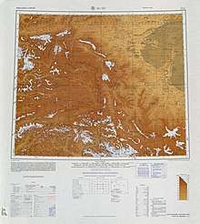 Map including Kargilik (labeled as YEH-CH'ENG (KARGHALIK)) and surrounding region from the International Map of the World (AMS, 1966)
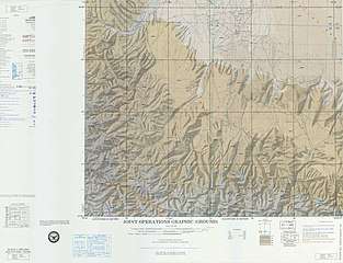 Map including Kargilik (labeled as Yeh-ch'eng (Karghalik)) (ACIC, 1969)
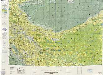 From the Operational Navigation Chart; map including Kargilik (labeled as YECHENG (YEH-CH'ENG)) (DMA, 1980)[lower-alpha 1]
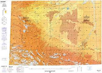 Map including Kargilik (labeled as YECHENG (YEH-CH'ENG)) (DMA, 1984)[lower-alpha 2]
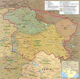 The southern part of Kargilik County includes territory ceded to China by Pakistan but claimed by India
See also
Notelist
- From map: "The representation of international boundaries is not necessarily authoritative."
- From map: "The representation of international boundaries is not necessarily authoritative"
References
- 叶城县历史沿革. XZQH.org (in Chinese). 14 November 2010. Retrieved 31 January 2020.
2000年第五次人口普查,叶城县常住总人口370229人,{...}2010年第六次人口普查,叶城县常住总人口454328人,其中:喀格勒克镇75730人,恰尔巴格镇21189人,乌夏巴什镇21582人,洛克乡20612人,伯西热克乡33486人,铁提乡15656人,恰萨美其特乡17515人,吐古其乡20476人,江格勒斯乡18844人,加依提勒克乡23374人,巴仁乡10139人,乌吉热克乡20763人,夏合甫乡18734人,依力克其乡14869人,依提木孔乡36052人,宗朗乡6247人,柯克亚乡19451人,西合休乡5535人,棋盘乡16224人,萨依巴格乡22525人,公安农场425人,阿克塔什农场545人,良种场1861人,园艺场1378人,林场1148人,普萨牧场1076人,种畜场348人,恰其库木管理区7562人,兵团叶城牧场982人。
- 叶城概况. 叶城县人民政府网 (in Chinese). Archived from the original on 21 January 2019. Retrieved 31 January 2020 – via Internet Archive.
全县国土总面积3.1万平方公里,耕地面积113万亩。县辖20个乡镇、5个农林牧场、1个管理区,总人口50余万人,聚居着维吾尔、汉、哈萨克、回、柯尔克孜、蒙古、塔吉克、俄罗斯、乌孜别克等13个主要民族,其中维吾尔族占93%、汉族占6%、其它少数民族占1%。与巴基斯坦、印控克什米尔地区接壤,边境线长达80多公里。
- 1997年叶城县行政区划. XZQH.org (in Chinese). 19 November 2010. Retrieved 31 January 2020.
有维吾尔、汉、柯尔克孜、乌孜别克、塔吉克、回等民族,其中维吾尔族占93%,汉族占6%,
- "Foreign Ministry Spokesperson Hua Chunying's Regular Press Conference on June 23, 2014". Ministry of Foreign Affairs of the People's Republic of China. 23 June 2014. Retrieved 31 January 2020.
The Xinhua news agency has released information on the terrorist violent attack happened on June 21 in Kargilik county of Xinjiang, to which you may refer.
- Li Fangfang (23 February 2017). "Opportunity in Diversity". Beijing Review. Retrieved 24 March 2020.
Four years ago, Nurahmet Memet was a farmer in northwest China's Xinjiang Uygur Autonomous Region. Today, he no longer leads a hardscrabble life in southern Kargilik County, next to the Taklamakan Desert, and instead has become a successful company manager and businessman after relocating to central Xinjiang.
- Chavkin, Sasha (2019-11-24). "China Cables. Xinjiang's Architect of Mass Detention Zhu Hailun". International Consortium of Investigative Journalists (ICIJ). Retrieved 2019-11-24.
- Shohret Hoshur, Parameswaran Ponnudurai (25 August 2013). "At Least 15 Uyghurs Killed in Police Shootout in Xinjiang". Radio Free Asia. Translated by Mamatjan Juma. Retrieved 14 April 2020.CS1 maint: uses authors parameter (link)
- Andrew Jacobs (7 October 2013). "Uighurs in China Say Bias Is Growing". New York Times. Retrieved 14 April 2020.
a few days later at least a dozen other Uighurs were killed as they prayed at a farmhouse in Yilkiqi township, according to Radio Free Asia. The authorities said the men were taking part in “illegal religious activities” and training for a terrorist attack, but did not provide further details.
- Luisetta Mudie (6 June 2016). "China Enters Ramadan With Round-The-Clock Surveillance of Mosques, Uyghurs". Radio Free Asia. Translated by Luisetta Mudie. Retrieved 15 April 2020.
Authorities in northwestern China's troubled Xinjiang region have detained 17 people for encouraging the region's mostly Muslim Uyghurs to fast during the holy month of Ramadan, overseas rights groups said on Monday.
Five Uyghurs were taken away by plainclothes police in Qaghiliq county (in Chinese, Yecheng county) near the Silk Road city of Kasghar on Friday, the World Uyghur Congress (WUC) said as Ramadan began. - Alexandra Ma (28 April 2019). "Before-and-after photos show how China is destroying historical sites to monitor and intimidate its Muslim minority". Business Insider. Retrieved 14 April 2020.
- 2018年统计用区划代码和城乡划分代码:叶城县 (in Chinese). National Bureau of Statistics of the People's Republic of China. 2018. Retrieved 27 January 2020.
统计用区划代码 名称 653126100000 喀格勒克镇 653126101000 恰尔巴格镇 653126102000 乌夏巴什镇 653126200000 洛克乡 653126201000 伯西热克乡 653126202000 铁提乡 653126203000 恰萨美其特乡 653126204000 吐古其乡 653126205000 江格勒斯乡 653126206000 加依提勒克乡 653126207000 巴仁乡 653126208000 乌吉热克乡 653126209000 夏合甫乡 653126210000 依力克其乡 653126211000 依提木孔乡 653126212000 宗朗乡 653126213000 柯克亚乡 653126214000 西合休乡 653126215000 棋盘乡 653126216000 萨依巴格乡 653126402000 阿克塔什农场 653126403000 良种场 653126404000 园艺场 653126405000 林场 653126408000 恰其库木管理区 653126409000 叶城工业园区 653126500000 兵团叶城牧场
- 恰斯米其提乡简介. 叶城县人民政府网 (in Chinese). 19 August 2015. Retrieved 14 April 2020.
- Jayterak (Approved - N) at GEOnet Names Server, United States National Geospatial-Intelligence Agency
- 夏征农; 陈至立, eds. (September 2009). 辞海:第六版彩图本 [Cihai (Sixth Edition in Color)] (in Chinese). 上海. Shanghai: 上海辞书出版社. Shanghai Lexicographical Publishing House. p. 2678. ISBN 9787532628599.
经济以农、牧业为主,农产小麦、玉米和棉花,并产石榴、香梨、核桃、杏干。工业有建材、机械、电力、食品加工等。畜产以“叶城半细毛羊”著名。
- 3-7 各地、州、市、县(市)分民族人口数 (in Chinese). Xinjiang Uyghur Autonomous Region Bureau of Statistics. Archived from the original on 2017-10-11. Retrieved 2017-09-03.
- 叶城概况 [Kargilik Overview]. 叶城县人民政府网 (in Chinese). 15 August 2018. Archived from the original on 20 December 2018. Retrieved 23 March 2020.
总人口55万余人,其中维吾尔族占91%。
- Morris Rossabi, ed. (2004). Governing China’s Multiethnic Frontiers (PDF). University of Washington Press. p. 179. ISBN 0-295-98390-6.