Baiyin
Baiyin (simplified Chinese: 白银; traditional Chinese: 白銀; pinyin: Báiyín; lit.: 'Silver') is a prefecture-level city in northeastern Gansu province, People's Republic of China.
Baiyin 白银市 | |
|---|---|
 Baiyin city view | |
| Nickname(s): 铜城 (Copper City) | |
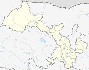
.png) Location of Baiyin Prefecture within Gansu | |
 Baiyin Location of the city center in Gansu | |
| Coordinates (Baiyin municipal government): 36°32′42″N 104°08′20″E | |
| Country | People's Republic of China |
| Region | Gansu |
| Municipal seat | Baiyin District |
| Area | |
| • Total | 21,200 km2 (8,200 sq mi) |
| Elevation | 1,698 m (5,571 ft) |
| Population (2010)[1] | |
| • Total | 1,708,751 |
| • Density | 81/km2 (210/sq mi) |
| Time zone | UTC+8 (China Standard) |
| Postal code | 730900 |
| Area code(s) | 0943 |
| ISO 3166 code | CN-GS-04 |
| Vehicle registration | 甘D |
| Website | www |
Geography and climate
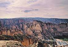
Baiyin is part loess plateau, part desert. Elevation ranges from 1,275 to 3,321 meters (4,183 to 10,896 feet) above sea-level. The climate is very arid with only 110–352 mm (4.3–13.9 in) of annual precipitation. Annual evaporation is 2,101 mm (82.7 in) resulting in a net loss of approximately 1,800 mm (71 in). The Yellow River flows from south to north for 214 km (133 mi) through Baiyin.
The area is 21,200 km2 (8,200 sq mi), 3,478 km2 (1,343 sq mi) of that urban.
| Climate data for Baiyin (1981–2010 normals) | |||||||||||||
|---|---|---|---|---|---|---|---|---|---|---|---|---|---|
| Month | Jan | Feb | Mar | Apr | May | Jun | Jul | Aug | Sep | Oct | Nov | Dec | Year |
| Average high °C (°F) | 0.6 (33.1) |
4.8 (40.6) |
10.6 (51.1) |
17.7 (63.9) |
22.8 (73.0) |
26.4 (79.5) |
28.5 (83.3) |
27.1 (80.8) |
21.9 (71.4) |
15.5 (59.9) |
8.5 (47.3) |
2.1 (35.8) |
15.5 (60.0) |
| Daily mean °C (°F) | −6.2 (20.8) |
−2.5 (27.5) |
3.9 (39.0) |
10.8 (51.4) |
16.1 (61.0) |
20.1 (68.2) |
22.0 (71.6) |
20.5 (68.9) |
15.6 (60.1) |
9.0 (48.2) |
1.5 (34.7) |
−4.8 (23.4) |
8.8 (47.9) |
| Average low °C (°F) | −11.2 (11.8) |
−7.3 (18.9) |
−1.6 (29.1) |
4.5 (40.1) |
9.6 (49.3) |
13.8 (56.8) |
16.0 (60.8) |
14.8 (58.6) |
10.4 (50.7) |
3.8 (38.8) |
−3.7 (25.3) |
−9.7 (14.5) |
3.3 (37.9) |
| Average precipitation mm (inches) | 1.5 (0.06) |
0.9 (0.04) |
3.4 (0.13) |
8.4 (0.33) |
21.3 (0.84) |
31.5 (1.24) |
39.9 (1.57) |
42.6 (1.68) |
27.1 (1.07) |
13.4 (0.53) |
1.3 (0.05) |
0.4 (0.02) |
191.7 (7.56) |
| Average relative humidity (%) | 50 | 45 | 43 | 40 | 42 | 47 | 54 | 58 | 61 | 59 | 52 | 51 | 50 |
| Source: China Meteorological Administration[2] | |||||||||||||
Administration
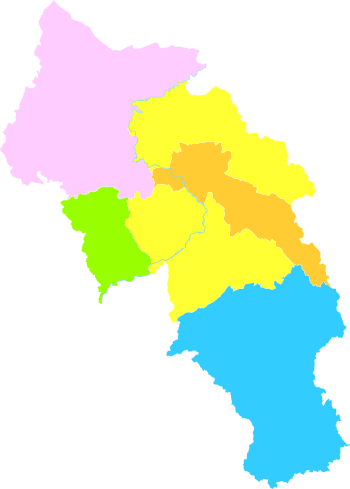
Baiyin has 2 urban districts, 3 counties, 64 townships, 18 towns, and 7 sub-districts with a total population of 1,746,800(2011).
| Map | ||||||
|---|---|---|---|---|---|---|
| Name | Simplified Chinese |
Hanyu Pinyin | Population (2010) |
Area (km²) |
Density (/km²) | |
| Baiyin District | 白银区 | Báiyín Qū | 294,400 | 1,372 | 215 | |
| Pingchuan District | 平川区 | Píngchuān Qū | 192,398 | 2,106 | 91 | |
| Jingyuan County | 靖远县 | Jìngyuǎn Xiàn | 454,925 | 5,809 | 78 | |
| Huining County | 会宁县 | Huìníng Xiàn | 541,273 | 6,439 | 84 | |
| Jingtai County | 景泰县 | Jǐngtài Xiàn | 225,755 | 5,483 | 41 | |
Economy
The Baiyin Nonferrous operates copper, zinc and selenium mines around Baiyin, although these mines are getting exhausted of ore. Financed by development funds, a high-tech park is being built, which is home to a contact lens factory.[3][4] Pingchuan District and Huining County are the largest coal production bases in Gansu province.
Transportation
Baiyin is directly served by the Baotou–Lanzhou railway, China National Highway 109 and G6 Beijing–Lhasa Expressway.
References
- Main data bulletin of the sixth national census in 2010 Archived 2014-11-29 at the Wayback Machine, 2011-05-09(in Chinese)
- 中国气象数据网 - WeatherBk Data (in Chinese). China Meteorological Administration. Retrieved 2020-04-16.
- "Not so grim up north-west". 9 January 2014.
- 全省唯一隐形眼镜自主研发生产企业:甘肃康视达科技集团在银揭牌 (in Chinese). Baiyin People's Government. 4 August 2012. Archived from the original on 30 June 2016. Retrieved 31 May 2016.
External links
Major cities along the Yellow River | ||
|---|---|---|
| Province-level subdivisions | Cities (from upper reaches to lower reaches) |  |
| Gansu | ||
| Ningxia |
| |
| Inner Mongolia | ||
| Shanxi | ||
| Shaanxi | ||
| Henan | ||
| Shandong | ||
Major cities along the Pearl River · Major cities along the Yangtze River | ||
| Authority control |
|---|