Gaoyou
Gaoyou (simplified Chinese: 高邮; traditional Chinese: 高郵; pinyin: Gāoyóu; lit.: 'high post (stop)'), is a county-level city under the administration of Yangzhou, Jiangsu province, China, located in the Yangtze River Delta on the north side of the Yangtze River.
Gaoyou 高邮市 Kaoyu | |
|---|---|
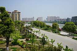 A view of Gaoyou urban area north of Haichao Bridge | |
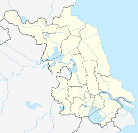 Gaoyou Location in Jiangsu | |
| Coordinates: 32°50′42″N 119°30′29″E[1] | |
| Country | People's Republic of China |
| Province | Jiangsu |
| Prefecture-level city | Yangzhou |
| Area | |
| • County-level city | 1,963 km2 (758 sq mi) |
| • Water | 788 km2 (304 sq mi) |
| • Urban (2018)[2] | 39 km2 (15 sq mi) |
| Population (2008) | |
| • County-level city | 824,000 |
| • Density | 420/km2 (1,100/sq mi) |
| • Urban (2018)[2] | 240,000 |
| • Urban density | 6,200/km2 (16,000/sq mi) |
| Time zone | UTC+8 (China Standard) |
| Postal code | 225600 |
| Area code(s) | 0514 |
History
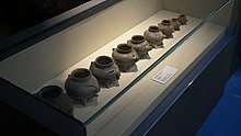
Recent archaeological finds at the Longqiuzhuang site in Gaoyou has found evidence of rice growing dating back 5,500-7,000 years. Gaoyou ting (commune, 亭) located in this area was established in Qin dynasty. Then Gaoyou county whose seat was the former commune was established in BC 118.[3]
In 1353, Zhang Shicheng revolted and captured the walled city of Gaoyou. In the next year, Zhang established Kingdom of Dazhou, while Gaoyou functioned as its temporary capital until 1356. Later, the city withstood the siege led by Toqto'a, since the complicated politics severely reduced the cohesion of the Yuan army. At that time, it was one of the 46 important mail posts along the Grand Canal between Beijing and Nanjing. It was in use until the 1911 Revolution. On 2 October 1939, the Japanese army captured the walled city. On 19 January 1949, the CPC controlled the walled city.
The profound history and culture of Gaoyou fostered Qin Shaoyou, the well-known poet in the Song Dynasty, Wang Nianshun and Wang Yinzhi (father and son), the celebrated classics interpreters in the Qing Dynasty, Sun Yunzhu, the modern paleontologist and Wang Zengqi, the contemporary writer. Gaoyou is also the hometown of the infamous Wu Sangui.
A total of about 200,000 people drowned to death in their sleep in Gaoyou alone due the devastating flooding of 1931.[4][5] Gaoyou was the most badly affected place during the floods.[6]
More than 30,000 people starved to death in Gaoyou county during the great famine, of which more than 10,000 were children.[7]
Administration

The sole ethnic township of Jiangsu, Lingtang Hui Ethnic township, is under the jurisdiction of Gaoyou, about a third of the township residents are Hui Chinese.
Subdistrict
- Gaoyou (高邮)
- Mapeng (马棚)
Town
- Cheluo (车逻)
- Ganduo (甘垛)
- Jieshou (界首)
- Linze (临泽)
- Longqiu (龙虬)
- Sanduo (三垛)
- Songqiao (送桥)
- Tangzhuang (汤庄)
- Xiejia (卸甲)
- Zhoushan (周山)
Township
- Lingtang Hui Ethnic (菱塘回族乡)
Geography

Gaoyou is located in the central part of Jiangsu Province, which is also part of Yangtze River Delta. It borders Baoying and Jinhu to the north, Jiangdu to the south and Xinghua to east.[8] There are over twenty townships, Lingtang Hui Ethnic Township is the only Minority Township in the province. The population in this county is approximately eighty-three thousand. The total area is 1963 square kilometres with 1175 square kilometres of land area and 788 square kilometres of water surface area.[8] Gaoyou is a plain region which full of rivers and lakes. Gaoyou Lake is the third largest lake in Jiangsu, which closes to The Grand Canal from Beijing to Hangzhou. Geographical location provides important water resources and rich aquatic products for this county.[8]
Gaoyou is located at 32.79 degrees north latitude and 119.44 degrees east longitude.[9] It belongs to the subtropical monsoon climate. The hottest in July is around 27.6 °C (81.7 °F) while the coldest in January is about 1.7 °C (35.1 °F). The average annual temperature is 15.0 °C (59.0 °F). The wet-season is from mid June to July and the average annual rainfall is about 1,000 mm (39 in). The average annual relative humidity is 67%, at the meantime, the frost-free season is more than 200 days. Gaoyou has the characteristics of mild climate, adequate rainfall, four distinctive seasons, sufficient sunshine and long frost free period.[8]
Economy

Gaoyou was dependent on its agriculture and aquaculture sections financially. Primary agricultural products include rapeseed, rice, wheat, poultry and eggs. A variety of aquatic products contain fish, crab and shrimp. The environment in this county has been well protected by the government.The local government has closed many factories in order to protect the lakes.[8]
Transport
Roads
Expressways
- G2 Beijing–Shanghai Expressway. It passes just to the east of the city.[8]
National Highway
- China National Highway 233
References
- Google (2014-07-02). "Gaoyou" (Map). Google Maps. Google. Retrieved 2014-07-02.
- Cox, Wendell (2018). Demographia World Urban Areas. 14th Annual Edition (PDF). St. Louis: Demographia. p. 22.
- 讀史方輿紀要, Vol. 23: "高郵廢縣今州治。秦高郵亭也。漢置縣,屬廣陵國,後皆為高郵縣。宋始為高郵軍治。元為府治。明初省。今州城周十里有奇。"
- Liam D'Arcy-Brown (2010). Emperor's River: Travels to the Heart of a Resurgent China. Eye Books. ISBN 978-1-90864-687-3.
- National Flood Relief Commission Report of the National Flood Relief Commission Shanghai, 1932
- Ho-fung Hung (2013). Protest with Chinese Characteristics: Demonstrations, Riots, and Petitions. Columbia University Press. p. 74. ISBN 978-0-23115-203-7.
- "Gaoyou". Jiangsu.NET. Retrieved 14 April 2018.
- "Where Is Gaoyou, China?". worldatlas. Retrieved 14 April 2018.
External links
| Wikivoyage has a travel guide for Gaoyou. |
- Gaoyou Information Website
- Gaoyou City English guide
- (in English and Chinese) "Illustrated Album of Yangzhou Prefecture", from 1573–1620, has illustrations of Gaoyou
Jiangsu topics | |
|---|---|
Nanjing (capital) | |
| General | |
| Geography |
|
| Education | |
| Culture |
|
| Visitor attractions |
|
| |
| Authority control |
|
|---|