Bortala Mongol Autonomous Prefecture
Bortala (Chinese: 博尔塔拉蒙古族自治州; pinyin: Bóěrtǎlā Měnggǔzú Zìzhìzhōu) is an autonomous prefecture for Mongol people in the northern middle of Xinjiang Uyghur Autonomous Region, Western China. It has an area of 27,000 km2 (10,000 sq mi). Bole is its capital. "Boro tala" comes from the Mongolian language and means "brown steppe".
Bortala Prefecture 博尔塔拉州 · بۆرتالا ئوبلاستى | |
|---|---|
| Bortala Mongol Autonomous Prefecture 博尔塔拉蒙古自治州 بۆرتالا موڭغۇل ئاپتونوم ئوبلاستى | |
 Alataw Pass in Bortala Prefecture | |
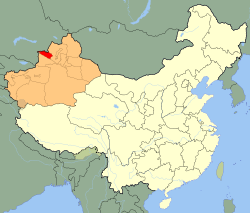 Bortala Mongol Prefecture (red) in Xinjiang (orange) | |
| Coordinates (Bortala Prefecture government): 44°54′22″N 82°03′59″E | |
| Country | People's Republic of China |
| Autonomous region | Xinjiang |
| Prefectural seat | Bole |
| Time zone | UTC+8 (China Standard) |
| ISO 3166 code | CN-XJ-27 |
| Bortala Mongol Autonomous Prefecture | |||||||||||
|---|---|---|---|---|---|---|---|---|---|---|---|
| Chinese name | |||||||||||
| Simplified Chinese | 博尔塔拉蒙古自治州 | ||||||||||
| Traditional Chinese | 博爾塔拉蒙古自治州 | ||||||||||
| |||||||||||
| Mongolian name | |||||||||||
| Mongolian Cyrillic | Боротал-а-ыин Монгол өбэртэгэн жасақу жеү | ||||||||||
| Mongolian script | ᠪᠣᠷᠣᠲᠠᠯᠠ ᠮᠣᠩᠭᠣᠯ ᠥᠪᠡᠷᠲᠡᠭᠡᠨ ᠵᠠᠰᠠᠬᠤ ᠵᠧᠦ | ||||||||||
| |||||||||||
| Uyghur name | |||||||||||
| Uyghur | بۆرتالا موڭغۇل ئاپتونوم ئوبلاستى | ||||||||||
| |||||||||||
| Oirat name | |||||||||||
| Oirat | ᡋᡆᠷᡆᡐᠠᠯᠠ ᡏᡆᡊᡎᡆᠯ ᡄᡋᡄᠷᡄᡃᠨ ᠴᠠᠰᠠᡍᡇ ᡓᡇᡇ Borotala mongγol ebereen zasaqu ǰuu | ||||||||||
Geography
Bortala is located in the southwestern part of the Dzungarian Basin. It occupies a V-shaped basin between the Dzungarian Alatau in the northwest and the Borohoro Mountains in the southwest.
The prefecture borders Kazakhstan to the north and west, and has an international border of 385 km (239 mi). To the east it borders Wusu City and Toli County of Tacheng Prefecture; to the south it borders Nilka County, Yining County, and Huocheng County of Ili Kazakh Autonomous Prefecture.
The prefecture has two large lakes, Ebi-Nur and Sayram Lake.
Administrative divisions
Bortala is divided into two county-level cities, Bole and Alashankou; and two counties: Jinghe County and Wenquan County. In addition, it is home to the Fifth Agricultural Division of the Xinjiang Production and Construction Corps and its 11 regiment-level farms / ranches.
| Map | ||||||||
|---|---|---|---|---|---|---|---|---|
| Name | Hanzi | Hanyu Pinyin | Uyghur (UEY) | Uyghur Latin (ULY) | Mongolian | Population (2010 Census) | Area (km²) | Density (/km²) |
| Bole[1] | 博乐市 | Bólè Shì | بۆرتالا شەھىرى | Börtala Shehiri | ᠪᠣᠷᠢᠲᠠᠯᠠ ᠬᠣᠲᠠ | 235,585 | 7,802 | 30.19 |
| Alashankou | 阿拉山口市 | Ālāshānkǒu Shì | ﺋﺎﻻﺗﺎﯞ ﺋﯧﻐﯩﺰﻯ | Alataw Shehiri | ᠠᠯᠠᠭ ᠠᠭᠤᠯᠠ ᠬᠣᠲᠠ | 10,000(?) | 43 | 232.55 |
| Jinghe County[1] | 精河县 | Jīnghé Xiàn | جىڭ ناھىيىسى | Jing Nahiyisi | ᠵᠢᠩ ᠾᠧ ᠰᠢᠶᠠᠨ | 141,593 | 11,189 | 12.65 |
| Wenquan County[1] | 温泉县 | Wēnquán Xiàn | ئارىشاڭ ناھىيىسى | Arishang Nahiyisi | ᠷᠠᠰᠢᠶᠠᠨ ᠰᠢᠶᠠᠨ | 66,502 | 5,862 | 11.34 |

History
The Tang dynasty created the Shuanghe Protectorate in this area. During the Yuan and Ming dynasties the area was the territory of the Oirats. Chahar Mongols were moved here during the Qing dynasty from Kalgan, while Torghuud Oirats moved eastwards from the Volga.
The People's Republic of China established the autonomous prefecture on July 13, 1954.
Demographics
There are 35 nationalities in Bortala. According to the 2010 census, 65% of the 443,680 inhabitants are Han Chinese, while the remainder are Mongol, Uyghur, Kazakh, Hui, or of other nationalities.[2]
- Population by ethnicity (2010)[2]
| Ethnicity | Population | % |
|---|---|---|
| Han | 288,220 | 64.96% |
| Uyghur | 59,106 | 13.32% |
| Kazakhs | 44,417 | 10.01% |
| Mongol | 25,125 | 5.66% |
| Hui | 23,180 | 5.22% |
| Dongxiang | 1,455 | 0.33% |
| Zhuang | 345 | 0.08% |
| Xibe | 273 | 0.06% |
| Tibetan | 271 | 0.06% |
| Tujia | 267 | 0.06% |
| Manchu | 193 | 0.04% |
| Russian | 114 | 0.03% |
| Uzbek | 90 | 0.02% |
| Kyrgyz | 74 | 0.02% |
| Others | 550 | 0.12% |
| Total | 443,680 | 100% |
Economy
In 2004 the prefecture had a total gross domestic product of 3.69 billion Renminbi (including the XPCC 5th division), an increase of 11.9% over the previous year. Annual total imports and exports totalled US$ 554 million, an increase of 96.8% over the previous year. Average annual salary was 11000 Renminbi, an increase of 7.6%; average annual pure income per capita for agricultural workers was 3904 Renminbi, an increase of 10.8%.
Transport
Alashankou is a port of entry with both railroads and roads linking China with Kazakhstan; it is also one of China's national first-class port of entry (国家一类口岸). The volume of imports / exports passing through Alashankou accounts for 90% of the total for all of Xinjiang, and has been second to only Manzhouli, Inner Mongolia among land ports-of-entry in China for 8 days.
See also
- Ethnic Mongols in China
References
- The official spelling according to 中国地名录. Beijing: SinoMaps Press (中国地图出版社). 1997. ISBN 7-5031-1718-4.
- Stanley W. Toops (August 2012). Susan M. Walcott; Corey Johnson (eds.). Eurasian Corridors of Interconnection: From the South China to the Caspian Sea. Routledge. pp. 65–66. ISBN 978-1135078751.
External links
- Bortala Government website(in Chinese)
- Bortala Government website(in Mongolian)
| Regions |
|  | |||||||
|---|---|---|---|---|---|---|---|---|---|
| Prefectures and counties |
| ||||||||
| |||||||||