Langzhong
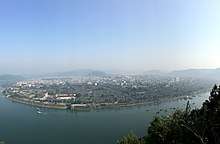
Langzhong is a county-level city in northeastern Sichuan province, China, located on the middle reaches of the Jialing River. It is administered as part of the prefecture-level city of Nanchong. Langzhong has a total population of 840,000, with 200,000 residing in the urban area.
Langzhong 阆中市 | |
|---|---|
.png) Location of Langzhong City (red) in Nanchong City (yellow) and Sichuan | |
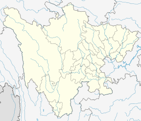 Langzhong Location of the city centre in Sichuan | |
| Coordinates (Langzhong government): 31°33′29″N 106°00′18″E | |
| Country | People's Republic of China |
| Province | Sichuan |
| Provincial city | Langzhong |
| Administrative divisions of the People's Republic of China | 52 |
| Area | |
| • Total | 1,877 km2 (725 sq mi) |
| Population | |
| • Total | 840,000 |
| • Density | 450/km2 (1,200/sq mi) |
| Time zone | UTC+8 (China Standard Time) |
| Langzhong | |||||||
|---|---|---|---|---|---|---|---|
| Traditional Chinese | 閬中 | ||||||
| Simplified Chinese | 阆中 | ||||||
| Literal meaning | Within the Dry Moat | ||||||
| |||||||
| Former names | |||||||
|---|---|---|---|---|---|---|---|
| Baoning | |||||||
| Traditional Chinese | 保寧 | ||||||
| Simplified Chinese | 保宁 | ||||||
| Literal meaning | Pacified-Protecting | ||||||
| |||||||
History
The site of present-day Langzhong served for a time as the capital of Ba, a native but sinicized Sichuan state during China's Warring States period. It takes its present name from its role as the seat of Langzhong County, established by Qin two years after[1] its 316 BC conquest of Shu and Ba. Under the Han and Tang, it was an important center for astronomical research. Under the Yuan, Ming, and Qing, it was known as Baoning.[lower-alpha 1] Over the late imperial period, it served as Sichuan's provincial capital for a total of ten years. It was well known for its salt wells.[2]
Since 1985, the PRC government has awarded Langzhong with various accolades on three separate occasions.[1] In 1986 the State Council named it a famous and historical town. In 1991, it was finally upgraded to county-level city status.
Geography
Langzhong is located in the northeast of the province and the northern part of the Sichuan Basin on the middle reaches of the Jialing River. Within the city's administrative area, elevations generally increase from southwest to northeast and range from 328 metres (1,076 ft) to 888 metres (2,913 ft), while rivers flow for 59.4 kilometres (36.9 mi).[1] The area is dominated by low-lying mountains and hills.
Climate
As with much of the rest of the province, Langzhong has a monsoon-influenced humid subtropical climate (Köppen Cwa), with dry, temperate winters, and long, hot, humid summers. The monthly daily average temperature ranges from 6.1 °C (43.0 °F) in January to 26.7 °C (80.1 °F) in July. The frost-free period lasts 290 days per year, while annual sunshine amounts to 1,400 hours.[1] Close to two-thirds of the annual rainfall occurs from June to September.
| Climate data for Langzhong (1981−2010) | |||||||||||||
|---|---|---|---|---|---|---|---|---|---|---|---|---|---|
| Month | Jan | Feb | Mar | Apr | May | Jun | Jul | Aug | Sep | Oct | Nov | Dec | Year |
| Record high °C (°F) | 20.8 (69.4) |
23.6 (74.5) |
31.1 (88.0) |
34.9 (94.8) |
36.4 (97.5) |
36.3 (97.3) |
39.6 (103.3) |
40.6 (105.1) |
37.9 (100.2) |
31.3 (88.3) |
26.9 (80.4) |
18.6 (65.5) |
40.6 (105.1) |
| Average high °C (°F) | 9.7 (49.5) |
12.2 (54.0) |
16.8 (62.2) |
22.4 (72.3) |
26.9 (80.4) |
29.1 (84.4) |
31.3 (88.3) |
31.3 (88.3) |
26.5 (79.7) |
21.2 (70.2) |
16.4 (61.5) |
10.7 (51.3) |
21.2 (70.2) |
| Daily mean °C (°F) | 6.1 (43.0) |
8.4 (47.1) |
12.3 (54.1) |
17.3 (63.1) |
21.8 (71.2) |
24.6 (76.3) |
26.7 (80.1) |
26.3 (79.3) |
22.2 (72.0) |
17.2 (63.0) |
12.4 (54.3) |
7.4 (45.3) |
16.9 (62.4) |
| Average low °C (°F) | 3.6 (38.5) |
5.6 (42.1) |
8.9 (48.0) |
13.4 (56.1) |
17.7 (63.9) |
20.9 (69.6) |
23.2 (73.8) |
22.8 (73.0) |
19.3 (66.7) |
14.6 (58.3) |
9.7 (49.5) |
5.1 (41.2) |
13.7 (56.7) |
| Record low °C (°F) | −2.5 (27.5) |
−1.7 (28.9) |
−0.9 (30.4) |
4.0 (39.2) |
10.0 (50.0) |
14.3 (57.7) |
17.4 (63.3) |
17.0 (62.6) |
13.3 (55.9) |
2.6 (36.7) |
0.7 (33.3) |
−3.4 (25.9) |
−3.4 (25.9) |
| Average precipitation mm (inches) | 13.4 (0.53) |
16.2 (0.64) |
28.5 (1.12) |
63.1 (2.48) |
114.4 (4.50) |
148.8 (5.86) |
208.1 (8.19) |
195.1 (7.68) |
134.7 (5.30) |
61.0 (2.40) |
30.7 (1.21) |
12.8 (0.50) |
1,026.8 (40.41) |
| Average relative humidity (%) | 79 | 76 | 73 | 72 | 71 | 77 | 80 | 78 | 82 | 82 | 81 | 81 | 78 |
| Source 1: China Meteorological Data Service Center[3] | |||||||||||||
| Source 2: Weather China (precipitation days 1971-2000) | |||||||||||||
Transport
References
- Encyclopædia Britannica, 9th ed. (1878), Vol. V, "China".
- 中国地面气候标准值月值(1981-2010) (in Chinese). China Meteorological Data Service Center. Retrieved 20 October 2018.