Pingliang
Pingliang (simplified Chinese: 平凉; traditional Chinese: 平涼; pinyin: Píngliàng; lit.: 'flat cool') is a prefecture-level city in eastern Gansu province, China, bordering Shaanxi province to the south and east and the Ningxia Hui Autonomous Region to the north. Pingliang is well known for the nearby Kongtong Mountains, which are sacred to Taoism and location of the mythical meeting place of the Yellow Emperor and Guangchengzi, an immortal.
Pingliang 平凉市 | |
|---|---|
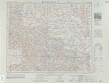
.png) Location of Pingliang City jurisdiction in Gansu | |
| Coordinates (Pingliang municipal government): 35°32′33″N 106°39′54″E | |
| Country | People's Republic of China |
| Province | Gansu |
| Municipal seat | Kongtong District |
| Area | |
| • Prefecture-level city | 11,196.71 km2 (4,323.07 sq mi) |
| Elevation | 1,398 m (4,587 ft) |
| Population (2010)[1] | |
| • Prefecture-level city | 2,068,033 |
| • Density | 180/km2 (480/sq mi) |
| • Metro | 110,483 |
| Time zone | UTC+8 (China Standard) |
| Postal code | 744000 |
| Area code(s) | 0933 |
| ISO 3166 code | CN-GS-08 |
| Licence plate prefixes | 甘L |
| Website | www |
List of divisions
| Map | ||||||
|---|---|---|---|---|---|---|
| Name | Chinese | Hanyu Pinyin | Population (2010) |
Area (km²) | Density (/km²) | |
| Kongtong District | 崆峒区 | Kōngtóng Qū | 504,848 | 1,936 | 261 | |
| Huating City | 华亭市 | Huátíng Shì | 189,333 | 1,183 | 160 | |
| Jingchuan County | 泾川县 | Jīngchuān Xiàn | 281,145 | 1,409 | 200 | |
| Lingtai County | 灵台县 | Língtái Xiàn | 183,937 | 2,038 | 88 | |
| Chongxin County | 崇信县 | Chóngxìn Xiàn | 102,116 | 852 | 120 | |
| Zhuanglang County | 庄浪县 | Zhuānglàng Xiàn | 382,827 | 1,558 | 246 | |
| Jingning County | 静宁县 | Jìngníng Xiàn | 423,827 | 2,193 | 193 | |

Geography
Pingliang ranges in latitude from 34° 54' to 35° 46' N and in longitude from 105° 20' to 107° 51' E. Bordering prefecture-level cities are Xianyang (Shaanxi) to the east, Baoji (Shaanxi) and Tianshui to the south, Dingxi and Baiyin to the west, and Guyuan (Ningxia) and Qingyang to the north. It is located on the Loess Plateau with elevations ranging from 890 to 2,957 metres (2,920 to 9,701 ft); the city proper itself is at an altitude of around 1,400 m (4,590 ft).
Due to its altitude of around 1,400 m (4,590 ft), Pingliang has a monsoon-influenced, four-season, humid continental climate (Köppen Dwb), with cold but dry winters, and warm and humid summers. The monthly 24-hour average temperature ranges from −4.2 °C (24.4 °F) in January to 21.5 °C (70.7 °F) in July. Much of the annual rainfall occurs from June to September, and the annual mean temperature is 9.28 °C (48.7 °F). With monthly percent possible sunshine ranging from 46% in September to 65% in December, the city receives 2,381 hours of bright sunshine annually.
| Climate data for Pingliang (Kongtong District, 1981–2010 normals) | |||||||||||||
|---|---|---|---|---|---|---|---|---|---|---|---|---|---|
| Month | Jan | Feb | Mar | Apr | May | Jun | Jul | Aug | Sep | Oct | Nov | Dec | Year |
| Record high °C (°F) | 17.3 (63.1) |
23.4 (74.1) |
28.4 (83.1) |
32.6 (90.7) |
33.4 (92.1) |
35.9 (96.6) |
36.0 (96.8) |
35.0 (95.0) |
33.8 (92.8) |
27.8 (82.0) |
22.8 (73.0) |
17.9 (64.2) |
36.0 (96.8) |
| Average high °C (°F) | 2.4 (36.3) |
5.3 (41.5) |
11.0 (51.8) |
18.0 (64.4) |
22.6 (72.7) |
26.2 (79.2) |
27.5 (81.5) |
25.7 (78.3) |
20.9 (69.6) |
15.1 (59.2) |
9.5 (49.1) |
3.8 (38.8) |
15.7 (60.2) |
| Daily mean °C (°F) | −4.2 (24.4) |
−0.9 (30.4) |
4.4 (39.9) |
10.9 (51.6) |
15.8 (60.4) |
19.6 (67.3) |
21.5 (70.7) |
20.0 (68.0) |
15.2 (59.4) |
9.0 (48.2) |
2.7 (36.9) |
−2.7 (27.1) |
9.3 (48.7) |
| Average low °C (°F) | −8.9 (16.0) |
−5.5 (22.1) |
−0.6 (30.9) |
4.9 (40.8) |
9.5 (49.1) |
13.4 (56.1) |
16.2 (61.2) |
15.3 (59.5) |
10.8 (51.4) |
4.6 (40.3) |
−2.0 (28.4) |
−7.2 (19.0) |
4.2 (39.6) |
| Record low °C (°F) | −22.5 (−8.5) |
−19.1 (−2.4) |
−15.2 (4.6) |
−8.8 (16.2) |
−1.5 (29.3) |
4.3 (39.7) |
8.7 (47.7) |
5.5 (41.9) |
−0.7 (30.7) |
−7.9 (17.8) |
−16.6 (2.1) |
−24.3 (−11.7) |
−24.3 (−11.7) |
| Average precipitation mm (inches) | 3.8 (0.15) |
6.0 (0.24) |
13.9 (0.55) |
26.3 (1.04) |
45.8 (1.80) |
64.9 (2.56) |
104.6 (4.12) |
98.5 (3.88) |
69.6 (2.74) |
37.2 (1.46) |
7.8 (0.31) |
2.2 (0.09) |
480.6 (18.94) |
| Average precipitation days (≥ 0.1 mm) | 3.6 | 5.0 | 6.7 | 7.9 | 9.6 | 10.7 | 12.4 | 12.9 | 11.5 | 9.2 | 4.6 | 2.4 | 96.5 |
| Average relative humidity (%) | 55 | 56 | 56 | 54 | 58 | 63 | 71 | 76 | 78 | 74 | 64 | 57 | 64 |
| Mean monthly sunshine hours | 192.8 | 164.8 | 177.5 | 211.7 | 237.8 | 233.0 | 229.8 | 216.6 | 168.7 | 173.1 | 180.0 | 195.2 | 2,381 |
| Percent possible sunshine | 62 | 54 | 48 | 54 | 55 | 54 | 52 | 52 | 46 | 50 | 58 | 65 | 54 |
| Source: China Meteorological Administration (precipitation days and sunshine 1971–2000)[2][3] | |||||||||||||
Landslide disaster
In July 2010 13 people died in Huating County in a landslide triggered by heavy rains. Two people survived.[4]
Transport
- G22 Qingdao–Lanzhou Expressway, which motorists can take to reach the south of neighbouring Ningxia and eventually Lanzhou, the provincial capital
- China National Highway 312, which motorists can take to reach Xi'an
Notable residents
- Zhao Jiping, film composer (b. 1945)
References
- Main data bulletin of the sixth national census in 2010 Archived 2014-11-29 at the Wayback Machine, 2011-05-09(in Chinese)
- 中国气象数据网 - WeatherBk Data (in Chinese). China Meteorological Administration. Retrieved 2020-04-15.
- 中国地面国际交换站气候标准值月值数据集(1971-2000年). China Meteorological Administration. Archived from the original on 2013-09-21. Retrieved 2010-05-25.
- "13 die in northwest China landslide". People's Daily. Xinhua. July 24, 2010. Retrieved 2016-10-13.
External links
Gansu topics | |
|---|---|
Lanzhou (capital) | |
| General | |
| Geography | |
| Education |
|
| Culture | |
| Cuisine |
|
| Visitor attractions |
|
| |